Nottingham, New Hampshire
| Nottingham, New Hampshire | ||
|---|---|---|
| Town | ||
| ||
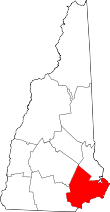
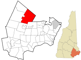 Location in Rockingham County and the state of New Hampshire. | ||
| Coordinates: 43°06′52″N 71°05′59″W / 43.11444°N 71.09972°WCoordinates: 43°06′52″N 71°05′59″W / 43.11444°N 71.09972°W | ||
| Country | United States | |
| State | New Hampshire | |
| County | Rockingham | |
| Incorporated | 1722 | |
| Government | ||
| • Board of Selectmen |
Donna Danis Tiler Eaton Charlene Andersen | |
| • Town Administrator | Chris Sterndale | |
| Area | ||
| • Total | 48.4 sq mi (125.4 km2) | |
| • Land | 46.5 sq mi (120.4 km2) | |
| • Water | 1.9 sq mi (5.0 km2) 4.01% | |
| Elevation | 259 ft (79 m) | |
| Population (2010) | ||
| • Total | 4,785 | |
| • Density | 99/sq mi (38/km2) | |
| Time zone | Eastern (UTC-5) | |
| • Summer (DST) | Eastern (UTC-4) | |
| ZIP code | 03290 | |
| Area code(s) | 603 | |
| FIPS code | 33-57460 | |
| GNIS feature ID | 0873690 | |
| Website |
www | |

Nottingham is a town in Rockingham County, New Hampshire, United States. The population was 4,785 at the 2010 census.[1] It is the location of Pawtuckaway State Park.
History
Incorporated in 1722 by Lieutenant Governor John Wentworth, Nottingham was named for Daniel Finch, 2nd Earl of Nottingham. The earl was a close friend of Samuel Shute and Joseph Dudley, previous colonial governors of New Hampshire. Among the grantees was Peregrine White, descendant of Peregrine White of the Mayflower, the first child of English parentage born in New England. At one time, the town had 17 watermills in operation.
The town was site of a massacre in 1747, when Elizabeth Simpson, Robert Beard and Nathaniel Folsom were slain by Indians of the Winnipesaukee tribe.
Nottingham once included Deerfield, incorporated in 1766, and Northwood, in 1773.
Geography
According to the United States Census Bureau, the town has a total area of 48.4 square miles (125 km2), of which 46.5 sq mi (120 km2) is land and 1.9 sq mi (4.9 km2) is water, comprising 4.01% of the town. Containing 14 lakes and ponds, Nottingham is drained by the Pawtuckaway and North rivers, in addition to Back Creek. The town's highest point is the North Peak of Mount Pawtuckaway, at 995 feet (303 m) above sea level. The circular-shaped Pawtuckaway Mountains are a prime example of what geologists term a ring dike complex.
Demographics
| Historical population | |||
|---|---|---|---|
| Census | Pop. | %± | |
| 1790 | 1,068 | — | |
| 1800 | 964 | −9.7% | |
| 1810 | 1,063 | 10.3% | |
| 1820 | 1,126 | 5.9% | |
| 1830 | 1,157 | 2.8% | |
| 1840 | 1,193 | 3.1% | |
| 1850 | 1,268 | 6.3% | |
| 1860 | 1,297 | 2.3% | |
| 1870 | 1,130 | −12.9% | |
| 1880 | 1,095 | −3.1% | |
| 1890 | 988 | −9.8% | |
| 1900 | 638 | −35.4% | |
| 1910 | 607 | −4.9% | |
| 1920 | 520 | −14.3% | |
| 1930 | 451 | −13.3% | |
| 1940 | 468 | 3.8% | |
| 1950 | 566 | 20.9% | |
| 1960 | 623 | 10.1% | |
| 1970 | 952 | 52.8% | |
| 1980 | 1,952 | 105.0% | |
| 1990 | 2,939 | 50.6% | |
| 2000 | 3,701 | 25.9% | |
| 2010 | 4,785 | 29.3% | |
| Est. 2015 | 4,942 | [2] | 3.3% |
As of the census[4] of 2000, there were 3,701 people, 1,331 households, and 1,048 families residing in the town. The population density was 79.6 people per square mile (30.8/km²). There were 1,592 housing units at an average density of 34.3 per square mile (13.2/km²). The racial makeup of the town was 98.38% White, 0.19% African American, 0.19% Native American, 0.57% Asian, 0.03% Pacific Islander, 0.27% from other races, and 0.38% from two or more races. Hispanic or Latino of any race were 0.70% of the population.
There were 1,331 households out of which 40.3% had children under the age of 18 living with them, 68.9% were married couples living together, 6.1% had a female householder with no husband present, and 21.2% were non-families. 15.0% of all households were made up of individuals and 3.5% had someone living alone who was 65 years of age or older. The average household size was 2.78 and the average family size was 3.09.
In the town the population was spread out with 27.8% under the age of 18, 4.3% from 18 to 24, 33.7% from 25 to 44, 27.0% from 45 to 64, and 7.2% who were 65 years of age or older. The median age was 38 years. For every 100 females there were 102.9 males. For every 100 females age 18 and over, there were 101.7 males.
The median income for a household in the town was $62,423, and the median income for a family was $65,510. Males had a median income of $41,182 versus $29,738 for females. The per capita income for the town was $24,879. About 0.9% of families and 2.5% of the population were below the poverty line, including 1.2% of those under age 18 and 2.3% of those age 65 or over.
Education
The town of Nottingham provides kindergarten through 8th grade education at Nottingham Elementary School. The town pays tuition to Dover High School for its high school-aged students,[5] and also has an agreement with Coe-Brown Northwood Academy in neighboring Northwood.
Notable people
- Bradbury Cilley, U.S. congressman
- Joseph Cilley, state senator and Revolutionary War era general
- Henry Dearborn, U.S. congressman from Massachusetts and Revolutionary War era general
- Else Holmelund Minarik, author of children's books
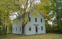
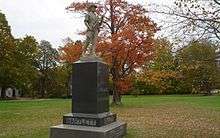
Sites of interest
References
- ↑ United States Census Bureau, American FactFinder, 2010 Census figures. Retrieved March 23, 2011.
- ↑ "Annual Estimates of the Resident Population for Incorporated Places: April 1, 2010 to July 1, 2015". Retrieved July 2, 2016.
- ↑ "Census of Population and Housing". Census.gov. Retrieved June 4, 2016.
- ↑ "American FactFinder". United States Census Bureau. Retrieved 2008-01-31.
- ↑ Nottingham Community Profile, NH Dept. of Employment Security website
External links
- Town of Nottingham official website
- New Hampshire Economic and Labor Market Information Bureau Profile