Hampton, New Hampshire
| Hampton, New Hampshire | ||
|---|---|---|
|
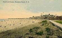
Great Boar's Head c. 1920 | ||
| ||
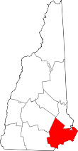
 Location in Rockingham County and the state of New Hampshire. | ||
| Coordinates: 42°56′15″N 70°50′20″W / 42.93750°N 70.83889°WCoordinates: 42°56′15″N 70°50′20″W / 42.93750°N 70.83889°W | ||
| Country | United States | |
| State | New Hampshire | |
| County | Rockingham | |
| Incorporated | 1639 | |
| Government | ||
| • Board of Selectmen |
Rusty Bridle, Chair James Waddell Rick Griffin Philip Bean Regina Barnes | |
| • Town Manager | Frederick W. Welch | |
| Area | ||
| • Total | 14.7 sq mi (38.1 km2) | |
| • Land | 12.9 sq mi (33.4 km2) | |
| • Water | 1.8 sq mi (4.7 km2) 12.38% | |
| Elevation | 36 ft (11 m) | |
| Population (2010) | ||
| • Total | 14,976 | |
| • Density | 1,000/sq mi (390/km2) | |
| Time zone | Eastern (UTC-5) | |
| • Summer (DST) | Eastern (UTC-4) | |
| ZIP codes | 03842–03843 | |
| Area code(s) | 603 | |
| FIPS code | 33-33060 | |
| GNIS feature ID | 0873616 | |
| Website |
www | |


Hampton is a town in Rockingham County, New Hampshire, United States. The population was 14,976 at the 2010 census.[1][2] Located beside the Atlantic Ocean, Hampton is home to Hampton Beach, a summer tourist destination.
The densely populated central settlement of the town, where 9,656 people resided at the 2010 census,[1] is defined as the Hampton census-designated place (CDP) and is centered on the intersection of U.S. 1 and NH 27.
History
First called the Plantation of Winnacunnet, Hampton was one of four original New Hampshire townships chartered by the General Court of Massachusetts, which then held authority over the colony. "Winnacunnet" is an Algonquian Abenaki word meaning "pleasant pines" and is the name of the town's high school, serving students from Hampton and surrounding towns.
In March 1635, Richard Dummer and John Spencer of the Byfield section in Newbury, came round in their shallop, came ashore at the landing and were much impressed by the location. Dummer, who was a member of the General Court, got that body to lay its claim to the section and plan a plantation here. The Massachusetts General Court of March 3, 1636 ordered that Dummer and Spencer be given power to "To presse men to build there a Bound house".[3]
The town was settled in 1638 by a group of parishioners led by Reverend Stephen Bachiler, who had formerly preached at the settlement's namesake: Hampton, England. Incorporated in 1639, the township once included Seabrook, Kensington, Danville, Kingston, East Kingston, Sandown, North Hampton and Hampton Falls.
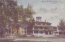
Among Hampton's earliest settlers was Thomas Leavitt, who previously had been among the first settlers at Exeter. His descendant Thomas Leavitt Esq., lived in Hampton Falls, and was the leading Democratic politician in southern New Hampshire for many years.[4] He made a noted early survey and plan of the town of Hampton in 1806.[5] James Leavitt, of the same family, occupied the home which had previously belonged to Gen. Jonathan Moulton.[5] Later members of the family ran Leavitts' Hampton Beach Hotel, a fixture in the area for generations.[5]
Construction of the railroad in the 1850s, as well as the Exeter and Hampton Trolley line, made Hampton's oceanfront a popular resort. Hampton Beach remains a tourist destination, offering shops, restaurants, beaches, and summer seasonal housing.
Geography
According to the United States Census Bureau, the town has a total area of 14.7 square miles (38.1 km2), of which 12.9 square miles (33.4 km2) is land and 1.8 square miles (4.7 km2) is water, comprising 12.38% of the town.[6] The town center, or CDP, has a total area of 5.4 sq mi (14 km2), of which 5.4 sq mi (14 km2) is land and 0.1 sq mi (0.26 km2) (1.11%) is water.
Hampton is drained by the Hampton and Drakes rivers. The town lies fully within the New Hampshire Coastal watershed.[7] The highest point in Hampton is Bride Hill (approximately 150 feet (46 m) above sea level), near the town line with Exeter.
Climate
| Climate data for Hampton, New Hampshire | |||||||||||||
|---|---|---|---|---|---|---|---|---|---|---|---|---|---|
| Month | Jan | Feb | Mar | Apr | May | Jun | Jul | Aug | Sep | Oct | Nov | Dec | Year |
| Record high °F (°C) | 62 (17) |
72 (22) |
89 (32) |
94 (34) |
94 (34) |
96 (36) |
101 (38) |
104 (40) |
96 (36) |
86 (30) |
78 (26) |
75 (24) |
104 (40) |
| Average high °F (°C) | 34 (1) |
38 (3) |
45 (7) |
57 (14) |
68 (20) |
77 (25) |
82 (28) |
81 (27) |
73 (23) |
61 (16) |
50 (10) |
39 (4) |
58.8 (14.8) |
| Average low °F (°C) | 15 (−9) |
18 (−8) |
25 (−4) |
34 (1) |
43 (6) |
53 (12) |
59 (15) |
57 (14) |
50 (10) |
39 (4) |
31 (−1) |
21 (−6) |
37.1 (2.8) |
| Record low °F (°C) | −26 (−32) |
−15 (−26) |
−6 (−21) |
13 (−11) |
15 (−9) |
33 (1) |
38 (3) |
33 (1) |
23 (−5) |
17 (−8) |
−6 (−21) |
−17 (−27) |
−26 (−32) |
| Average precipitation inches (mm) | 3.61 (91.7) |
3.70 (94) |
4.99 (126.7) |
4.70 (119.4) |
4.24 (107.7) |
4.34 (110.2) |
4.10 (104.1) |
3.49 (88.6) |
4.05 (102.9) |
4.57 (116.1) |
4.86 (123.4) |
4.39 (111.5) |
51.04 (1,296.4) |
| Source: The Weather Channel (Historical Monthly Averages) [8] | |||||||||||||
Demographics
| Historical population | |||
|---|---|---|---|
| Census | Pop. | %± | |
| 1790 | 853 | — | |
| 1800 | 875 | 2.6% | |
| 1810 | 990 | 13.1% | |
| 1820 | 1,098 | 10.9% | |
| 1830 | 1,102 | 0.4% | |
| 1840 | 1,320 | 19.8% | |
| 1850 | 1,192 | −9.7% | |
| 1860 | 1,230 | 3.2% | |
| 1870 | 1,177 | −4.3% | |
| 1880 | 1,184 | 0.6% | |
| 1890 | 1,330 | 12.3% | |
| 1900 | 1,209 | −9.1% | |
| 1910 | 1,215 | 0.5% | |
| 1920 | 1,251 | 3.0% | |
| 1930 | 1,507 | 20.5% | |
| 1940 | 2,137 | 41.8% | |
| 1950 | 2,847 | 33.2% | |
| 1960 | 5,379 | 88.9% | |
| 1970 | 8,011 | 48.9% | |
| 1980 | 10,493 | 31.0% | |
| 1990 | 12,324 | 17.4% | |
| 2000 | 14,973 | 21.5% | |
| 2010 | 14,976 | 0.0% | |
| Est. 2015 | 15,281 | [9] | 2.0% |
As of the census of 2000, there were 14,937 people, 6,465 households, and 4,034 families residing in the town. The population density was 1,146.0 people per square mile (442.6/km²). There were 9,349 housing units at an average density of 277.0 persons/km² (717.3 persons/sq mi). The racial makeup of the town was 97.57% White, 0.39% African American, 0.17% Native American, 0.86% Asian, 0.07% Pacific Islander, 0.25% from other races, and 0.68% from two or more races. 0.90% of the population were Hispanic or Latino of any race.
There were 6,465 households out of which 26.1% had children under the age of 18 living with them, 50.6% were married couples living together, 8.7% have a woman whose husband does not live with her, and 37.6% were non-families. 30.0% of all households were made up of individuals and 9.7% had someone living alone who was 65 years of age or older. The average household size was 2.28 and the average family size was 2.86.
In the town the population was spread out with 21.4% under the age of 18, 5.4% from 18 to 24, 30.5% from 25 to 44, 28.0% from 45 to 64, and 14.7% who were 65 years of age or older. The median age was 41 years. For every 100 females there were 94.5 males. For every 100 females age 18 and over, there were 92.6 males.
The median income for a household in the town was $54,419, and the median income for a family was $66,000. Males had a median income of $46,727 versus $31,695 for females. The per capita income for the town was $29,878. 5.9% of the population and 4.5% of families were below the poverty line. Out of the total people living in poverty, 7.5% are under the age of 18 and 7.1% are 65 or older.
Town center
As of the census of 2000, there were 9,126 people, 3,800 households, and 2,473 families living in the central settlement, or census-designated place (CDP). The population density was 1,701.4 people per square mile (657.4/km²). There were 4,020 housing units at an average density of 289.6 persons/km² (749.5 persons/sq mi). The racial makeup of the settlement was 97.81% White, 0.19% African American, 0.08% Native American, 1.08% Asian, 0.05% Pacific Islander, 0.25% from other races, and 0.54% from two or more races. 0.89% of the population were Hispanic or Latino of any race.

There were 3,800 households out of which 29.2% had children under the age of 18 living with them, 54.3% were married couples living together, 8.2% have a woman whose husband does not live with her, and 34.9% were non-families. 28.3% of all households were made up of individuals and 11.2% had someone living alone who was 65 years of age or older. The average household size was 2.36 and the average family size was 2.93.
In the CDP the population was spread out with 23.1% under the age of 18, 4.6% from 18 to 24, 30.5% from 25 to 44, 26.4% from 45 to 64, and 15.3% who were 65 years of age or older. The median age was 41 years. For every 100 females there were 91.7 males. For every 100 females age 18 and over, there were 88.3 males.
The median income for a household is $57,356, and the median income for a family was $71,094. Males had a median income of $50,130 versus $32,468 for females. The per capita income for the town was $30,769. 3.9% of the population and 1.9% of families were below the poverty line. Out of the total people living in poverty, 1.6% are under the age of 18 and 8.7% are 65 or older.
Sites of interest
Notable people
- Bill Alfonso, professional wrestling personality
- Stephen Bachiler, English clergyman; town founder
- Eunice "Goody" Cole, only woman convicted of witchcraft in New Hampshire
- Henry Dearborn, physician, general and 5th US Secretary of War
- Abraham Drake, Continental Army during the Revolutionary War and politician
- Thomas Leavitt, early settler
- Stephen E. Merrill, 77th governor of New Hampshire
- Jonathan Moulton, Revolutionary War era brigadier general
- Jane Pierce, First Lady of the United States, wife of Franklin Pierce
- Trish Regan, business news broadcaster
- Tristram Shaw, US congressman
References
- 1 2 United States Census Bureau, American FactFinder, 2010 Census figures. Retrieved April 1, 2011.
- ↑ "NOTE: Change to the New Hampshire 2010 P.L. 94-171 Summary File data as delivered" (PDF). U.S. Census Bureau. Retrieved February 13, 2012.
- ↑ Sawyer, Roland D. (August 31, 1950). "The Pre-Bachiler Days Of The White Men At Hampton". Some Account of the History of Earlier Hampton and its Daughter and Neighbor Towns. Hampton Union. Retrieved December 18, 2009.
- ↑ Brown, Warren (1900). History of the Town of Hampton Falls, New Hampshire, From the Time of the First Settlement Within Its Borders, 1640 until 1900. Manchester, N.H.: John B. Clarke Company.
- 1 2 3 Dow, Joseph; Lucy Ellen Dow (1893). History of the Town of Hampton, New Hampshire, From Its Settlement in 1638 to the Autumn of 1892, Vol. II. Salem, Massachusetts: Salem Press Printing and Publishing Co.
- ↑ "Geographic Identifiers: 2010 Demographic Profile Data (G001) - Hampton town, New Hampshire". U.S. Census Bureau American Factfinder. Retrieved November 14, 2011.
- ↑ Foster, Debra H.; Batorfalvy, Tatianna N.; Medalie, Laura (1995). Water Use in New Hampshire: An Activities Guide for Teachers. U.S. Department of the Interior and U.S. Geological Survey.
- ↑ "Climate Statistics for Hampton, NH". Retrieved February 12, 2012.
- ↑ "Annual Estimates of the Resident Population for Incorporated Places: April 1, 2010 to July 1, 2015". Retrieved July 2, 2016.
- ↑ "Census of Population and Housing". Census.gov. Retrieved June 4, 2016.
External links
| Wikimedia Commons has media related to Hampton, New Hampshire. |
| Wikivoyage has a travel guide for Hampton, New Hampshire. |
- Town of Hampton official website
- Hampton Beach State Park
- Hampton Historical Society
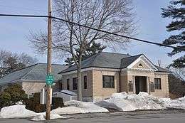
- Lane Memorial Library, Hampton's public library (with town historical information)
- New Hampshire Economic and Labor Market Information Bureau Profile
- Winnacunnet High School