North–South Expressway (Malaysia)
| |
|---|---|
|
[[File: 
North–South Expressway (Malaysia) (Peninsular Malaysia) |290px|alt=]] Route of the North-South Expressway | |
| Route information | |
|
Part of | |
|
Maintained by PLUS Malaysia Berhad with its subsidiary Projek Lebuhraya Usahasama Berhad (Former concessionaries known as Projek Lebuhraya Utara Selatan Berhad (PLUS)) | |
| Length: |
772 km (480 mi) |
| Existed: | 1981[1] – present |
| History: | Completed in 1994[2] |
| Major junctions | |
| North end: | Bukit Kayu Hitam, Kedah |
|
(Penang Second Bridge) | |
| South end: | Johor Bahru, Johor |
| Location | |
| Major cities: | Alor Setar-Butterworth-Ipoh-Kuala Lumpur-Johor Bahru |
| Highway system | |
The North–South Expressway (NSE) (Malay: Lebuhraya Utara-Selatan; Jawi: ليبوهراي اوتارا-سلتن; Chinese: 南北大道, Tamil: வடக்கு-தெற்கு விரைவுசாலை) is the longest controlled-access expressway in Malaysia with the total length of about 772 km (480 mi) running from Bukit Kayu Hitam in Kedah near the Malaysian-Thai border (connects with Phetkasem Road (Route 4) in Thailand) to Johor Bahru at the southern portion of Peninsular Malaysia and to Singapore. The expressway links many major cities and towns in western Peninsular Malaysia, acting as the 'backbone' of the west coast of the peninsula. It is also known as PLUS Expressway, named after the highway's concessionaire, Projek Lebuhraya Utara Selatan Berhad (North South Expressway Project; abbreviated as PLUS. The company has changed its name to Projek Lebuhraya Usahasama Berhad (PLUS), which is a subsidiary of PLUS Malaysia Berhad (PMB).
This expressway passes through 7 states on the peninsula: Johor, Malacca, Negeri Sembilan, Selangor, Perak, Penang and Kedah. It provides a faster alternative to the old Federal Route 1, thus reducing travelling time between various towns & cities. The expressway is part of the Asian Highway Network of route AH2.[3]
Overview
The North-South Expressway is divided into 2 main routes - the northern route (E1) and the southern route (E2). Both routes run in parallel with the Federal Route 1 from Johor Bahru to Bukit Kayu Hitam (except the Simpang Ampat-Yong Peng section to provide an access to Malacca City), where both terminus of the FT1 (Johor Bahru and Bukit Kayu Hitam) serve as the Kilometre Zero of the E2 and E1 respectively, while Kuala Lumpur serves as the final kilometre for both routes. While the E2 ends exactly at the Selangor-Kuala Lumpur border at KM310, the E1 ends at Exit 108 Bukit Lanjan Interchange at KM460 before proceeding to the city via the New Klang Valley Expressway (NKVE), which is also gazetted as Expressway E1. The E1 and E2 expressways are linked together via the North-South Expressway Central Link E6.[4][5]
While most of the expressway was construction according to JKR R6 design standards being defined in the Arahan Teknik 8/86: A Guide on Geometric Design of Roads (controlled-access expressway with design speed limit of 120 km/h and lane width of 3.5 m), the Jitra-Bukit Kayu Hitam section does not adhere to the JKR R6 standards and was grandfathered as part of the E1 expressway, as the section was constructed before the Arahan Teknik 8/86 was published by the Malaysian Public Works Department in 1986.[6]
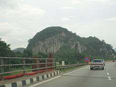 |
 South section of North–south Expressway, facing towards Kuala Lumpur, near Ayer Keroh, Malacca |
 Signs in the expressway |
History
The North-South Expressway was constructed due to the congestion along the Federal Route 1 as a result of the increasing traffic of the FT1. In 1977, the government proposed to build a new north-south divided highway as an alternative to the Federal Route 1, which would be later known as the North-South Expressway E1 and E2.[1] The proposal to build the new highway was mooted as a result of the severe congestion along the Federal Route 1.[6] Because of the large cost of the project, the highway was planned to be privatised and tolled, but none of the constructors being invited by the government were willing to do the job due to economic uncertainties at that time and the plan could not be materialised.[1][6] It was only after Tun Dr. Mahathir Mohamad became the Prime Minister that the North-South Expressway project was revived. The project was launched in 1981.[1]
The Malaysian Highway Authority (MHA) was established on 24 October 1980. The MHA was established to supervise and execute the design, construction, regulation, operation and maintenance of inter-urban highways, to impose and collect tolls, to enter into contracts and to provide for matters connected therewith.[7] At that time, all construction works of the expressway between 1982 and 1988 was solely administered by Malaysian Highway Authority before being transferred to Projek Lebuhraya Utara-Selatan Berhad (PLUS) on 13 May 1988.
The construction of the expressway was done in stages. As the construction works continued, segments of the highway were opened to traffic as they were finished to help fund the construction works. The Jitra-Bukit Kayu Hitam section was constructed as an upgrade of the existing Federal Route 1 section into a divided highway with partial access control and at-grade intersections.[6] At that time, the construction of the Kuala Lumpur-Seremban Expressway E2 was ongoing, and therefore the expressway would later form the pioneer route for the southern route. The Kuala Lumpur-Seremban Expressway E2, which was opened on 16 June 1982, was the first completed section of the North-South Expressway project and became the first expressway to implement the ticket system (closed toll system),[8] then followed by the Jitra-Bukit Kayu Hitam section in 1985.[6] Unlike the other sections of the North-South Expressway, the Jitra-Bukit Kayu Hitam section did not comply with the expressway standards defined by the Arahan Teknik 8/86: A Guide on Geometric Design of Roads which was only published by the Malaysian Public Works Department (JKR) later in 1986, resulting the section to be grandfathered as a part of the North-South Expressway E1.[6]
The third section being opened to motorists was the Seberang Jaya-Prai section. The section was constructed as a part of the Penang Bridge E36 project; hence, the section forms the pioneer route for the Penangite section of the North-South Expressway.[6] The Seberang Jaya-Perai section, together with the Penang Bridge E36, was opened on 14 September 1985.[9]
Meanwhile, the 27.3-km Skudai Highway FT1 was constructed in Johor Bahru as another upgrade of the Federal Route 1 in the south. The toll road had two toll plazas at Senai and at the Johor Causeway.[6] It was constructed by the Malaysian Public Works Department (JKR) before being handed over to Malaysian Highway Authority (LLM) in November 1985.[10] The extensive urbanisation of Johor Bahru however had rendered the Skudai Highway FT1 to be unsuitable to become a part of the North-South Expressway E2, as the Skudai Highway FT1 is not a controlled-access highway. Nevertheless, the toll road and the North-South Expressway were acquired by Projek Lebuhraya Utara-Selatan Berhad]] (PLUS).[6] However, various parties especially residents of Senai and political parties urged that the toll collection be abolished due to the lack of toll-free alternative. As a result, the toll collection at Senai Toll Plaza was abolished on 1 March 2004.[11] After the toll collection at Senai was abolished, the highway had been maintained by the Malaysian Public Works Department.[12] The Johor Causeway Toll Plaza remained in operation until 2008,[6] when the former Johor Bahru CIQ Complex was closed and replaced by the Sultan Iskandar CIQ Complex, and the access to the new CIQ complex and the Johor–Singapore Causeway is provided by the Johor Bahru Eastern Dispersal Link Expressway.
The next completed sections were the Ipoh-Changkat Jering and Senawang-Ayer Keroh sections in 1987.[13][6] The Senawang-Ayer Keroh section was built as an extension of the Kuala Lumpur-Seremban Expressway. The toll collection of the Kuala Lumpur-Seremban Expressway was from Sungai Besi to Labu. As a result of the completion of the Senawang-Ayer Keroh section, the old Labu Toll Plaza was demolished and was replaced by three toll plaza interchanges at Exit 218 Seremban Interchange, Exit 219 Port Dickson Interchange and Exit 220 Senawang Interchange; the Senawang Interchange was constructed by rerouting the through traffic to Ayer Keroh and southwards.[6]
During the initial phases, the North-South Expressway project was criticized for its sluggish progress pace. As of 1986, only about 350 km (or two-third of the entire length) of the expressway was completed.[1] The work progress became worse due to the nationwide economic setback caused by the falling prices of commodities like rubber and tin.[6] As a result, the government had to revise its initial policy of having the Malaysian Highway Authority (LLM) to execute the entire construction job and decided to have the expressway project to be privatised, citing the success of the privatisation of the North Klang Straits Bypass FT20 in 1985 by Shapadu[1] A letter of intention was sent to United Engineers (Malaysia) Sdn. Bhd. (now UEM Group) on 29 December 1986 before being finalised in 1988.[14] The privatisation agreement had led to the formation of Highway Concessionaires Berhad which would later become Projek Lebuhraya Utara-Selatan Berhad (PLUS). PLUS took over the construction, operation and maintenance jobs of the North-South Expressway from LLM starting from March 1998, together with the Skudai Highway FT1.[15]
After the North-South Expressway project was privatised in 1988, the construction work progress continued at a faster pace. The first section completed by PLUS was the Ayer Keroh-Pagoh section on 5 April 1989.[16] Meanwhile, the 31-km New Klang Valley Expressway (NKVE) E1 was opened on 11 January 1993, connecting major cities in the Klang Valley with the North-Soutn Expressway Northern Route.[17] The remaining sections were opened gradually until the entire expressway was fully completed in 1994.
The expressway was officially opened on September 8, 1994 by Malaysian prime minister at that time, Tun Dr. Mahathir bin Mohamad. After the North-South Expressway was completed in 1994, the expressway took the role of the Federal Route 1 as the main backbone route in Peninsular Malaysia.[2]
Monuments
The North-South Expressway Monument was erected at Rawang Rest and Service Area (R&R) (North bound) near Rawang, Selangor on 8 September 1994. A capsule was put in place that contains documents that have been cultivated by the Fourth Prime Minister of Malaysia, Tun Dr Mahathir Mohammad in conjunction with the official opening of the North-South Expressway on 8 September 1994. The capsule will be released after the expiry of the concession of the North-South Expressway by PLUS Expressways on 31 May 2018.
The monument is inscribed on Malay and English. The English version rewards:
"This monument symbolizes the pinnacle of successful for the construction of the North-South Expressway that connects Bukit Kayu Hitam bordering with Thailand in the North to Johor Bahru in the Causeway bordering with Singapore in the South. The construction of the 848km expressway, across the peat swamps and forests and hill untapped granite hills, is an amazing achievement. Also impressive is the pragmatic way in which the combined efforts between the public and private sectors has resulted in this achievement. The expressways is the result of joint efforts of the Malaysian Highway Authority, a statutory body, which has been planned early and begin construction, with the Projek Lebuhraya Utara-Selatan Berhad (PLUS) (North-South Expressway Project), a private company that was awarded concessions to finance, design, construct, operate and maintain the expressways. Such efforts shows an improvement visions into a reality after across a variety of challenges that threaten to stop. It acknowledged the success of the Government and represents a national effort funded and operated successfully by Malaysians. This monument also commemorates the efforts of leaders of the Government, public services, businesses, financial institutions, consultants, engineers and consultants, as well as contractors and labours, which has played an important role in facing their challenges and bring this project to a level of success. Those who use this expressway will be expected not only to enjoy the various parties in the construction efforts, but also can even appreciate this expressway contribution towards national development."
Improvements
Six-lane widening works
Plans to upgrade the stretches from Slim River to Tanjung Malim, Tanjung Malim to Rawang (Northern route), Seremban to Senawang, and Senawang to Ayer Keroh (Southern route) was approved by the government for better traffic flow. It was completed in 2007.
Kuala Lumpur-Penang through traffic (Ipoh North (Jelapang) – Ipoh South)
The Jelapang and Ipoh South toll plazas were demolished in 2009 to make a non-stop route across Ipoh. This is achieved through the construction of two local-express lanes for each side, which are only accessible via Exit 138 Ipoh South Exit (for northbound traffic) and Exit 141 Ipoh North Exit (for southbound traffic). The toll plazas in Ipoh are therefore relocated at each ends of the local-express lanes.
The decision to demolish both toll plazas was made as a result of accidents which happened at Jelapang toll plaza. Since the toll plaza was opened on 28 September 1987, there were many accident cases which involved brake failure in heavy vehicles due to hard braking when proceeding downhill to the toll plaza. On 7 June 2008, the new Ipoh North toll plaza (South bound) replacing old Jelapang toll plaza opened to traffic, followed by north bound on 15 August 2008. Beginning 11:00 am on 14 July 2009, the Kuala Lumpur-Penang through traffic is now opened to traffic. With the opening of the 14.7-kilometre (9.1 mi) between Ipoh North (Jelapang) and Ipoh South stretch, highway users are no longer required to stop for toll transactions at the Ipoh North and Ipoh South Toll Plazas.
Fourth lane additions
On July 2010, the operator PLUS Expressways Berhad announced that the government has awarded contracts to build a fourth lane on certain stretches of the highway, namely from Shah Alam to Jalan Duta, from Shah Alam to Rawang and from Nilai (North) to Port Dickson. On October 2012, the upgrading works for this project began.
Carriageways
Generally the expressway consists of four lanes, two for each direction.
There are some exceptions to this; the following are stretches with six lanes or eight lanes (three or four each way):
Six-lane carriageways
| Highways | Stretches |
|---|---|
| North–South Expressway Southern Route | Sungai Besi to Ayer Keroh (except Nilai North to Port Dickson stretches) |
| New Klang Valley Expressway | Bukit Raja to Shah Alam |
| North–South Expressway Northern Route | Rawang to Slim River |
| North–South Expressway Northern Route | Sungai Dua to Juru located at Penang |
| North–South Expressway Central Link | Shah Alam to Nilai North |
| Second Link Expressway | Pulai to Ayer Rajah Expressway (Tuas, Singapore) |
| Penang Bridge | Prai to Gelugor |
Eight-lane carriageways
| Highways | Stretches |
|---|---|
| North–South Expressway Southern Route | Nilai North to Port Dickson |
| New Klang Valley Expressway | Shah Alam to Jalan Duta |
| North–South Expressway Northern Route | Bukit Lanjan to Rawang |
Speed limit
North–South Expressway is designed as a high-speed long distance expressway therefore the default speed limit on the expressway is 110 km/h (68 mph), but there are some exceptions in some places for several reasons, including:-
- 1 km before every toll plaza: 60 km/h (to help the traffic to slow down)
- Bukit Kayu Hitam-Jitra stretch : 90 km/h (expressway section with at-grade junctions) (Kedah)
- Sungai Dua-Juru : 90 km/h (due to heavy traffic at Penang Bridge) (Penang)
- Kuala Kangsar-Jelapang stretch : 80 km/h (highland stretch with dangerous corners) (Perak)
- Jelapang – Ipoh South stretch : 90 km/h for main carriageways; 70 km/h for toll-free local-express lanes (to control the traffic flow of the non-stop main carriageways and the toll-free local-express lanes) (Perak)
- Gua Tempurung stretch : 90 km/h (highland stretch) (Perak)
- Bukit Lanjan Interchange : 80 km/h (to control traffic flow of NKVE and the main link of northern route to avoid accidents) (Selangor)
- Bukit Lanjan-Jalan Duta stretch : 90 km/h (steep uphill/downhill stretch) (Kuala Lumpur)
- Sungai Besi-Bangi : 90 km/h (due to high traffic capacity) (Kuala Lumpur- Selangor)
Notable incidents
- On August 13, 2007, 20 people were killed in a bus crash near Changkat Jering, Perak.
- On December 7, 2008, 10 passengers were killed in a bus crash at km 146.8 between Tangkak and Pagoh, Johor.
- On 13 April 2009, six people were killed in double decker express bus crash at km 443 near Rawang, Selangor.
- On 26 December 2009, ten passengers were killed and two injured after a northbound double-decker express bus skidded and hit the road divider at Km 272.8 about 8 km from the Ipoh South toll plaza near Ipoh, Perak.
- On 10 October 2010, twelve people were killed and more than 50 others injured in an highway crash involving two buses, three cars and a van at Km 223, near the Simpang Ampat interchange, Malacca.
- On 17 April 2014, lawyer and politician Karpal Singh was killed in a collision between a lorry and the vehicle in which he was travelling from Kuala Lumpur to Penang at Km 306, near Gua Tempurung at Kampar, Perak.
Measures taken to reduce accidents

Most heavy vehicles are only allowed to travel 80–90 km/h by law. Considering that two lanes are inadequate for smooth traffic flow, the expressway is being widened as a result of the increasing number of fatal accidents along this highway.
It has been recently decided that the two-lane 110 km/h highway will be upgraded to a three-lane 110 km/h highway to prevent accidents, however another lane was being added on the selected stretches to increase it to four-lane.
Toll system

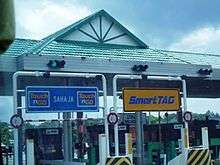
The North–South Expressway is a toll expressway with two toll systems:-
- Open system – Users only have to pay at certain toll plazas within the open system range for a fixed amount. "Open system" is used in the following stretches of the North–South Expressway. (Only Electronic Toll Collection (ETC) such as Touch 'n Go, PLUSMiles and Smart TAG are accepted):
- Batu Tiga and Sungai Rasau, (Selangor)
- Bukit Kayu Hitam, (Kedah)
- Jitra, (Kedah)
- Penang Bridge,
- Kubang Semang (Penang) and Lunas (Kedah)
- Kempas, (Johor)
- Johor-Singapore Causeway,
- Lukut and Mambau, (Negeri Sembilan)
- Tanjung Kupang, Taman Perling and Lima Kedai (Johor).
- Closed system – Users collect toll tickets or PLUSTransit cards before entering the expressway at respective toll plazas and pay an amount of toll at the exit toll plaza plus the distance from the plaza to the Limit of Maintenance Responsibility (LMR). On 18 June 2013, the PLUSTransit reusable transit cards was implemented at all PLUS expressways network to replace the transit ticket. Since 5 April 2016, users have had to use Touch 'n Go, PLUSMiles and SmartTAG in order to enter the expressways.
Toll rates
Toll rate classes for every PLUS Expressways Networks (except Penang Bridge)
| Class | Type of vehicles | Payment | Notes |
|---|---|---|---|
| 0 | Motorcycles (Vehicles with two axles and two wheels) | Free | Except: Tanjung Kupang Toll Plaza (Malaysia-Singapore Second Link) TnG |
| 1 | Private Cars (Vehicles with two axles and three or four wheels (excluding taxi and bus)) | RM (Cash) TnG TAG | |
| 2 | Vans and other small good vehicles (Vehicles with two axles and six wheels (excluding bus)) | RM (Cash) TnG TAG | |
| 3 | Large Trucks (Vehicles with three or more axles (excluding bus)) | RM (Cash) TnG | |
| 4 | Taxis | RM (Cash) TnG | Cash only, paid by passengers only. Except: TnG for: Opened toll systems at all toll plazas |
| 5 | Buses | RM (Cash) TnG |
Toll rate classes for Penang Bridge
| Class | Type of vehicles | Payment | Notes |
|---|---|---|---|
| 1 | Motorcycles, bicycles or vehicles with 2 or less wheels | TnG | |
| 2 | Motorcycle with sidecars, cars including station wagon and commercial vehicles on three wheels | TnG TAG | For taxis, toll charges are paid by passengers using Touch 'n Go only. |
| 3 | Lorries, vans and buses with two axles and four wheels | TnG TAG | |
| 4 | Lorries, vans and buses with two axles and five and six wheels | TnG | |
| 5 | Vehicles with three axles | TnG | |
| 6 | Vehicles with four axles | TnG | |
| 7 | Vehicles with five or more axles | TnG |


Toll abbreviation
| Abbreviation | Exits | Name of interchanges |
|---|---|---|
| AHT | 244 | Ayer Hitam |
| AKH | 231 | Ayer Keroh |
| ALP | 152 | Alor Pongsu |
| ASS | 177 | Alor Setar South |
| ASU | 178 | Alor Setar North |
| BBR | 153 | Bandar Baharu |
| BDA | 217 | Bandar Ainsdale |
| BDR | 130 | Bidor |
| BGR | 237 | Bukit Gambir |
| BGS | 211 | Bangi |
| BKB | 118 | Bukit Beruntung |
| BKH | 185 | Bukit Kayu Hitam |
| BKM | 150 | Bukit Merah |
| BKR | 101 | Bukit Raja |
| BRG | 124 | Behrang |
| BRT | 166 | Bertam |
| BSP | 606 | Bandar Saujana Putra |
| BTS | 158 | Bukit Tambun (South) |
| BTU | 158 | Bukit Tambun (North) |
| BTT | Batu Tiga | |
| BTR | 119 | Bukit Tagar |
| CKJ | 146 | Changkat Jering |
| DMR | 106 | Damansara |
| EBN | 602 | Ebor North |
| EBS | 602 | Ebor South |
| GPG | 135 | Gopeng |
| GRN | 173 | Gurun |
| HKG | Hutan Kampung | |
| HSB | 114 | Hospital Sungei Buloh |
| IPU | 141 | Ipoh North |
| IPS | 139 | Ipoh South |
| JLD | 111 | Jalan Duta |
| JRU | 160 | Juru |
| JSN | 233 | Jasin |
| JTR | 182 | Jitra |
| JWI | 156 | Jawi |
| KDR | 107 | Kota Damansara |
| KJG | 210 | Kajang |
| KKS | 143 | Kuala Kangsar |
| KLA | 608 | KLIA |
| KLI | 252 | Kulai |
| KPS | 255 | Kempas |
| LBB | 120 | Lembah Beringin |
| LKT | 2903 | Lukut |
| MAC | 245 | Machap |
| MBU | 2901 | Mambau |
| NLI | 215 | Nilai |
| PBSB | 161 | Penang Bridge |
| PDG | 175 | Pendang |
| PDN | 219A | Port Dickson North |
| PDS | 219B | Port Dickson South |
| PGH | 238 | Pagoh |
| PLI | 223 | Pedas/Linggi |
| PPM | 213 | Putra Mahkota |
| PSR | 126 | Slim River |
| PTH | 605 | Putra Heights |
| PTJ | 607 | Putrajaya |
| RAW | 116 | Rawang |
| RWS | 115 | Rawang South |
| SAT | 227 | Simpang Ampat (Alor Gajah) |
| SBG | 104 | Subang |
| SBI | Sungai Besi | |
| SBN | 218 | Seremban |
| SBY | 117 | Sungai Buaya |
| SDK | 250 | Sedenak |
| SEA | 603 | Seafield |
| SGB | 113 | Sungai Buloh |
| SGD | 165 | Sungai Dua |
| SGR | Sungai Rasau | |
| SHA | 103/601 | Shah Alam |
| SKD | 254 | Skudai |
| SKI | 128 | Sungkai |
| SVC | 212 | Southville City |
| SNU | 253 | Senai North |
| SPP | 137 | Simpang Pulai |
| SPR | 247 | Simpang Renggam |
| SPS | 168 | Sungai Petani South |
| SPU | 170 | Sungai Petani North |
| STA | 244 | Setia Alam |
| SWG | 220 | Senawang |
| TGK | 235 | Tangkak |
| TGM | 121 | Tanjung Malim |
| TPH | 132 | Tapah |
| TPU | 148 | Taiping North |
| TBN | 138 | Tambun |
| TLK | Lima Kedai | |
| TTK | Tanjung Kupang | |
| TTP | Perling | |
| UPM | 209 | UPM |
| USJ | 604 | USJ |
| YPS | 242 | Yong Peng South |
| YPU | 241 | Yong Peng North |
Facilities along the expressway
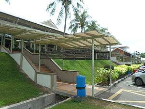
- Rest and service areas located about 60 km from each other
- Layby parking areas are located approximately every two junctions
- Emergency phones every 2 km
- PLUSLINE hotline number
- PLUS Ronda (PLUS patrol) service to assist drivers in the event of vehicle problems on the expressway
- PLUS helicopter patrol unit to monitor PLUS expressways
Records
- North–South Expressway is Malaysia's first long-distance expressway as well as Malaysia's longest expressway.
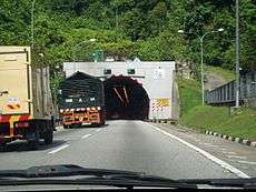
- Menora Tunnel, an 800 m (2,600 ft) tunnel on the North–South Expressway Northern Route near Jelapang, was once Malaysia's longest highway tunnel at the time of its construction.
- The largest toll plaza in Malaysia is Bandar Cassia-PLUS Toll Plaza (Gateway Arch Toll Plaza) in Penang Second Bridge E28 with over 28 lanes (excluding additional motorcycle toll plaza). The second largest toll plaza is Sungai Besi Toll Plaza in North-South Expressway Southern Route E2 with over 18 lanes (excluding additional toll booths).
- The longest bridge along the expressway is Sungai Perak Bridge (Jambatan Sultan Azlan Shah) with the length of 300 m (980 ft).
- The first Rest and Service Area on the North-South Expressway is the Ayer Keroh Rest and Service Area in the North–South Expressway Southern Route opened in 1987.
- North–South Expressway is the first expressway in Malaysia that provides overhead bridge restaurants.
- The longest flyover bridge along the NSE network is Batu Tiga flyover in the North–South Expressway Central Link.
- The most expensive section of the expressway is the Gopeng-Tapah section. At RM200 million, it cost any average of RM 20 million per kilometre. Embankment strengthening is the major contributor for this escalating cost.
- The longest stretch of the North-South Expressway network is the Pagoh-Yong Peng (North) section. This 47 kilometre stretch passing Mount Maokil and the plains of Seri Medan and Sungai Sarang Buaya.
- The PLUS Speedway (formerly ELITE Speedway) in USJ Rest and Service Area on North–South Expressway Central Link is the first highway go-kart circuit in Malaysia.
- North–South Expressway forms 80% of Malaysian part of the Asian Highway Network, specifically Asian Highway Network 2 AH2. The other expressways in Malaysia included in the route are Johor Bahru Eastern Dispersal Link Expressway and Johor Causeway.
- The Nilai Memorial Park near Nilai Layby on North–South Expressway Southern Route is the first closed tolled expressway public memorial park in Malaysia.
- The PLUS Art Gallery in Ayer Keroh Overhead Bridge Restaurant (OBR) is the first highway art gallery in Malaysia.
- Kempas Highway (Johor State Route J3) is the only state route ever built by an expressway concessionaire company (PLUS Expressway Berhad).
- The Machap Rest and Service Area (northbound) at the North–South Expressway Southern Route
 is the first fully air-conditioned rest area in Malaysia, after it was renovated during mid-2008.
 - The Sungai Perak Rest and Service Area (southbound) at the North–South Expressway Northern Route E1 in Perak is the first rest and service area in the Malaysian expressway to have an eco-management theme known as "The Green Trail" or "Jejak Hijau".
- PLUSMiles is the first and only toll rebate loyalty programme in the Malaysian expressways.
- The longest closed toll collection system coverage in Malaysia is from Juru toll plaza to Skudai toll plaza (previously Ipoh South toll plaza to Skudai toll plaza), which runs through the North–South Expressway Northern Route E1, New Klang Valley Expressway E1, North–South Expressway Central Link E6 and North–South Expressway Southern Route E2.
- The North–South Expressway Northern Route E1 is the only expressway in Malaysia to have a runaway truck ramp near Jelapang, Ipoh.
List of interchanges
- See also

 North–South Expressway Northern Route
- North–South Expressway Southern Route
-
 New Klang Valley Expressway
  North–South Expressway Central Link
 Second Link Expressway
 Seremban-Port Dickson Highway

 Butterworth-Kulim Expressway
 Penang Bridge
Commemorative Events
The North-South Expressway commemorative postage stamps
The commemorative postage stamps to mark the opening of the North-South Expressway on 1994 were issued by Pos Malaysia on 10 September 1994. The denominations for these stamps were 30 cents, 50 cents, and RM 1.00.
See also
- Malaysian Expressway System
- Malaysia Federal Route 1 - the toll-free north-south federal highway that runs in parallel with the North-South Expressway
Notes
- 1 2 3 4 5 6 Roads in Malaysia. Kuala Lumpur: Malaysian Ministry of Works. 2011. p. 204. ISBN 978-967-5399-17-6.
- 1 2 "Perasmian Penyempurnaan Lebuhraya Utara-Selatan". Hari Ini Dalam Sejarah. National Archives of Malaysia. 8 October 1994. Retrieved 31 May 2015.
- ↑ "Asian Highway Database: AH Network in Member Countries". United Nations Economic and Social Commission for Asia and the Pacific. Archived from the original on 25 January 2013. Retrieved 19 September 2015.
- ↑ Inventori Rangkaian Jalan Utama Persekutuan Semenanjung Malaysia. Kuala Lumpur: Malaysian Ministry of Works. 2009. pp. 58–64. ISBN 978-983-44278-2-5.
- ↑ "Our Expressways: North-South Expressway (NSE)". PLUS Malaysia Berhad. Retrieved 19 September 2015.
- 1 2 3 4 5 6 7 8 9 10 11 12 13 "Sejarah lengkap Lebuhraya Utara-Selatan E1 dan E2". Blog Jalan Raya Malaysia (in Malay). 20 April 2015. Retrieved 31 May 2015.
- ↑ "Corporate Info: Background". Malaysian Highway Authority. Retrieved 19 September 2015.
- ↑ "Pembukaan Plaza Tol Lebuhraya Kuala Lumpur-Seremban". Hari Ini Dalam Sejarah. National Archives of Malaysia. 16 June 1982. Retrieved 31 May 2015.
- ↑ "Jambatan Pulau Pinang Dirasmikan". Hari Ini Dalam Sejarah. National Archives of Malaysia. 14 September 1985. Retrieved 31 May 2015.
- ↑ "Perasmian Penutupan Plaza Tol Senai, Lebuh Raya Senai-Tampoi". Hari Ini Dalam Sejarah. National Archives of Malaysia. 1 March 2004. Retrieved 31 May 2015.
- ↑ "Plaza tol Senai akhiri operasi" (in Malay). Utusan Malaysia. 1 March 2004. Retrieved 20 September 2015.
- ↑ "Penduduk gembira Tol Senai ditutup" (in Malay). Utusan Malaysia. 2 March 2004. Retrieved 20 September 2015.
- ↑ "Pembukaan Rasmi Lebuh Raya Ipoh-Changkat Jering". Hari Ini Dalam Sejarah. National Archives of Malaysia. 28 September 1987. Retrieved 31 May 2015.
- ↑ "UEM Tandatangani Perjanjian Dengan JKR Untuk Pembinaan Lebuhraya Utara-Selatan". Hari Ini Dalam Sejarah. National Archives of Malaysia. 29 December 1986. Retrieved 31 May 2015.
- ↑ "Subsidiaries: Projek Lebuhraya Utara-Selatan Berhad". PLUS Malaysia Berhad. Retrieved 19 September 2015.
- ↑ "Perasmian Lebuhraya Ayer Keroh-Pagoh". Hari Ini Dalam Sejarah. National Archives of Malaysia. 5 April 1989. Retrieved 24 September 2015.
- ↑ "Perasmian Lebuhraya Baru Lembah Klang". Hari Ini Dalam Sejarah. National Archives of Malaysia. 11 January 1993. Retrieved 24 September 2015.