Norway, New York
| Norway, New York | |
|---|---|
| Town | |
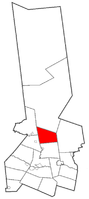 Location within Herkimer County | |
 Norway, New York Location within the state of New York | |
| Coordinates: 43°12′45″N 74°57′20″W / 43.21250°N 74.95556°W | |
| Country | United States |
| State | New York |
| County | Herkimer |
| Government | |
| • Type | Town Council |
| • Town Supervisor | Judith Gokey (R) |
| • Town Council |
Members' List
|
| Area | |
| • Total | 35.9 sq mi (92.9 km2) |
| • Land | 35.6 sq mi (92.2 km2) |
| • Water | 0.3 sq mi (0.7 km2) |
| Elevation | 1,526 ft (465 m) |
| Population (2010) | |
| • Total | 762 |
| Time zone | Eastern (EST) (UTC-5) |
| • Summer (DST) | EDT (UTC-4) |
| FIPS code | 36-53968 |
| GNIS feature ID | 0979295 |
Norway is a town in Herkimer County, New York, United States. The population was 762 at the 2010 census.
The Town of Norway is located in the east-central part of the county and is northeast of Utica.
The town borders the Adirondack Park.
History
The town was permanently settled around 1787 after an abandoned effort in 1786.
Norway was formed in 1792 immediately after the creation of Herkimer County. Norway was originally a very large town, and it was subsequently broken up, directly or indirectly, into about thirty-six new towns in several bordering counties. In Herkimer County, the Towns of Fairfield (1796), Russia (1806), Ohio (1823), Wilmurt (now defunct), and Webb (1836) were made by dividing Norway. Part of Newport was taken from Norway in 1806. The creation of Oneida County, Lewis County, Clinton County, Hamilton County, and St. Lawrence County from Herkimer County accounts for the remaining towns derived from Norway.
In 1825, the town's population was 1,168.
Because of poor soil conditions, early farmers eventually turned to raising dairy herds. By 1887, there were six cheese factories in Norway.
The Norway Baptist Church (former) was added to the National Register of Historic Places in 2007.[1]
Geography
According to the United States Census Bureau, the town has a total area of 35.9 square miles (93 km2), of which, 35.6 square miles (92 km2) of it is land and 0.3 square miles (0.78 km2) of it (0.72%) is water.
New York State Route 8 crosses the northwest part of Norway.
Demographics
| Historical population | |||
|---|---|---|---|
| Census | Pop. | %± | |
| 1820 | 1,613 | — | |
| 1830 | 1,152 | −28.6% | |
| 1840 | 1,046 | −9.2% | |
| 1850 | 1,052 | 0.6% | |
| 1860 | 1,105 | 5.0% | |
| 1870 | 1,117 | 1.1% | |
| 1880 | 1,045 | −6.4% | |
| 1890 | 818 | −21.7% | |
| 1900 | 680 | −16.9% | |
| 1910 | 642 | −5.6% | |
| 1920 | 488 | −24.0% | |
| 1930 | 482 | −1.2% | |
| 1940 | 386 | −19.9% | |
| 1950 | 447 | 15.8% | |
| 1960 | 427 | −4.5% | |
| 1970 | 605 | 41.7% | |
| 1980 | 662 | 9.4% | |
| 1990 | 663 | 0.2% | |
| 2000 | 711 | 7.2% | |
| 2010 | 762 | 7.2% | |
| Est. 2014 | 781 | [2] | 2.5% |
As of the census[4] of 2000, there were 711 people, 247 households, and 185 families residing in the town. The population density was 20.0 people per square mile (7.7/km²). There were 311 housing units at an average density of 8.7 per square mile (3.4/km²). The racial makeup of the town was 99.02% White, 0.14% Asian, and 0.84% from two or more races. Hispanic or Latino of any race were 0.42% of the population.
There were 247 households out of which 34.0% had children under the age of 18 living with them, 59.5% were married couples living together, 9.7% had a female householder with no husband present, and 25.1% were non-families. 19.0% of all households were made up of individuals and 4.5% had someone living alone who was 65 years of age or older. The average household size was 2.88 and the average family size was 3.21.
In the town the population was spread out with 27.6% under the age of 18, 9.0% from 18 to 24, 28.6% from 25 to 44, 27.7% from 45 to 64, and 7.2% who were 65 years of age or older. The median age was 36 years. For every 100 females there were 116.8 males. For every 100 females age 18 and over, there were 116.4 males.
The median income for a household in the town was $36,719, and the median income for a family was $41,250. Males had a median income of $29,375 versus $23,846 for females. The per capita income for the town was $15,396. About 6.3% of families and 10.1% of the population were below the poverty line, including 17.3% of those under age 18 and 8.3% of those age 65 or over.
Notable residents
- David Legge Brainard, United States Army officer and explorer
- Charles S. Millington, politician
- George R. Vincent, politician
Communities and locations in Norway, NY
- Black Creek Reservoir – A reservoir in the north part of the town.
- Dairy Hill – An elevation in the southeast part of the town.
- Gray – A hamlet near the north town line on County Road 48.
- Hurricane – A hamlet in the northwest part of the town on NY-8.
- Norway – The hamlet of Norway is near the center of the town.
References
- ↑ National Park Service (2009-03-13). "National Register Information System". National Register of Historic Places. National Park Service.
- ↑ "Annual Estimates of the Resident Population for Incorporated Places: April 1, 2010 to July 1, 2014". Retrieved June 4, 2015.
- ↑ "Census of Population and Housing". Census.gov. Retrieved June 4, 2015.
- ↑ "American FactFinder". United States Census Bureau. Retrieved 2008-01-31.
External links
Coordinates: 43°12′30″N 74°57′08″W / 43.20833°N 74.95222°W
Municipalities and communities of Herkimer County, New York, United States | ||
|---|---|---|
| City | 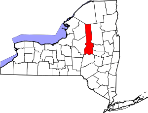 | |
| Towns | ||
| Villages | ||
| CDP | ||
| Hamlets | ||
| Footnotes | ‡This populated place also has portions in an adjacent county or counties | |