Notasulga, Alabama
| Notasulga, Alabama | |
|---|---|
| Town | |
 | |
 Location in Lee County & Macon County, Alabama | |
| Coordinates: 32°33′39″N 85°40′3″W / 32.56083°N 85.66750°W | |
| Country | United States |
| State | Alabama |
| Counties | Macon, Lee |
| Area | |
| • Total | 14 sq mi (36.1 km2) |
| • Land | 13.9 sq mi (36 km2) |
| • Water | 0.1 sq mi (0.1 km2) |
| Elevation | 512 ft (512 m) |
| Population (2010) | |
| • Total | 965 |
| Time zone | CST (UTC-6) |
| • Summer (DST) | CDT (UTC-5) |
| ZIP code | 36866 |
| Area code(s) | 334 |
| FIPS code | 01-55440 |
| GNIS feature ID | 0152715 |
Notasulga is a town in Lee and Macon counties in the U.S. state of Alabama. As of the 2010 census, the population of the town was 965, up from 916 in 2000. The portion in Lee County is part of the Auburn Metropolitan Area. According to the 2010 U.S. Census, it incorporated in 1893.[1] Author Zora Neale Hurston was born in Notasulga in 1891.
Geography
Notasulga is located at 32°33′39″N 85°40′3″W / 32.56083°N 85.66750°W (32.560821, -85.667631).[2]
According to the U.S. Census Bureau, the town has a total area of 14 square miles (36 km2), of which 13.9 square miles (36 km2) is land and 0.1 square miles (0.26 km2) (0.43%) is water.
Demographics
| Historical population | |||
|---|---|---|---|
| Census | Pop. | %± | |
| 1880 | 236 | — | |
| 1890 | 332 | 40.7% | |
| 1910 | 512 | — | |
| 1920 | 619 | 20.9% | |
| 1930 | 756 | 22.1% | |
| 1940 | 863 | 14.2% | |
| 1950 | 816 | −5.4% | |
| 1960 | 884 | 8.3% | |
| 1970 | 833 | −5.8% | |
| 1980 | 876 | 5.2% | |
| 1990 | 979 | 11.8% | |
| 2000 | 916 | −6.4% | |
| 2010 | 965 | 5.3% | |
| Est. 2015 | 856 | [3] | −11.3% |
| U.S. Decennial Census[4] 2013 Estimate[5] | |||
As of the census[6] of 2000, there were 916 people, 393 households, and 260 families residing in the town. The population density was 65.9 people per square mile (25.4/km²). There were 446 housing units at an average density of 32.1 per square mile (12.4/km²). The racial makeup of the town was 66.27% White, 32.42% Black or African American, 0.22% Native American, 0.55% from other races, and 0.55% from two or more races. 0.76% of the population were Hispanic or Latino of any race.
There were 393 households out of which 26.2% had children under the age of 18 living with them, 48.6% were married couples living together, 14.0% had a female householder with no husband present, and 33.6% were non-families. 29.5% of all households were made up of individuals and 11.5% had someone living alone who was 65 years of age or older. The average household size was 2.33 and the average family size was 2.87.
In the town the population was spread out with 23.4% under the age of 18, 7.8% from 18 to 24, 24.8% from 25 to 44, 28.2% from 45 to 64, and 15.9% who were 65 years of age or older. The median age was 40 years. For every 100 females there were 86.6 males. For every 100 females age 18 and over, there were 81.9 males.
The median income for a household in the town was $31,307, and the median income for a family was $34,479. Males had a median income of $27,500 versus $18,684 for females. The per capita income for the town was $17,115. About 10.7% of families and 17.8% of the population were below the poverty line, including 20.8% of those under age 18 and 11.2% of those age 65 or over.
Government

Notasulga elects a mayor and five city council members every four years.
2012 Mayor and Council:
- Mayor - Tommy Miller
- Council District 1 - Cecil R. Langford, Jr.
- Council District 2 - Terry Broach
- Council District 3 - Cline Carmack
- Council District 4 - Scott Barnhart
- Council District 5 - Robin Collins
- Police Chief - Michael Knowles
- Fire Chief - Michael Whitman
- Superintendent - Tony McCarty
Notable people
- Valerie Boyd, journalist, author and cultural critic
- Pat Dye, former American football player, coach, and college athletics administrator. He served as the head football coach at East Carolina University (1974–1979), the University of Wyoming (1980), and Auburn University (1981–1992) compiling a career college football record of 153–62–5. He served as the athletic director at Auburn from 1981–91 and was inducted into the College Football Hall of Fame as a coach in 2005.
- John K. Hodnette, electrical engineer at the Westinghouse Electric Corporation who was awarded the IEEE Edison Medal in 1957
- Zora Neale Hurston, anthropologist, novelist[7]
- J. Ed Livingston, jurist and the Twenty-third Chief Justice of the Alabama Supreme Court from 1951 through 1971
- Gerald Robinson, former National Football League defensive end who played from 1986 to 1994 for the Minnesota Vikings, the San Diego Chargers and the Los Angeles Rams. He attended the Auburn University, is the all-time sack leader at Auburn University.
Photo gallery
 The Shiloh Missionary Baptist Church and Rosenwald School were both used as meeting and testing places for participants in the Tuskegee Syphilis Study (also known as the "Tuskegee Experiments"). The buildings are located in Notasulga, and both are listed on the National Register of Historic Places.
 The Shiloh-Rosenwald School
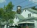 One of the historic homes near Downtown Notasulga
 Old water tower located across from the Methodist church in Notasulga
 The Notasulga Water Works
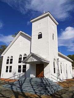
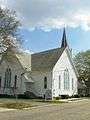 Notasulga United Methodist Church
References
- ↑ https://books.google.com/books?id=GNREAAAAYAAJ&pg=PA581&lpg=PA581&dq=%22hardaway%22+%22incorporated%22+%22macon+county%22&source=bl&ots=raRinQH7Pw&sig=9VAdqu_ho5eS9RTruFurcpnFzGI&hl=en&sa=X&ved=0ahUKEwia-Lzm4_XKAhWIOSYKHddIC8EQ6AEIRzAI#v=onepage&q=%22hardaway%22%20%22incorporated%22%20%22macon%20county%22&f=false
- ↑ "US Gazetteer files: 2010, 2000, and 1990". United States Census Bureau. 2011-02-12. Retrieved 2011-04-23.
- ↑ "Annual Estimates of the Resident Population for Incorporated Places: April 1, 2010 to July 1, 2015". Retrieved July 2, 2016.
- ↑ "U.S. Decennial Census". Census.gov. Retrieved June 6, 2013.
- ↑ "Annual Estimates of the Resident Population: April 1, 2010 to July 1, 2013". Retrieved June 3, 2014.
- ↑ "American FactFinder". United States Census Bureau. Retrieved 2008-01-31.
- ↑ Valerie Boyd (4 October 2011). Wrapped in Rainbows: The Life of Zora Neale Hurston. Simon and Schuster. p. 19. ISBN 978-1-4391-2541-0.
Coordinates: 32°33′39″N 85°40′03″W / 32.560821°N 85.667631°W
Municipalities and communities of Lee County, Alabama, United States | ||
|---|---|---|
| Cities | 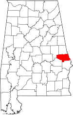 | |
| Towns | ||
| Unincorporated communities | ||
| Footnotes | ‡This populated place also has portions in an adjacent county or counties | |
Municipalities and communities of Macon County, Alabama, United States | ||
|---|---|---|
| City |  | |
| Towns | ||
| Unincorporated communities | ||
| Footnotes | ‡This populated place also has portions in an adjacent county or counties | |
| Central cities/Largest cities |  Location of the Columbus, Georgia-Auburn, Alabama CSA and its counties:
Columbus, Georgia Metropolitan Statistical Area
Auburn, Alabama Metropolitan Statistical Area
Tuskegee, Alabama Micropolitan Statistical Area (defunct) | |
|---|---|---|
| Cities in Georgia | ||
| Cities in Alabama | ||
| Counties in Georgia | ||
| Counties in Alabama | ||