Ohio State Route 119
| ||||
|---|---|---|---|---|
 | ||||
| Route information | ||||
| Maintained by ODOT | ||||
| Length: | 41.94 mi[1] (67.50 km) | |||
| Existed: | 1924 – present | |||
| Major junctions | ||||
| West end: |
| |||
|
| ||||
| East end: |
| |||
| Location | ||||
| Counties: | Mercer, Auglaize, Shelby | |||
| Highway system | ||||
| ||||

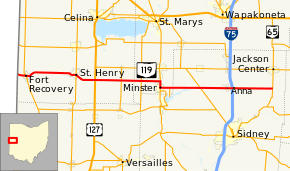
State Route 119 (SR 119) is an east–west highway serving rural sections of west-central Ohio. It begins just west of Fort Recovery at the eastern terminus of Indiana State Road 26. It travels through Mercer, Auglaize County, and Shebly counties to end at SR 65 in Jackson Township, Shelby County. The route is 42-mile-long (68 km) and serves the medium-size villages of Fort Recovery, St. Henry, Minster, and Anna.
Route description
SR 119 begins at the Indiana–Ohio border about 1 mile (1.6 km) west of Fort Recovery. At this point State Line Road runs north and south along the border while the highway continues west as Indiana State Road 26 towards Portland, Indiana. After immediately crossing an R.J. Corman Railroad Group rail line, SR 119 travels east into Fort Recovery on Butler Avenue. In the center of the village, SR 119 intersects SR 49. Further east in the village, the route follows Boundary Street and sharply curves to the northeast to cross the Wabash River near its mouth. The road curves to the due east and travels through farmland before making a reverse curve to the south to enter St. Henry. Passing through the town on Western Avenue and Main Street, SR 119 intersects SR 118 near the village's eastern border. After making one more diagonal cut to the southeast, SR 119 again travels due east through the farmland of Mercer County. After intersecting U.S. Route 127, the highway passes through numerous unincorporated communities in an area known as the Land of the Cross-Tipped Churches. Examples of such communities and churches include Cassella's Nativity of the Blessed Virgin Mary Catholic Church and Maria Stein's St. John the Baptist Catholic Church, respectively. In Maria Stein, SR 119 intersects SR 716.[2]
The road crosses into the southern panhandle of Auglaize County, specifically Jackson Township. At first, the route heads through rural farmland, similar to how it traveled through Mercer County. It intersects SR 364 near the western border of the county but then travels along the northern border of Minster before forming a 1-mile-long (1.6 km) concurrency with SR 66 towards the south. In downtown Minster, the two roads follow Main Street and pass the campus of Minster High School. In the center of the village's business district, SR 119 splits from the SR 66 concurrency at Fourth Street and travels due east again. East of the village limits, the route intersects SR 363, a short spur route to the shoreline of Lake Loramie and its namesake state park. The road enters Shelby County, passes over Loramie Creek, and enters the unincorporated community of McCartyville where it has a skewed intersection with SR 29. SR 119 passes through the village of Anna where it intersects Market Street, the former routing of U.S. Route 25 and Dixie Highway. On the east side of the village, it has an interchange with Interstate 75 at its exit 99. In the immediate vicinity of the interchange, numerous fast food restaurants, gas stations, and truck stops are found. East of the interchange, the road continues for seven miles (11 km) through rural farmland before terminating at a T-intersection with SR 65, about halfway between SR 65's terminus and Jackson Center.[2]
History
The SR 119 designation was created in 1923 following what is now its current route from the Indiana border to SR 29 in Shelby County.[3] The designation was overlaid on existing State Highways 171 and 172 which had been under state control since the initial designation of highways in 1912.[4][5] In 1937, SR 119 was extended east to SR 65, its present terminus.[6][7] No major changes to SR 119's alignment have occurred since then.
Major intersections
| County | Location | mi[1] | km | Destinations | Notes |
|---|---|---|---|---|---|
| Mercer | Recovery Township | 0.00 | 0.00 | Indiana state line | |
| Fort Recovery | 1.50 | 2.41 | |||
| St. Henry | 9.62 | 15.48 | |||
| Granville–Marion township line | 12.89 | 20.74 | |||
| Marion Township | 17.02 | 27.39 | |||
| Auglaize | Jackson Township | 20.17 | 32.46 | ||
| Minster | 23.19 | 37.32 | Western end of SR 66 concurrency | ||
| 24.20 | 38.95 | Eastern end of SR 66 concurrency | |||
| Jackson Township | 25.71 | 41.38 | Northern terminus of SR 363 | ||
| Shelby | Van Buren Township | 30.53 | 49.13 | ||
| Franklin–Dinsmore township line | 35.52– 35.66 | 57.16– 57.39 | Exit 99 (I-75) | ||
| Jackson Township | 41.94 | 67.50 | |||
1.000 mi = 1.609 km; 1.000 km = 0.621 mi
| |||||
References
- 1 2 "DESTAPE". Ohio Department of Transportation. July 3, 2014. Retrieved September 9, 2014.
- 1 2 Google (December 31, 2015). "Ohio State Route 119" (Map). Google Maps. Google. Retrieved December 31, 2015.
- ↑ Map of Ohio Showing State Routes (MrSID) (Map). Cartography by L.A. Boulay, Director. Ohio Division of Highways. 1923. Retrieved August 18, 2013.
- ↑ Map of Ohio Showing Inter-County Highways (MrSID) (Map). Cartography by James R. Marker, State Highway Commissioner. Ohio State Highway Department. 1912. Retrieved August 18, 2013.
- ↑ Map of Ohio State Highways Showing All Improved Roadways (MrSID) (Map). Cartography by E.C. Blosser. Ohio Department of Highways and Public Works. 1922. Retrieved August 18, 2013.
- ↑ 1936 Official Highway Map (MrSID) (Map). Cartography by John Jaster, Jr., Director. ODOH. 1936. Retrieved August 19, 2013.
- ↑ Official Ohio Highway Map 1937 (MrSID) (Map). Cartography by John Jaster, Jr., Director. ODOH. 1937. Retrieved August 19, 2013.
External links
 Media related to Ohio State Route 119 at Wikimedia Commons