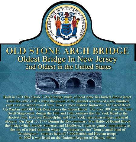
Old Stone Arch Bridge (Bound Brook, New Jersey)
|
Old Stone Arch Bridge | |
|
Old Stone Arch Bridge | |
   | |
| Location |
Railroad Avenue, approximately 194 feet east of South Main Street Bound Brook, New Jersey |
|---|---|
| Coordinates | 40°33′38″N 74°31′37″W / 40.56056°N 74.52694°WCoordinates: 40°33′38″N 74°31′37″W / 40.56056°N 74.52694°W |
| Area | less than one acre |
| Built | 1730 |
| Architectural style | Stone Arch bridge |
| NRHP Reference # | 08000550[1] |
| NJRHP # | 4773[2] |
| Significant dates | |
| Added to NRHP | June 27, 2008 |
| Designated NJRHP | May 7, 2008 |
The Old Stone Arch Bridge is the second-oldest extant bridge in the United States following Pennypack Creek Bridge (also called the Frankford Avenue Bridge (built in 1697) [3] in North Philadelphia, Pennsylvania. It is the oldest bridge in New Jersey having been placed on the National Register of Historic Places in 2008.
The Old Stone Arch Bridge was built in 1731 spanning the Green Brook, connecting Bound Brook (Middlesex County) and Middlesex Borough (Somerset County) in north central, New Jersey and carried the Great Road Up Raritan laid out in 1681 that was created by an act of the Assembly of the province of East Jersey.[4] In 1764 the colonial highway, west to what is now Lambertville on The Delaware River and east to Elizabethtown Point on Newark Bay was christened Old York Road, This highway was the shortest route between Philadelphia and New York City (reached by ferry), the two most populous cities in the United States through the late 18th century. It was built shortly after the Kings Highway called a variety of names, but most prominently when the old Indian path, the Assunpink Trail was widened and only slightly improved, the Upper Road..[5] The bridge allowed farmers, plantation owners and everyone else west and north of the Raritan River a direct and practical route to the colonial ports of New Brunswick and Raritan Landing. Since the early 1870s the Old Stone Arch Bridge has been buried up to the parapets (stone walls along the roadway) due to construction of a railroad embankment.
Description
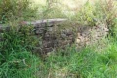
The bridge made from rough-hewn masonry and stone which is believed to be locally quarried is a classic, 3-arch edifice. The center span is about 17.9' and two side arches are about 12'6" (west) and 12'3 (east). The roadway between the exposed south and not visible north parapet which might at some point have been widened is about 26'. It has an overall length of about 79'6', making it even longer than the famous Pennypack Creek Bridge. Currently only the south parapet and a varying sized spandrel, 4' in the center and 6' at each end is visible. This is believed to indicate originally before the roadway was flattened out, it was a typical humpback or camelback bridge, typical of the day.[6] A concrete barrier like those used to on many highways was installed several years ago to protect the south parapet.[6] Only an obscure sign, often hidden behind weeds and wild bushes and large trucks and trailers that park alongside it identifies what lies beneath.
Endangered status
The bridge having been buried for over 140 years is listed by ‘’Preservation New Jersey’’ as one of the “10 Most Endangered Historic Sites in New Jersey.[7] However as explained below, Somerset County which has assumed responsibility for the structure has invested almost $100,000 according to its Cultural and Heritage Commission [8] with full cooperation from its neighboring Middlesex County Cultural and Heritage Commission [9] to unearth and restore the states most historic bridge.
Communities
The center of bridge is the border between Somerset and Middlesex Counties and the communities within those counties of Bound Brook and Middlesex Boroughs.[10] In 1731 Bound Brook Borough was part of Bridgewater [11] and Middlesex Borough Part of Piscataway.[12]
Byways that crossed the bridge
Today’s SR 27 and 206 south of Princeton, NJ was the first road in northern New Jersey. It originally extended to Salem, NJ and was designated "Old Salem Road." This portion of the original road still carries that name. It was known by various other names including the first, the Indian "Asapink Trial (or Path)," "Upper Road," "Old Dutch Road" and in "Lincoln Highway" The second highway was Camden and Amboy Turnpike with portions of today’s Cranbury Road were the first three important highways in the New Jersey. It was original known as "Lawrie's Road" or "Lower Road.", the third one was what is a portion of today’s River Road that extends from Piscataway to Bound Brook.[13] Until about the time of the Revolutionary War, River Road was not a significant highway, but portions of it veered northeast to present day Dunellen, originally known as Quibble Town and then New Market as the ‘’Great Road Up Raritan’’ which then turned west and continued southwest to the point where it crossed the Old Stone Arch Bridge and then proceeded through Bound Brook and west roughly along the north bank of the Raritan River to point where the river divides into its north and south branches in appropriately named Branchburg. From there it followed a variety of existing roads southwest toward the Delaware River.;[14][15] Further evidence that the highway was known by that name was provided in 1936 by Cornelius C. Vermeule in his ‘’Raritan Landing That Was’’, 1675-1875 (1936) which provided an road map he, a local historian born and bred in Raritan Landing (see below) drew to recreate the route).[16]
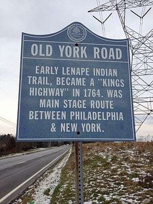
Starting in Cheltenham, Pennsylvania north of Philadelphia as early as the late 17th century groundswell began to build a highway from that City of Brotherly Love to New Hope on the Delaware River across from one of the major ferry’s to New Jersey at Coryell’s Ferry (now Lambertville)[17] The highway was conceived by a petition to Governor Charles Gookin and his Council in 1691 by the Cheltenham, Pennsylvania settlers that a road be built between “the river Delaware to the City of Philadelphia,” that resulted in a survey being done in 1711[18] From 1711 to 1772 it was constructed and ran from Central Philadelphia to Elizabethtown (now Elizabeth) Point. It was known as Old York Road. The main road still exists under a variety of other names, but a large portion still has that name in Pennsylvania and New Jersey from Lambertville to Hillsborough as it crossed SR 206[19] It was formally accepted and authorized after a 1762 Road Survey conducted by Somerset County that ended with its eastern terminus in that county as ‘’to middle of Bound Brook Stone Bridge’’ [20]
Being the shortest route from Philadelphia to New York City, Old York Road was selected by the Swift Sure Stagecoach line that was granted a franchise by the two states [21] It ran well into the middle of the 19th century until the rise of the railroads made all stage coach travel obsolete. The ‘’Old Stage Inn’’ on Front Street and Park Avenue in Scotch Plains, New Jersey, built in 1737 was one of the original taverns and stage coach stops, also called ‘’ordinaries’’ where mail was dropped off and passengers could stop, eat and get refreshed and even spend the night. It is still in business in much of its historic ambiance as a popular restaurant just south of U.S. 22. A memorial marker sits on a small boulder next to a flagpole on Front Street just in front of the inn.
Crossing the waterways
The first bridges in New Jersey in colonial days were a few logs dropped across a stream with sawn timbers fastened to them to provide a flat, relatively even surface. Occasionally a handrail was added on one side for safety. Most were funded by local municipalities.[13][22]
Today in New Jersey, almost exclusively in the central and northern portions of the state in or close to mountainous terrain where the stone is abundance, stone arch bridges that still exist number in the hundreds and probably thousands. Most were built between the 1820s and the turn of the century. (There are few in the southern portions of the state, probably because it was less congested and traveled and because there was not the natural stone available in the north.)
Need to bring goods to market … impact of Raritan Landing
The Old Stone Arch Bridge needed to be built in the first place for no greater reason than the fact the Green Brook presented an uncrossable obstacle for hunters, farmers, tradesmen and all other travelers between northwest New Jersey and all points west who chose to follow the major east-west river in the state.
In the early 18th century traveling along the northern bank of the Raritan westward from Somerset County required crossing the Green Brook which divided above its confluence with the Raritan River it from Middlesex County. Unlike many other rivers and waterway crossings in the colonies and New Jersey in particular there was no established ferry. So it was literally impossible to cross the brook without taking an extremely long and time-consuming northern bypass. This became particularly a problem because of the emergence of the ports of New Brunswick and Raritan Landing across from each other on the river.
Raritan Landing emerged as a vital port community during the 1720s. It was situated at the farthest inland point on the Raritan River that could be navigated by merchant ships of the day. In its heyday, the Landing was the center for local trade and, along with New Brunswick, served as a hub for imports and exports to and from the Raritan Valley. By the 1740s, there were approximately 70 structures and more than 100 inhabitants. By the end of the Revolutionary War it had become insignificant, after being ravished by the invading British armies and overshadowed by New Brunswick where the river was deeper.[23]
Old Stone Bridge, buried for 140 years
The Old Stone Arch Bridge is obscurely located along what is no more than a rough road driveway to a warehouse occupied by trucking company. The third oldest -span stone arch bridge that carries the historic Kings Highway over Stony Brook between Princeton and Lawrenceville was built in 1792, and although after the colonial era, it is part of an early and important regional thoroughfare.
Thomas D’Amico, Historical Site Coordinator for the Somerset County Cultural and Heritage Commission and his commission and the county’ Board of Chosen Freeholders commissioned a feasibility study [24] that included excavating portions of the structure that were buried in the early 1870s when the second of three railroad lines passed through Bound Brook. The results were that they found the bridge despite being buried for over 140 years in the ground (the portion of the brook it spanned it which flowed into the Raritan River just a hundred or so yards to the south was at that same time redirected and the ground under the bridge is dry.
Rediscovery and proposed unearthing and preservation
The bridge was significant for about the same length of time, 140 years it has been insignificant when for all intense and purpose. It thecersrly 1870's it was superseded as the premiere land route across the Green Brook by the railroads. However it is planned to be significant as the centerpoint of what has been suggested to be the Old Stone Bridge Park by the borough.[25] Until recently even its approximate date of construction was in issue, but state records have now been found that validates its approximate building date:
The construction of a bridge in the vicinity was authorized by the Provincial legislature in 1727/28:
"There shall be a Bridge built over the Bound-Brook, in the most commodious place on the North-East-Side of the Road, as it now lies from Piscataway, in the County of Middlesex, up Raritan River".[26]
Construction of this bridge reportedly had not begun by 1730, when the legislature passed a supplementary act to clarify the intent of the earlier law regarding the Bound Brook bridge:
“Whereas the Bridge to be built over Bound Brook, between the County of Middlesex and Somerset., .has hitherto met with Obstructions, arising from Mistakes concerning the Meaning and Intention of the said [1727/28] Act: For Remedy whereof, and to prevent any further Delay that may be made in building the said Bridge so much wanted for the publick Use...That as soon as conveniently may be after the Publication of this Act, there shall be a Bridge built over the Bound Brook, on the most commodious Place on the North East Side of the Road now used, as it lies from Piscataway, in the County of Middlesex, up Raritan River, which Road, as the same is now used, shall be deemed and taken for the Road or High-way, and good and sufficient Causeways laid and made to the said Bridge in the said Counties; which Bridge so to be built, and Causeways so to be laid and made...one Third Part at the Expence of the County of Middlesex. ..The other two Third Parts thereof at the Expence of the County of Somerset”[26]
No records have been discovered to prove exactly when the bridge was actually constructed but all evidence points to 1731.
A legislative act of 1760 regulating roads and bridges clearly references this arrangement, stating:
"two Stone Bridges and a Causeway have been built near the Mouth of Bound-Brook"[26]
The second stone bridge referenced in the act was located at the eastern end of the causeway. This structure extended over the tail race for the neighboring gristmill. The exact construction date of the gristmill is unknown; however, it is believed to predate the bridges and causeway. A 1766 map of Somerset County depicts the gristmill on the Raritan Road, upstream from the causeway, and attributes it to "Fields.” Michael Field, a miller and merchant in Bound Brook, was most likely the operator of the gristmill on Green Brook. Field did not then own the property, but the land had belonged to his family as early as the 1720s. The gristmill was likely built either during the tenure of Michael's father, Jeremiah (1729-1747), or his brother, also Jeremiah, prior to 1765[27]
Hunter Research was commissioned by the Army Corp of Engineers which has been analyzing the problem and gradually attempting to resolve the boroughs catastrophic historic flooding disasters to write a brochure entitled "Saving Bound Brook. Where the Green Brook Meets The Raritan" was also commissioned to analyze creating a large historic district about a decade ago. It considered and proposed including the bridge, another at the end of the long-destroyed causeway that spanned the new leg of the Green Brook that flowed into the Raritan and a few other structures on the National Register of Historic Places maintained by the National Park Service. That bridge, a “Warren-truss” iron bridge typical of many that were build, some of which still survive in New Jersey was built in1894. It replaced a wooden “kings post” crossing that replaced the second stone bridge only a decade before. The company speculated that the kings post bridge only lasted such a short period of time because it was not made to last long being made of wood and because of that was not particularly study. It also theorized that since along this route a trolley service began around the same time operated by the Brunswick Traction Company a larger, stronger structure was needed.[28]
In 1932 with the construction of a larger, more modern bridge financed by both counties along East Main Street which became Lincoln Avenue at its eastern end in Middlesex Borough in Middlesex County all road traffic was diverted to that bridge. About the same time the trolleys went out of service. The Warren-truss bridge due to wear, probable flooding and what appears to be lack of proper maintenance was considered a hazard and was closed. For all intents and purposes this ended the 301-year life of the original historic Philadelphia to New York City highway that crossed the bridge as that portion of the creek is again impassable as it was before 1731.[29]
Role in the Revolutionary War
Even before all of the information above came to light, the Old Stone Arch Bridge that was listed on the National Register of Historic Places in 2008 as a national landmark. It achieved that recognition in large part because as most of the small, descriptive sign states, it played an important role in the war. In 1777 a force of British soldiers that had marched under color of darkness during the middle of the night from New Brunswick and surprised the much smaller contingent of American troops and rag-tag militia members in the Battle of Bound Brook. Legend or at least the diary of one of the British soldiers stated that they were held at bay due to 'murderous fire" from their enemy who were positioned in a garrison near the bridge. This minor skirmish apparently lasted no more than "eight to ten minutes" according to his diary when the Americans abandoned their position as more British reinforcements appeared.[28]
Future
If the cultural and heritage commissions and Somerset County along with the Borough of Bound Bridge all have their way, the bridge and a Stone Bridge Park when the bridge is unearthed and restored will be the highlight of a Raritan River Park that will extend the length of that county along the north banks of the River. The combined plans call for an ambitious greenway and park' along the northern banks of the river over the entire length of it within that county and the Borough of Bound Brook Bridge will have and enjoy its historic river front restored, which will necessitate the rerouting of the southern railroad line and removing the embankment that has been a barrier with the riverfront and downtown Bound Brook for over 140 years [28]
See also
References
- ↑ National Park Service (2010-07-09). "National Register Information System". National Register of Historic Places. National Park Service.
- ↑ "New Jersey and National Registers of Historic Places - Somerset County" (PDF). New Jersey Department of Environmental Protection - Historic Preservation Office. April 5, 2013. p. 3.
- ↑ Frankford Avenue Bridge, Bridgehunter.com
- ↑ National Register of Historic Places Database, Road Up Raritan Historic District Registration Form http://nrhp.focus.nps.gov/natregsearchresult.do?fullresult=true&recordid=0
- ↑ New Jersey Historic Road Survey, New Jersey Department of Transportation, 2011
- 1 2 National Register of Historic Places Continuation Sheet. Application for listing of Old Stone Arch Bridge. http://focus.nps.gov/pdfhost/docs/NRHP/Text/08000550.pdf
- ↑ 10 Most Endangered Historic Sites in New Jersey, Preservation New Jersey http://www.preservationnj.org/site/ExpEng/index.php?/ten_most_12/archive_by_year/2002
- ↑ Somerset County, New Jersey Cultural and Heritage Commission, http://www.co.somerset.nj.us/publicworks/cultural/
- ↑ Middlesex County Cultural and Heritage Commission http://www.co.middlesex.nj.us/culturalheritage/index.asp
- ↑ !Jeffrey Baldwin, Principal Surveyor and Ancient Route Specialist, Somerset County, N.J. Engineering Department
- ↑ Abraham Messler, D.D., C.M, ’’Centennial History of Somerset County’’ Jameson Publisher, Somerville, NJ 1878
- ↑ Walter A. De Angelo, Esq.,‘’History Buff’s Guide To Middlesex County’’
- 1 2 ’’New Jersey Historic Highway Roadway Study’’, New Jersey Department of Transportation, January 2011
- ↑ James P. Snell and Franklin Ellise, ‘’History of Hunterdon and Somerset Counties, Early Roads and Bridges in Somerset County’’ Chapter V-page 575 (1936)
- ↑ See also Harold E. Pickersgill and John Patrick Wall ‘’History of Middlesex County’’, New Jersey, 1664-1920,
- ↑ Cornelius C. Vermeule, “Raritan Landing That Was, 1675-1875 (1936)
- ↑ ’’New Hope, PA, Coryell’s Ferry In the Revolution.’’
- ↑ Anne de Bennevile Maears, ‘’The old York road; and its early associations and biography 1670-1870’’ (Harper & Brothers, Philadelphia, Pennsylvania 1890)
- ↑ James and Margaret Cawley. ‘’Along The Old York Road’’, Rutgers University Press, New Brunswick, NJ (1965)
- ↑ Emogene Van Sickel, ‘’The Old York Road and its Stage Coach Days’’ (1936) and New Jersey State Archives
- ↑ Emogene Van Sickle ’The Old York Road and Its Stage Coach Days’’ D. H. Moureauu Publisher,, Flemington, NJ 1936
- ↑ New Jersey Historical Bridge Survey” New Jersey Department of Transportation, Bureau of Environmental Analysis, and The Federal Highway Administration, New Jersey Division (September 1994)
- ↑ Cornelius C. Vermeule ‘’Raritan Landing That Was, The History of a River Port from 1675 to 1875’’ originally read before the New Brunswick Historical Club on April 17th, 1930
- ↑ French & Parrello Associates, P.A, Consulting Engineers “Report Feasibility Study for the Rehabilitation of Bridge No. HO 711 Historic Stone Arch Bridge (Circa 1731)
- ↑ Bound Bridge Redevopement Plan, 2012
- 1 2 3 Laws of the Royal Colony of New Jersey, Vol. 2, New Jersey State Library, Archives and History Bureau, Trenton, New Jersey)
- ↑ Hunter Research, Newark, NJ
- 1 2 3 Evaluating The National Register of Historic Places Eligibility of Three Bridges and A Railroad Spur, June 2002, Hunter Research, Trenton, NJ.
- ↑ Evaluating The National Register of Historic Places Eligibility of Three Bridges and A Railroad Spur, June 2002,Hunter Research, (Trenton, NJ)
| Wikimedia Commons has media related to Old Stone Arch Bridge (Bound Brook, New Jersey). |
| Topics |  | ||
|---|---|---|---|
| Lists by county | |||
| Lists by city |
| ||
| Other lists | |||
| |||