Bay County, Florida
| Bay County, Florida | |||
|---|---|---|---|
|
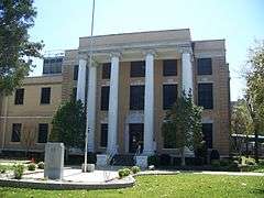
The Bay County Courthouse in March 2008 | |||
| |||
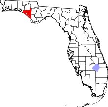 Location in the U.S. state of Florida | |||
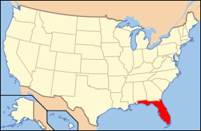 Florida's location in the U.S. | |||
| Founded | April 24, 1913 | ||
| Named for | St. Andrews Bay | ||
| Seat | Panama City | ||
| Largest city | Panama City | ||
| Area | |||
| • Total | 1,033 sq mi (2,675 km2) | ||
| • Land | 758 sq mi (1,963 km2) | ||
| • Water | 275 sq mi (712 km2), 26.6% | ||
| Population (est.) | |||
| • (2015) | 181,635 | ||
| • Density | 223/sq mi (86/km²) | ||
| Congressional district | 2nd | ||
| Time zone | Central: UTC-6/-5 | ||
| Website |
www | ||

Bay County is a county in the U.S. state of Florida. As of the 2010 census, the population was 168,852.[1] Its county seat is Panama City.[2]
Bay County is included in the Panama City, Florida Metropolitan Statistical Area. The county is best known for its white sand beaches and emerald green water, where large pods of dolphins swim year-round. These beaches attract hundreds of thousands of visitors from all over the world each year.
History
On February 12, 1913, representatives from five towns on St. Andrews Bay met in Panama City to select a name for a proposed new county. The name Bay was selected because it was satisfactory to the majority of the citizens and was descriptive of the territory that would be included. On July 1, 1913, Bay County was created by the Legislature from portions of Washington, Calhoun and Walton counties.
It was the site of Gideon v. Wainwright, which gave all persons accused of a crime the right to an attorney.
Geography
According to the U.S. Census Bureau, the county has a total area of 1,033 square miles (2,680 km2), of which 758 square miles (1,960 km2) is land and 275 square miles (710 km2) (26.6%) is water.[3]
Adjacent counties
- Washington County, Florida - north
- Jackson County, Florida - northeast
- Calhoun County, Florida - east
- Gulf County, Florida - southeast
- Walton County, Florida - west
National protected area
- Apalachicola National Forest (part)
Demographics
| Historical population | |||
|---|---|---|---|
| Census | Pop. | %± | |
| 1920 | 11,407 | — | |
| 1930 | 12,091 | 6.0% | |
| 1940 | 20,686 | 71.1% | |
| 1950 | 42,689 | 106.4% | |
| 1960 | 67,131 | 57.3% | |
| 1970 | 75,283 | 12.1% | |
| 1980 | 97,740 | 29.8% | |
| 1990 | 126,994 | 29.9% | |
| 2000 | 148,217 | 16.7% | |
| 2010 | 168,852 | 13.9% | |
| Est. 2015 | 181,635 | [4] | 7.6% |
| U.S. Decennial Census[5] 1790-1960[6] 1900-1990[7] 1990-2000[8] 2010-2015[1] | |||
As of the census[9] of 2000, there were 148,217 people, 59,597 households, and 40,466 families residing in the county. The population density was 194 people per square mile (75/km²). There were 78,435 housing units at an average density of 103 per square mile (40/km²). The racial makeup of the county was 84.17% White, 10.64% Black or African American, 0.78% Native American, 1.73% Asian, 0.08% Pacific Islander, 0.66% from other races, and 1.94% from two or more races. 2.42% of the population were Hispanic or Latino of any race.
There were 59,597 households out of which 30.60% had children under the age of 18 living with them, 52.00% were married couples living together, 12.00% had a female householder with no husband present, and 32.10% were non-families. 26.00% of all households were made up of individuals and 8.80% had someone living alone who was 65 years of age or older. The average household size was 2.43 and the average family size was 2.92.
In the county the population was spread out with 24.00% under the age of 18, 8.70% from 18 to 24, 30.20% from 25 to 44, 23.70% from 45 to 64, and 13.40% who were 65 years of age or older. The median age was 37 years. For every 100 females there were 98.10 males. For every 100 females age 18 and over, there were 95.80 males.
The median income for a household in the county was $36,092, and the median income for a family was $42,729. Males had a median income of $30,116 versus $21,676 for females. The per capita income for the county was $18,700. About 9.80% of families and 13.00% of the population were below the poverty line, including 18.30% of those under age 18 and 11.00% of those age 65 or over.
Government
Elected Officials
| Bay County Government | ||
|---|---|---|
| Sheriff | Tommy Ford [10] | Republican |
| Tax Collector | Peggy Brannon | Democrat |
| Clerk of the Court | Bill Kinsaul | Republican |
| Supervisor of Elections | Mark Anderson | Republican |
| Superintendent of Schools | William Husfelt, III | Republican |
| Property Appraiser | Dan Sowell | Republican |
Board of Commissioners
5 members, elected from districts (zero Democrats, four Republicans)[11]
| District | Commissioner | Party | Positions |
|---|---|---|---|
| 1 | Mike Nelson | Republican | Chair of the County Commission |
| 2 | George Gainer | Republican | |
| 3 | Bill Dozier | Republican | Vice Chair of the County Commission |
| 4 | Guy Tunnell | Republican | |
| 5 | Vacant | Vacant |
Politics
Voter Registration
According to the Secretary of State's office, Republicans are a majority of the registered voters in Bay County.
| Bay County Voter Registration & Party Enrollment as of September 30, 2015[12] | |||||
|---|---|---|---|---|---|
| Political Party | Total Voters | Percentage | |||
| Republican | 53,434 | 50.31% | |||
| Democratic | 30,253 | 28.48% | |||
| Independent | 20,012 | 18.84% | |||
| Third Parties | 2,511 | 2.36% | |||
| Total | 106,210 | 100% | |||
Statewide Elections
| Year | Republican | Democratic | Third Parties |
|---|---|---|---|
| 2012 | 71.01% 56,876 | 27.53% 22,051 | 1.46% 1,174 |
| 2008 | 69.66% 56,683 | 29.07% 23,653 | 1.27% 1,030 |
| 2004 | 71.18% 53,404 | 28.08% 21,068 | 0.74% 552 |
| 2000 | 65.70% 38,682 | 32.06% 18,873 | 2.24% 1,321 |
| 1996 | 54.86% 28,290 | 33.01% 17,020 | 12.13% 6,256 |
| 1992 | 50.00% 22,820 | 28.11% 12,830 | 21.89% 9,991 |
| Year | Republican | Democratic | Third Parties |
|---|---|---|---|
| 2014 | 71.79% 40,956 | 22.77% 12,990 | 5.44% 3,104 |
| 2010 | 66.39% 36,512 | 28.53% 15,689 | 5.08% 2,796 |
| 2006 | 65.26% 31,382 | 30.78% 14,802 | 3.96% 1,907 |
| 2002 | 70.02% 34,107 | 29.27% 14,258 | 0.71% 344 |
| 1998 | 69.01% 26,759 | 30.99% 12,017 | 0.00% 2 |
| 1994 | 56.87% 23,498 | 43.12% 17,816 | 0.01% 2 |
Education
Bay District Schools operates public schools serving all portions of the county except for Mexico Beach, which is served by Gulf County Schools.[13][14][15]
Public Transportation
Airports
Northwest Florida Beaches International Airport
Public Surface Transportation
The county operates the Baytown Trolley, which runs several routes in and around Panama City.[16]
Library
Bay County is part of the Northwest Regional Library System (NWRLS), which serves Gulf and Liberty Counties as well.
Locations:
- Bay County Public Library
- Panama City Beach Public Library
- Parker Public Library
- Springfield Public Library
- Gulf County Public Library
- Charles Whitehead Public Library
- Harrell Memorial Library of Liberty County
- Jimmy Weaver Memorial Library
Communities
.jpg)
Cities
Census-designated places
Unincorporated communities
See also
References
- 1 2 "State & County QuickFacts". United States Census Bureau. Retrieved June 12, 2014.
- ↑ "Find a County". National Association of Counties. Archived from the original on 2012-07-12. Retrieved 2011-06-07.
- ↑ "US Gazetteer files: 2010, 2000, and 1990". United States Census Bureau. 2011-02-12. Retrieved 2011-04-23.
- ↑ "County Totals Dataset: Population, Population Change and Estimated Components of Population Change: April 1, 2010 to July 1, 2015". Retrieved July 2, 2016.
- ↑ "U.S. Decennial Census". United States Census Bureau. Archived from the original on May 11, 2015. Retrieved June 12, 2014.
- ↑ "Historical Census Browser". University of Virginia Library. Retrieved June 12, 2014.
- ↑ "Population of Counties by Decennial Census: 1900 to 1990". United States Census Bureau. Retrieved June 12, 2014.
- ↑ "Census 2000 PHC-T-4. Ranking Tables for Counties: 1990 and 2000" (PDF). United States Census Bureau. Retrieved June 12, 2014.
- ↑ "American FactFinder". United States Census Bureau. Archived from the original on 2013-09-11. Retrieved 2011-05-14.
- ↑ http://www.mypanhandle.com/news/new-era-for-bay-county-tommy-ford-sworn-in-as-sheriff
- ↑ http://www.baycountyfl.gov/Commissioners/
- ↑ http://dos.myflorida.com/elections/data-statistics/voter-registration-statistics/voter-registration-monthly-reports/voter-registration-current-by-county/
- ↑ "Bay District Schools High School Attendance Zones." Bay District Schools. Accessed October 10, 2008.
- ↑ "Bay District Schools Middle School Attendance Zones." Bay District Schools. Accessed October 10, 2008.
- ↑ "Bay District Schools Elementary School Attendance Zones." Bay District Schools. Accessed October 10, 2008.
- ↑ "Archived copy". Archived from the original on 2013-12-03. Retrieved 2013-11-26.
External links
| Wikimedia Commons has media related to Bay County, Florida. |
Government links/Constitutional offices
- Bay County Board of County Commissioners
- Bay County Supervisor of Elections
- Bay County Property Appraiser
- Bay County Sheriff's Office
- Bay County Tax Collector
Special districts
- Bay District Schools
- Beach Mosquito Control District
- Northwest Florida Water Management District
- Panama City-Bay County Airport and Industrial District
Judicial branch
- Bay County Clerk of Courts
- Circuit and County Court for the 14th Judicial Circuit of Florida serving Bay, Calhoun, Gulf, Holmes, Jackson and Washington counties
Tourism links
News media
 |
Washington County | Jackson County | | |
| Walton County | |
Calhoun County | ||
| ||||
| | ||||
| Gulf of Mexico | Gulf County |
Municipalities and communities of Bay County, Florida, United States | ||
|---|---|---|
| Cities | | |
| CDPs | ||
| Unincorporated communities | ||
Coordinates: 30°14′N 85°38′W / 30.24°N 85.63°W