Pelham Gardens, Bronx
| Pelham Gardens | |
|---|---|
| Neighborhood of The Bronx | |
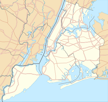 Pelham Gardens  Pelham Gardens  Pelham Gardens Location in New York City | |
| Coordinates: 40°51′40″N 73°50′41″W / 40.861147°N 73.844692°WCoordinates: 40°51′40″N 73°50′41″W / 40.861147°N 73.844692°W | |
| Country |
|
| State |
|
| City |
|
| Borough |
|
| Area[1] | |
| • Total | 1.96 km2 (0.757 sq mi) |
| Population (2011)[1] | |
| • Total | 15,388 |
| • Density | 7,800/km2 (20,000/sq mi) |
| Economics | |
| • Median income | $68,249 |
| ZIP codes | 10469 |
| Area code | 718, 347, 646 |
Pelham Gardens is a middle-class neighborhood geographically located in the Northeast section of New York City in the United States. Its boundaries, starting from the north and moving clockwise are: East Gun Hill Road to the north and east, Pelham Parkway to the south, and Laconia Avenue to the west. Eastchester Road is the primary thoroughfare through Pelham Gardens. The local subway is the 5 line; operating alongside Esplanade. ZIP codes include 10469. The area is patrolled by the New York Police Department's 49th Precinct located at 2121 Eastchester Road in Morris Park.
History
The area was originally home to the Siwanoy, a Native American tribe affiliated with the Algonquian peoples. The name Pelham Gardens derives from Thomas Pell, who purchased the land from the Siwanoy on June 27, 1654 at Treaty Oak, located next to Shore road in what is now Pelham Bay Park. The town of Westchester was established at this time at what is now Westchester Square; the entire area was part of Westchester County, New York until the city of New York, New York purchased the land at the turn of the 20th century. The oldest house in the area is what was once a farmhouse, located at the corner of Woodhull Avenue and Fielding Street.
The neighborhood is socioeconomically diverse, with a considerable working class population as well as many upper middle class professionals, particularly in the eastern area of the community. The proximity to major hospitals and a high concentration of private medical facilities has drawn many health care professionals into the areas, as well as police officers, lawyers, and small business owners, particularly in the fields of construction and food services.[2]
Land use and terrain
Pelham Gardens is dominated by single family homes with some small apartment buildings and 2-3 family homes. Many private homes have basement studio apartments but are classified as one family. The total land area is roughly two square miles. The area its largely flat but contains a significant valley between Eastchester Road and Laconia Avenue, with the most significant low point on Seymour Avenue. This dip was likely caused thousands of years ago by a glacier.
Demographics
Based on data from the 2010 United States Census, the population of the combined Allerton-Pelham Gardens neighborhood was 28,903, an increase of 393 (1.4%) from the 28,510 counted in 2000. Covering an area of 726.98 acres (294.20 ha), the neighborhood had a population density of 39.8 inhabitants per acre (25,500/sq mi; 9,800/km2).[3]
The racial makeup of the Allerton-Pelham Gardens neighborhood was 25.3% (7,316) White, 32.5% (9,391) African American, 0.2% (55) Native American, 7.9% (2,282) Asian, 0.0% (12) Pacific Islander, 0.9% (252) from other races, and 1.4% (412) from two or more races. Hispanic or Latino of any race were 31.8% (9,183) of the population.[4]
Demographically, the neighborhood has historically been home to a large Italian-American population as well as a sizable Jewish population, which has dramatically decreased since the 1970s. Smaller numbers of Irish-Americans and German-Americans have also made this largely Catholic community home since significant development began in the 1920s, with a construction boom in the 1950s. Large numbers of Puerto Rican families have moved into the area since the 1980s, with smaller but significant numbers of Filipino-Americans, African-Americans, Dominican-Americans, Albanian-Americans, Korean Americans, and Vietnamese Americans.[5][6]
Transportation
- Bx12 Local and Select Bus Service: to Bay Plaza Shopping Center and Inwood – 207th Street (A train) (via Fordham Road and Pelham Parkway)
- Bx26: to Co-op City and Lehman College (via Bedford Park Blvd and Allerton Av)
- Bx28/Bx38: to Co-op City and Fordham (via East Gun Hill Road)
- Bx31: to Woodlawn and Westchester Square station (via Eastchester Road)
- BxM10: to East Side, Manhattan (formerly part of New York Bus Service)
- Pelham Parkway (5 train)
- Gun Hill Road (5 train)
Politics
The area is represented by:
- James Vacca - City Council
- Mark Gjonaj - 80th Assembly District
- Michael Benedetto - 82nd Assembly District
- Jeffrey David Klein - 34th Senate District
- Joe Crowley - 14th District, US Congress [7]
- Kirsten Gillibrand - US Senate
- Charles Schumer - US Senate
References
- 1 2 "Pelham Gardens neighborhood in New York". Retrieved 1 January 2016.
- ↑ Wilson, Claire. "AutosIf You're Thinking of Living In/Pelham Gardens, the Bronx; Attractive, Affordable and Unheralded", The New York Times, December 8, 2002. Accessed August 14, 2016. "Interns and residents from the medical facilities rent apartments in the two- or three-family houses in Pelham Gardens and are part of a professional mix that includes small-business owners and merchants from Arthur Avenue as well as judges, nurses, professors and up-and-coming chefs."
- ↑ Table PL-P5 NTA: Total Population and Persons Per Acre - New York City Neighborhood Tabulation Areas*, 2010, Population Division - New York City Department of City Planning, February 2012. Accessed June 16, 2016.
- ↑ Table PL-P3A NTA: Total Population by Mutually Exclusive Race and Hispanic Origin - New York City Neighborhood Tabulation Areas*, 2010, Population Division - New York City Department of City Planning, March 29, 2011. Accessed June 14, 2016.
- ↑ Bronx Community District 11
- ↑ Plambeck, Joseph. "The Merits of Safe and Sound". The New York Times. Retrieved 1 January 2016.
- ↑ "Joseph Crowley, U.S. Representative for New York's 14th Congressional District - GovTrack.us". GovTrack.us. Retrieved 1 June 2015.