Longwood, Bronx
| Longwood | |
|---|---|
| Neighborhood of The Bronx | |
|
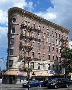
Southern Boulevard in Longwood | |
 Longwood  Longwood  Longwood Location in New York City | |
| Coordinates: 40°49′02″N 73°53′57″W / 40.817323°N 73.899303°WCoordinates: 40°49′02″N 73°53′57″W / 40.817323°N 73.899303°W | |
| Country |
|
| State |
|
| City |
|
| Borough |
|
| Area[1] | |
| • Total | 1.27 km2 (0.489 sq mi) |
| Population (2010)[2] | |
| • Total | 26,196 |
| • Density | 21,000/km2 (54,000/sq mi) |
| Economics | |
| • Median income | $25,461 |
| Ethnicity[3] | |
| • Hispanic and Latino Americans | 74.6% |
| • African-American | 22.4% |
| • White | 1.5% |
| • Asian | 0.5% |
| • Others | 1.1% |
| ZIP codes | 10455, 10459 |
| Area code | 718, 347, 646 |
Longwood is an urban, mixed use, primarily residential neighborhood geographically located in the southwest Bronx, New York City. The neighborhood is part of Bronx Community Board 2. Its boundaries, starting from the north and moving clockwise are East 167th Street to the north, the Bronx River and the Bruckner Expressway to east, East 149th Street to the south, and Prospect Avenue to the west. Southern Boulevard is the primary thoroughfare through Longwood. The local subway is the 6 <6> trains, operating along Southern Blvd. ZIP codes include 10455 and 10459. The neighborhood is served by the New York City Police Department's 41st Precinct.[4] NYCHA property in the area is patrolled by P.S.A. 7 at 737 Melrose Avenue in the Melrose section of the Bronx.
History

The Bronx initially began to become urban with the construction of a street-car network. Eventually, the expansion of the elevated and subterranean rapid transit lines from Manhattan rapidly accelerated development. Solid rows of 5 and 6 story, walk-up and larger elevator, apartment buildings were built to the sidewalk and dominated the landscape of Upper Manhattan, the West Bronx and in walking proximity of the elevated lines in the East Bronx. Commercial corridors quickly developed in close proximity to rapid transit stations and primary thoroughfares. Early in this construction boom, Longwood was one of the most dense and developed Bronx neighborhoods. For much the first half of the 20th Century, the borough of the Bronx was home to a predominantly middle class, White, European descent, Jewish population. Still, there was great diversity. Immigrants of varying socioeconomic status from a number of countries, but mostly European.[5]
Beginning in the 1950s, the older, more developed parts of the Bronx experienced a socioeconomic shift due to a number of factors. The construction of the Cross Bronx Expressway displaced thousands and physically divided communities, Co-op City in the northeast Bronx offered modern amenities and spacious apartments, and suburban communities outside New York City became more appealing with their auto-centric lifestyle. As people with financial means began to leave, poverty stricken often replaced them. White flight and abandonment only accelerated over time. By the late 1970s, many buildings in the greater South Bronx had been burnt out in an epidemic wave of arson. Scammers realized they could manipulate the system and collect insurance money after more lucrative tenants had fled. The area was severely run down as the community became increasingly disfranchised. At this time, crime reached such a level that the 41st Precinct Station House at 1086 Simpson Street became known by the police as "Fort Apache", as was later immortalized in a 1981 movie named for it.[6][7]
The wave of arson eventually ended with the help of community groups such as Banana Kelly CIA, Inc. and SEBCO (South East Bronx Community Organization), who worked to bring recognition and protect the remaining apartment buildings in the greater South Bronx.[8][9] What was left was a wasteland of abandoned buildings, vacant lots, filthy streets and a severe lack of even basic commercial amenities. During this period of time, the neighborhood was dealt another blow as violent crime hit historic highs during the crack epidemic. The police seemed to be fighting a losing battle as thousands of young men in New York City were regularly being killed on the streets over drug turf. The greater South Bronx was one of the hardest hit areas, with a largely poor population which lacked local jobs, many began to turn to the lucrative drug trade.[10]
Some of the first federal funding in decades for new investment began in 1986 under the Ed Koch administration. In blighted neighborhoods across the city, various housing experiments were attempted. The NYCHA was one of the first agencies to create and renovate residential units in Longwood, the city soon followed up with independent, locally driven developments. This construction resulted in escalating reinvestment in these communities Continuing into the mid-1990s, local and federal governments invested over $550 million in new subsidized residential housing and the expansion of businesses and commerce. With the building of the South Bronx headquarters of P.A.L.; the relocation of the 41st Precinct of the NYPD from Simpson Street to Longwood Avenue; the Banana Kelly High School; and several small and large businesses (such as Rite Aid and McDonald's). This investment has only increased exponentially since that time. A vast number of new housing and commercial units have been constructed on formally vacant lots, with more planned. A community once dominated by blight and disinvestment, is now towered over by modern apartment buildings, renovated pre-wars, and rows of attached row houses. Social problems persist due to a significant percentage of the population living in poverty. Crime for instance has declined versus historic highs in the 1990s, but remain well above average in New York City. However, the neighborhood improved and has come a long way.[11]
Demographics
Based on data from the 2010 United States Census, the population of Longwood was 26,196, an increase of 3,114 (13.5%) from the 23,082 counted in 2000. Covering an area of 246.55 acres (99.78 ha), the neighborhood had a population density of 106.3 inhabitants per acre (68,000/sq mi; 26,300/km2).[2]
The racial makeup of the neighborhood was 1.5% (382) White, 22.4% (5,866) African American, 0.1% (32) Native American, 0.5% (135) Asian, 0.0% (9) Pacific Islander, 0.3% (78) from other races, and 0.6% (163) from two or more races. Hispanic or Latino of any race were 74.6% (19,531) of the population.[12]
The neighborhood predominantly consists of Latin Americans (Longwood has one of the highest concentrations of Puerto Ricans in New York City) but includes a small yet diverse mix of races, ethnic groups, religious affiliations, sexual orientations, and national origins. Like most neighborhoods in New York City, the vast majority of households are renter occupied. Almost half of the population lives below the federal poverty line and receives public assistance (AFDC, Home Relief, Supplemental Security Income, and Medicaid). This community was once part of New York's 16th congressional district, the poorest such district in the United States. After redistricting, it is now part of New York's 15th congressional district and no longer the poorest district in the United States. There is significant income diversity on a block by block basis.[1][13]
Land use and terrain
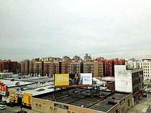
Longwood is dominated by pre-war, 5- and 6-story apartment buildings. Starting in the 1990s, a construction boom has resulted in a number of modern apartment buildings and row houses. Much of the original housing stock was structurally damaged by arson and eventually razed by the city between mid and late 1900s.[11]
The total land area is roughly 0.5 square miles (1.3 km2). The terrain is somewhat hilly.
Southern Boulevard Business Improvement District
Southern Boulevard is a long-standing, mixed use, primarily commercial district. The Southern Blvd. Business Improvement District (Formed in 2008)[14] sits between the two points of closest proximity for the IRT Pelham and White Plains Road line.[15] Other primary thoroughfares contain limited but necessary amenities like supermarkets, pharmacies, barbershops, hair salons, fast food, bodegas, and cheap shops.
The Crossings
'The Crossings' is a two-level 40,000-square-foot (3,700 m2) mall being planned at the intersection of Hunts Point Avenue and Bruckner Boulevard which is slated to open sometime in 2016. It is notable for featuring the borough's second Red Lobster restaurant, the first being in Co-op City. Other notable tenants include Bank of America, Dunkin' Donuts and Deals.[16] Initially, the project included a residential component, but was quickly scrapped, much to the dismay of the community.[17][18][19]
Longwood Historic District
The landmarked Longwood Historic District is located south of Longwood Avenue along Beck, Kelly, Dawson Streets and Hewitt Place. The district largely consists of semi-detached row houses, most of which were designed by one architect, Warren C. Dickerson.[20][21]
Low income public housing projects
There are four NYCHA developments located in Longwood.[22]
- West Farms Square Rehab; four rehabilitated tenement buildings, 6-stories tall.
- East 165th Street-Bryant Avenue; five buildings, 3-stories tall.
- Longfellow Avenue Rehab; two, 5-story rehabilitated tenement buildings.
- Stebbins Avenue-Hewitt Place; two, 3-story buildings.
Media
In 2006, an online news outlet The Hunts Point Express began reporting on Hunts Point and Longwood. It is written by students at Hunter College, edited by journalism professor Bernard L. Stein, and also appears in a print edition that is available for free at community centers, clinics, and stores throughout the neighborhood.
Education

Library
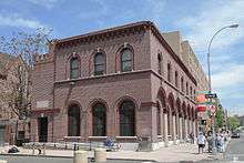
The Hunts Point Branch of the New York Public Library was completed in 1929 as the last Carnegie library in the system. The building was designed by Carrère and Hastings, the architects of the main library in the Italian Renaissance style, with seven brick archways across the facade.[23] In April 2009, the New York Landmarks Preservation Commission designated the building a New York City Landmark, citing the design, history, and cultural significance.[24]
Schools
Public:
- PS 333: The Museum School (East 163rd Street and Rev. James A. Polite Avenue)
- PS 335: The Academy of the Arts (East 163rd Street and Rev. James A. Polite Avenue)
- PS 62: Inocencio Casanova (Leggett Avenue and Fox Street)
- PS 130: Abram Stevens Hewitt (East 156th Street and Prospect Avenue)
- PS 150: Charles James Fox (East 167th Street and Fox Street)
- MS 302: Luisa Dessus Cruz (Kelly Street and Avenue St. John)
- Bronx Regional High School (East 165th Street and Rev. James A. Polite Avenue)
- South Bronx Classical Charter School (Westchester Avenue and Fox Street)
- Bronx Studio School for Writers and Artists
- Banana Kelly High School
Parochial:
- St. Athanasius School[25]
Transportation
- Bx4/Bx4A: to Westchester Square – East Tremont Avenue (6 <6>) (via Westchester Avenue)
- Bx5: to Pelham Bay Park (via Story Avenue)
- Bx6: to Hunts Point or Riverside Drive-158th Street, Manhattan (via 161st and 163rd Streets)
- Bx11: to George Washington Bridge Bus Terminal (via 170th St and Claremont Pkwy)
- Bx17: to Fordham Plaza or Port Morris (via Prospect and Crotona Avenues)
- Bx19: to New York Botanical Gardens or Riverbank State Park (via 149th Street and Southern Boulevard)
- Bx27: to Clason Point (via Rosedale Avenue)
- Bx35: to George Washington Bridge Bus Terminal (via 167th Street)
- Bx46: to Prospect Avenue (IRT White Plains Road Line) (2 5) or Hunts Point (via Longwood and Tiffany Streets)
- Whitlock Avenue (IRT Pelham Line) (6)
- Simpson Street (IRT White Plains Road Line) (2 5)
- Intervale Avenue (IRT White Plains Road Line) (2 5)
- Hunts Point Avenue (IRT Pelham Line) (6 <6>)
- Prospect Avenue (IRT White Plains Road Line) (2 5)
- Longwood Avenue (IRT Pelham Line) (6)
- East 149th Street (IRT Pelham Line) (6)
Notable natives
- Colin Powell lived on both Kelly Street and Fox Street, and attended Morris High School.[26]
References
- 1 2 "Longwood neighborhood in New York". Retrieved August 3, 2015.
- 1 2 Table PL-P5 NTA: Total Population and Persons Per Acre - New York City Neighborhood Tabulation Areas*, 2010, Population Division - New York City Department of City Planning, February 2012. Accessed June 16, 2016.
- ↑ "Center for Urban Research". Retrieved August 3, 2015.
- ↑ 41st Precinct, New York City Police Department.
- ↑ "The Bronx County Historical Society". Retrieved 22 September 2015.
- ↑ Fisher, Ian (1993-06-23). "Pulling Out of Fort Apache, the Bronx; New 41st Precinct Station House Leaves Behind Symbol of Community's Past Troubles". The New York Times. Retrieved 2007-12-26.
He stretched his memory back 25 years to his days as a rookie patrolman in the 41st Precinct, whose station house was known from here to Hollywood as Fort Apache, a solitary outpost in a neighborhood of death and decay and gangs with grandiosely macabre names.
- ↑ Slattery, Denis. "South Bronx celebrates 100 years of former police precinct, known as Fort Apache". NY Daily News. Retrieved 23 October 2015.
- ↑ Banana Kelly CIA, Inc.
- ↑ SEBCO
- ↑ Kifner, John. "Soldiers in the Crack War: Fighting Street by Street". The New York Times. Retrieved 25 November 2015.
- 1 2 "A Slow Renaissance for a Struggling Neighborhood". The New York Times. Retrieved 1 October 2015.
- ↑ Table PL-P3A NTA: Total Population by Mutually Exclusive Race and Hispanic Origin - New York City Neighborhood Tabulation Areas*, 2010, Population Division - New York City Department of City Planning, March 29, 2011. Accessed June 14, 2016.
- ↑ Bronx Community District 2
- ↑ "Stores BID to improve shopping". Hunts Point Express. Retrieved 23 October 2015.
- ↑ Southern Blvd BID
- ↑ Trangle, Sarina. "Selling the Mall Boom in the Bronx". City & State. Retrieved 25 November 2015.
- ↑ Cuevas, Luis. "Red Lobster coming to Hunts Point". Hunts Point Express. Retrieved 25 November 2015.
- ↑ Williams, Jaime. "Hunts Point gets ready for Red Lobster opening". Retrieved 25 November 2015.
- ↑ Slattery, Denis. "A new mall in the South Bronx will feature a huge Red Lobster and a McDonalds -- but no housing". NY Daily News. Retrieved 25 November 2015.
- ↑ Longwood Historic District
- ↑ Larry E. Gobrecht (June 1981). "National Register of Historic Places Registration: Longwood Historic District". New York State Office of Parks, Recreation and Historic Preservation. Retrieved 2011-01-12.
- ↑ NYCHA
- ↑ "The New York Public Library Branch Information". Retrieved 2015-08-03.
- ↑ "Press Release" (PDF). Retrieved 2009-04-14.
- ↑ "St. Athanasius School Website".
- ↑ "Fox Street co-op draws middle income residents". Hunts Point Express. Retrieved 10 October 2015.
External links
| Wikimedia Commons has media related to Longwood, Bronx. |