Pennsylvania Route 66
| |||||||
|---|---|---|---|---|---|---|---|
|
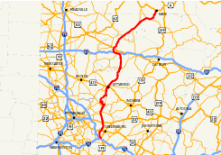
Major highways in Western Pennsylvania with PA 66 in red. | |||||||
| Route information | |||||||
| Maintained by PennDOT, PTC | |||||||
| Length: | 139 mi[1] (224 km) | ||||||
| Existed: | 1927 – present | ||||||
| Major junctions | |||||||
| South end: |
| ||||||
|
| |||||||
| North end: |
| ||||||
| Location | |||||||
| Counties: | Westmoreland, Armstrong, Clarion, Forest, Elk, McKean | ||||||
| Highway system | |||||||
| |||||||


Pennsylvania Route 66 (PA 66) is a 139 miles (224 km) long state highway in Western Pennsylvania. Its northern terminus is at U.S. Route 6 in Kane. Its southern terminus is at US 119 (just east of Interstate 70) near New Stanton. West of Greensburg, PA 66 becomes the tolled Amos K. Hutchinson Bypass, a part of the Pennsylvania Turnpike System. The Bypass runs between U.S. Route 119 and U.S. Route 22.
Route description
Amos K. Hutchinson Bypass
PA 66 begins in New Stanton at a cloverleaf interchange with US 119, immediately east of connections to Interstate 70 and Interstate 76/Pennsylvania Turnpike. Exit 1 is for Arona Road, where no tolls are collected. Exit 4 is the first toll exit. Exit 4 is located in Hempfield Township and PA 66 interchanges with Pennsylvania Route 136 at exit 4. 1 mile (1.6 km) north of PA 136, PA 66 reaches the Hempfield Toll Plaza. Southeast of Jeannette, PA 66 interchanges with U.S. Route 30 at exit 6. Exit 8 is located 1 mile (1.6 km) east of Jeannette and PA 66 interchanges with Pennsylvania Route 130. At exit 9, PA 66 interchanges with Pennsylvania Route 66 Business the former routing of PA 66. At exit 12, PA 66 interchanges with the northern terminus of PA 66 Business. At exit 14, PA 66 meets U.S. Route 22 at a single-point urban interchange. North of US 22, PA 66 continues north at-grade.
Westmoreland County
North of the Amos K. Hutchinson Bypass, PA 66 enters Salem Township as Sheridan Road. In Delmont, PA 66 is called Sheridan Road. In Washington Township, PA 66 passes west of Beaver Run Reservoir. In the village of Mamont, PA 66 intersects Pennsylvania Route 286. In the village of Poke Run north of PA 286, PA 66 intersects the eastern terminus of Pennsylvania Route 366. Then PA 66 intersects Pennsylvania Route 380, PA 380 west heads for downtown Pittsburgh. South of Oklahoma, PA 66 intersects the southern terminus of Pennsylvania Route 356. In the village of Paulton, PA 66 intersects the southern terminus of Pennsylvania Route 66 Alternate. PA 66 Alternate goes into Vandergrift and PA 66 goes into Apollo. In Oklahoma, PA 66 meets the northern terminus of Pennsylvania Route 819. In downtown Oklahoma, PA 66 turns to the east and crosses the Kiskiminetas River.
Armstrong County
After crossing the Kiskiminetas River, PA 66 has entered Armstrong County and begins a concurrency with Pennsylvania Route 56 in Apollo. As they began their concurrency, PA 56/PA 66 were called Warren Avenue in Apollo. As PA 56/PA 66 enter the boro of North Apollo they are paralleling the Kiskiminetas River. In the village of North Vandergrift, the concurrency between PA 56 and PA 66 ends when PA 66 intersects PA 66 Alternate and PA 56 and PA 66 ALT begin their own concurrency into Vandergrift. As PA 66 continues to parallel the Kiskiminetas River, it is called Lincoln Avenue. While paralleing the Kiskiminetas River, PA 66 has snake like curves. In Leechburg, PA 66 becomes Market Street, 3rd Street, and Pershing Avenue. As PA 66 exits Leechburg it is not paralleling the Kiskiminetas River. In Bethel Township, PA 66 meets the northern terminus of PA 66 Alternate. In Ford City, PA 66 becomes Main Street and intersects the northern terminus of Pennsylvania Route 128 at an "Y" intersection. Southeast of Kittanning, PA 66 begins a concurrency with U.S. Route 422 and Pennsylvania Route 28 at an interchange. At the next exit US 422 leaves the concurrency and PA 28/PA 66 continue north at-grade. In Rayburn Township, PA 28/PA 66 intersect the western terminus of Pennsylvania Route 85. PA 28/PA 66 continue towards the northeast without intersecting a route for more than 17 miles (27 km). In South Bethlehem, PA 28/PA 66 become Broad Street and meet the northern terminus of Pennsylvania Route 839. The route then crosses the Redbank Creek into Clarion County after spending 43 miles in Armstrong County.
Clarion County
After crossing the Redbank Creek, PA 28/PA 66 have entered Clarion County. In New Bethlehem, The concurrency between PA 28 and PA 66 ends when PA 66 leaves PA 28. North of PA 28, PA 66 becomes Wood Street and intersects the eastern terminus of Pennsylvania Route 861. In Clarion Township, PA 66 begins a concurrency with Interstate 80 at exit 64. Then I-80/PA 66 meet Pennsylvania Route 68 at exit 62. After crossing the Clarion River, PA 66 leaves I-80 at exit 60 (trumpet interchange). PA 66 continues north at-grade. In Paint Township, PA 66 intersects U.S. Route 322 as Paint Boulevard. PA 66 continues towards the north paralleling rail road tracks. In Farmington Township, PA 66 intersects Pennsylvania Route 36.
Forest, Elk, and McKean Counties
As PA 66 enters Forest County, PA 66 intersects the northern terminus of Pennsylvania Route 899. In Jenks Township, PA 66 enters Allegheny National Forest. As PA 66 enters Elk County, PA 66 has a 2 miles (3 km) concurrency with Pennsylvania Route 948. Northeast of PA 948, PA 66 becomes Kane-Russell City Road. PA 66 enters McKean County as Fraley Street. In Kane, PA 66 ends at a "T" intersection with U.S. Route 6.[2][3]
Tolls
The Amos K. Hutchinson Bypass portion of the route has tolls. Tolls are collected once during travel on the road, either at the mainline toll barrier, or at the exit or entrance point, depending on the possibility of reaching the mainline toll barrier during travel. No toll is charged for travel between exits 0 and 1 or between exits 12 and 14. Tolls are paid either by cash or E-ZPass. At the mainline toll barrier, a manned full service lane exists. For most exit ramp tolls, exact change is required; however some automatic toll collection machines accept paper money and give change. All toll collecting machines give receipts.
As of 2016, the mainline toll barrier between exits 4 and 6 costs passenger vehicles $2.30 using cash and $1.55 using E-ZPass. At the northbound exit and southbound entrance at exit 4 and the southbound exit and northbound entrance at exit 6, passenger vehicles are charged $1.80 using cash and $1.16 using E-ZPass. The southbound exit and northbound entrance at exits 8 and 9 costs passenger vehicles $1.35 using cash and $0.76 using E-ZPass.[4]
Major intersections
| County | Location | mi[5] | km | Old exit [6] | New exit [6] | Destinations | Notes | |
|---|---|---|---|---|---|---|---|---|
| Westmoreland | New Stanton | 0.0 | 0.0 | 1 | 0 | Split into 0A and 0B, I-70 / I-76 / Penna Turnpike exit 75 (New Stanton) | ||
| 1.0 | 1.6 | 2 | 1 | Arona Road | ||||
| Southern terminus of toll collection | ||||||||
| Greensburg | 4.3 | 6.9 | 3 | 4 | Toll for northbound exit and southbound entrance | |||
| Haydentown Mainline Toll Barrier | ||||||||
| 6.2 | 10.0 | 4 | 6 | Toll for southbound exit and northbound entrance | ||||
| 7.7 | 12.4 | 5 | 8 | Toll for southbound exit and northbound entrance | ||||
| 9.3 | 15.0 | 6 | 9 | Toll for southbound exit and northbound entrance | ||||
| Delmont | Northern terminus of toll collection | |||||||
| 12.5 | 20.1 | 7 | 12 | Former routing of PA 66 | ||||
| 13.5 | 21.7 | 8 | 14 | |||||
| Northern terminus of Toll PA 66, PA 66 continues north at-grade | ||||||||
| Washington Township | 19.2 | 30.9 | ||||||
| 20.0 | 32.2 | Eastern terminus of PA 366 | ||||||
| 23.0 | 37.0 | |||||||
| 24.7 | 39.8 | Southern terminus of PA 356 | ||||||
| 26.3 | 42.3 | Southern terminus of Alternate PA 66 | ||||||
| 26.6 | 42.8 | Northern terminus of PA 819 | ||||||
| Armstrong | Apollo | 27.3 | 43.9 | South end of PA 56 overlap | ||||
| Parks Township | 29.9 | 48.1 | North end of PA 56 overlap | |||||
| Bethel Township | 43.5 | 70.0 | Northern terminus of Alternate PA 66 | |||||
| Ford City | 49.1 | 79.0 | Northern terminus of PA 128 | |||||
| Manor Township | 50.3 | 81.0 | Interchange, south end of US 422/PA 28 overlap | |||||
| 52.3 | 84.2 | Interchange, north end of US 422 overlap | ||||||
| Rayburn Township | 53.4 | 85.9 | Western terminus of PA 85 | |||||
| South Bethlehem | 70.3 | 113.1 | Northern terminus of PA 839 | |||||
| Clarion | New Bethlehem | 70.7 | 113.8 | North end of PA 28 overlap | ||||
| 70.8 | 113.9 | Eastern terminus of PA 861 | ||||||
| Clarion Township | 83.9 | 135.0 | South end of I-80 overlap, I-80 exit 64 | |||||
| Monroe Township | 86.3 | 138.9 | 9 | 62 | ||||
| Paint Township | 88.0 | 141.6 | North end of I-80 overlap, I-80 exit 60 | |||||
| 91.8 | 147.7 | |||||||
| Farmington Township | 103.3 | 166.2 | ||||||
| Forest | Jenks Township | 112.7 | 181.4 | Northern terminus of PA 899 | ||||
| Elk | Highland Township | 128.3 | 206.5 | South end of PA 948 overlap | ||||
| 131.0 | 210.8 | North end of PA 948 overlap | ||||||
| McKean | Kane | 138.9 | 223.5 | Northern terminus | ||||
| 1.000 mi = 1.609 km; 1.000 km = 0.621 mi | ||||||||
Bannered routes
PA 66 Alternate
| |
|---|---|
| Location: |
Westmoreland- Armstrong County, Pennsylvania |
| Existed: | 1938–present |
Pennsylvania Route 66 Alternate is an 11-mile-long (18 km) alternate route through Westmoreland County and Armstrong County, Pennsylvania. It leaves its parent route in Washington Township. It travels through the center of Oklahoma and Vandergrift, while the mainline route bypasses residential neighborhoods along the riverfront. PA 66 alternate merges with PA 56 to cross the Kiskiminetas River. It becomes a separate route again in Parks Township (North Vandergrift), avoiding several riverfront towns as it travels along a hilly, rural stretch, before rejoining mainline PA 66 in Bethel Township. From 1928 to 1938, the segment from North Vandergrift to the northern terminus was designated as PA 566.
Major intersections
| County | Location | mi | km | Destinations | Notes |
|---|---|---|---|---|---|
| Westmoreland | Washington Township | 0.00 | 0.00 | ||
| Vandergrift | 2.98 | 4.80 | |||
| Armstrong | Parks Township | 6.46 | 10.40 | ||
| Bethel Township | 11.37 | 18.30 | |||
| 1.000 mi = 1.609 km; 1.000 km = 0.621 mi | |||||
PA 66 Business
| |
|---|---|
| Location: | Westmoreland County, Pennsylvania |
| Existed: | 1996–present |
Pennsylvania Route 66 Business is an 8-mile-long (13 km) business route in Westmoreland County, Pennsylvania, connected two fingers of suburbia located east of Pittsburgh. The highway was created when mainline Route 66 was shifted onto a toll bypass. The route begins nearly a mile south of the original terminus of PA 66, at a juncture with US 30 (which loops as a freeway around the city). It is cosigned with US 119 and PA 819 to the city center, before traveling on its own accord through several suburbanized miles. The route then becomes more rural, as it provides a free connection to the north-central edge of suburban Pittsburgh at Delmont.
Major intersections
The entire route is in Westmoreland County.
| Location | mi | km | Destinations | Notes | |
|---|---|---|---|---|---|
| Southwest Greensburg | 0.00 | 0.00 | Interchange, south end of US 119/PA 819 overlap | ||
| Greensburg | 1.21 | 1.95 | North end of US 119/PA 819 overlap, south end of PA 130 westbound overlap | ||
| North end of PA 130 westbound overlap | |||||
| Hempfield Township | 4.86 | 7.82 | |||
| Salem Township | 7.60 | 12.23 | |||
| 1.000 mi = 1.609 km; 1.000 km = 0.621 mi | |||||
See also
 U.S. Roads portal
 Pennsylvania portal
References
- ↑ Pennsylvania Highways - Pennsylvania Route 66
- ↑ Pennsylvania Tourism and Transportation Map
- ↑ Rand Mcnally 2007 Atlas
- ↑ 2016 Toll Schedule (PDF). Pennsylvania Turnpike Commission. 2016. Retrieved January 3, 2016.
- ↑ DeLorme Street Atlas USA 2007
- 1 2 "Pennsylvania Exit Numbering" (PDF). Pennsylvania Department of Transportation. Retrieved October 2, 2007.
| Completed highways | ||
|---|---|---|
| Partially-completed highways | ||
| Tunnels and bridges | ||
| Aborted expansion plans | ||
| Historical structures | ||
| Tolling systems | ||