Pilgrim's Rest, Arkansas
| Pilgrim's Rest, Arkansas | |
|---|---|
| Unincorporated community | |
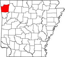
 Pilgrim's Rest, Arkansas  Pilgrim's Rest, Arkansas Pilgrim's Rest's position in Arkansas. | |
| Coordinates: 36°11′14″N 93°59′39″W / 36.18722°N 93.99417°WCoordinates: 36°11′14″N 93°59′39″W / 36.18722°N 93.99417°W | |
| Country |
|
| State |
|
| County | Washington |
| Township | Brush Creek |
| Elevation | 425 m (1,394 ft) |
| Time zone | Central (CST) (UTC-6) |
| • Summer (DST) | CDT (UTC-5) |
| Area code(s) | 479 |
| GNIS feature ID | 77999 |
| U.S. Geological Survey Geographic Names Information System: Pilgrim's Rest, Arkansas | |
Pilgrim's Rest, Arkansas (also Nob Hill, Arkansas) is an unincorporated community in Brush Creek Township, Washington County, Arkansas, United States.[1]
References
- ↑ "Feature Detail Report for: Pilgrim's Rest, Arkansas." USGS. U.S. Geological Survey Geographic Names Information System: Pilgrim's Rest, Arkansas Retrieved September 12, 2010.
This article is issued from Wikipedia - version of the 7/29/2016. The text is available under the Creative Commons Attribution/Share Alike but additional terms may apply for the media files.