Pinkie Road
| Pinkie Road | |
|---|---|
 | |
| Route information | |
|
Maintained by Ministry of Highways and Infrastructure & Transport Canada | |
| Length: | 26 km[1] (16 mi) |
| Existed: | 2009 – present |
| Major junctions | |
| South end: |
|
|
| |
| North end: |
|
| Location | |
| Major cities: | Regina |
| Highway system | |
| Provincial highways in Saskatchewan | |
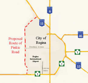
Pinkie Road is a proposed 4 lane twinned highway connector road linking two National Highway System routes as a part of the Asia-Pacific Gateway and Corridor Initiative (APGCI). Highway 1 (the Trans-Canada Highway) and Highway 11 will be linked by this new route, west of Regina, Saskatchewan. The City of Regina, Sherwood No. 159 rural municipality (RM) Ministry of Highways and Infrastructure (MHI) and Transport Canada have come together to begin construction of Pinkie Road which will provide access to an inland port comprising a global communications hub, the Canadian Pacific Railway intermodal facility, Regina International Airport, as well as a warehouse and industrial area. Located northwest the city, the partners are evaluating the environmental concerns, national building requirements as well as feasibility for interchanges, lanes and speeds dependent on proposed Annual Average Daily Traffic amounts. The Regina Regional Economic Development Authority's president and CEO, Larry Hiles, said that "Regina is ideally situated with regard to both geography and infrastructure for this type of development."[2]
Travel route
Pinkie Road is a proposed Saskatchewan Highway 1-to-Highway 11 connector road west of Regina, Saskatchewan. The highway will run from Highway 1 north to the junction with Highway 730 (Dewdney Avenue West) and finally connect with Highway 11. Pinkie Road will run west of the Regina International Airport, with three proposed alignments being studied.[3]
History
Pinkie Road will be a primary access highway with access points for the Global Transportation Hub (GTH). The project is undertaken by the City of Regina, Sherwood No. 159 rural municipality (RM) Ministry of Highways and Infrastructure (MHI) and Transport Canada to provide an Intermodal freight transport center and the road infrastructure between two National Highway System routes.[4] C$27 million will be contributed by the Government of Canada as part of the Asia-Pacific Gateway and Corridor Initiative (APGCI) towards this $93 million project.[5] The provincial government will commit about $27 million to the project.[6] Former Highways and Infrastructure Minister Wayne Elhard discussed expanding the Government's role in the next phase of the development project.[7] The average vehicles per day (vpd) on both Hwy 1 and Hwy 11 were examined in 5 year, and 25 year projections. The traffic on Hwy 1 is expected to have an average of 10,140 / 11,210 vpd on the west and east side of the proposed interchange in five years. This amount in 25 years is expected to increase to 21,040 vpd on the west and 31, 340 vpd on the east side of the proposed interchange respectively. Hwy 11 is projected to increase from 13,060 to 23870 vpd in 25 years.

The new connector road across Dewdney Avenue will carry 5,500 vpd projected in 5 years increasing to 33,000 vpd in 25 years.[8] Currently the Average Annual Daily Traffic (AADT) on Hwy 1 is 9,280 vpd west of Pinkie Road, and 11,680 on the east side of Pinkie Road. On Hwy 11 east of the interchange the AADT is 8,840. On Pinkie Road south of the interchange the traffic volume is 7,740 vpd.[3][9] John Law, deputy minister of Highways and Infrastructure estimated that it will cost about $45 million to upgrade service roads to Pinkie Road and the intermodal facility to support approximately 1,400 commercial trucks per week in the area.[10] The current proposal is looking at a 4 lane twinned highway with service roads. It will become part of the long term bypass route around Regina, and will accommodate future growth of the city to a population of 300,000.[3][11] Pinkie Road will be approximately 26 kilometres (16 mi) in length.[1] The annexation of land by the city from the RM of Sherwood is being negotiated and the city will pay about $1,500,000 and supply water to the RM for the land segment.[12][13]
The city initially considered four industrial land options for development Argyle Park - IPSCO lands, Regina Airport, Ross Industrial Park and the Pinkie Road and Trans-Canada Highway areas.[14][15] In November 2007, Regina City Council examined a report which studied projected industrial growth for the city of Regina until 2027. The study proposed a new industrial area west of the Regina airport. The major roads would be constructed by the Ministry of Highways and Infrastructure and they would be supported by a $7 million payment by the City of Regina. The city also examined at this concept plan the cost of $54 million for infrastructure servicing of facilities.[16] Regina's general manager of corporate services is looking at servicing fees and development levies to help repay the loan.[17] A 20 year time frame will extend land use to also include a light industrial park.[16] A number of open houses were held with the public to determine planning, road alignments, access points and general location of the new connector road.[18] Following the advisement of two consultation firms the City of Regina has determined to proceed with the land development and water, drainage, and wastewater management procedures outlined for the Regina Inland Port. There will be two phases of land development the land development west of Pinkie Road will constitute phase 1 and east of Pinkie Road will be Phase 2.[19]
Intermodal facility
The Canadian Pacific Railway (CPR) intermodal facility (IMF) currently located in Regina's downtown will be re-located west of the city which will enable the CPR to expand its facilities at a new location enabling a more efficient staging of trains.[4] The Regina Regional Economic Development Authority RREDA has worked on establishing Regina as a transportation hub, and this inland port brings together air, road and rail travel services for the export and import of goods.[2] The CPR IMF will be joined by Loblaws Company Limited $200-million western Canadian distribution facility.[20][21] The multimodal hub will encourage North American trade and world distribution, transportation, imports and exports.[22]
Environmental and heritage impact

The proposal is studying the impact the new roadway will have on protected species of fauna in Saskatchewan such as the burrowing owl (Athene cunicularia), loggerhead shrike (Lanius ludovicianus), Sprague's pipit {Anthus spragueii}, peregrine falcon (Falco peregrinus), yellow rail (Coturnicops noveboracensis), monarch butterfly (Danaus plexippus)]] and northern leopard frog (Rana pipiens). Flora of Saskatchewan which may be impacted would be the prairie ragwort (Senecio plattensis) and Geyer's onion (Allium geyeri). The Presbyterian Indian Residential School Cemetery is also located in this vicinity north of Dewdney Avenue and east of Pinkie Road.[23] The project is being planned to meet any requirements set forth under the Building Canada Plan as well as evaluation of project procedures for environmental concerns as set out by the Canadian Environmental Assessment Act.[24]
Intersections south to north
Length is approximate based on local roads currently existing.
| Rural municipality | Location | km[1] | mi | Destinations | Notes |
|---|---|---|---|---|---|
| Sherwood No. 159 | Regina | 0 | 0.0 | ||
| 3 | 4.8 | ||||
| 26 | 42 | ||||
| 1.000 mi = 1.609 km; 1.000 km = 0.621 mi | |||||
See also
References
- 1 2 3 Microsoft Streets and Tips (Map) (2004 ed.). Microsoft Corporation Redmond Washington.
- 1 2 "Dealing with the Labour Shortage - Canadian Pacific Intermodal Facility" (pdf). Regina and District Chamber of Commerce. 2007. Retrieved 2009-02-09.
- 1 2 3 "Proposed Alignments Diagram of proposed alignments" (pdf). About Highways/Transportation Hub/Saskatchewan's Global Transportation Hub. Government of Saskatchewan. Retrieved 2009-02-09.
- 1 2 "Saskatchewan's Global Transportation Hub". About Highways/Transportation Hub/. Government of Saskatchewan. Retrieved 2009-02-09.
- ↑ "The Government of Canada and the Province of Saskatchewan invest in Infrastructure". Transport Canada > Media Room > News Release >. Government of Canada. Retrieved 2009-02-09.
- ↑ Hall, Angela (January 6, 2009). "Plans for 'global transportation hub' growing". Leader Post. Canwest Publishing Inc. Retrieved 2009-02-09.
- ↑ "More cash for growing transport facility". Leader Post. Canwest Publishing Inc. January 6, 2009. Retrieved 2009-02-09.
- ↑ "Forecast Daily Traffic Volumes Diagram illustrated forecasted traffic volumes on Pinkie Road" (pdf). About Highways/Transportation Hub/Saskatchewan's Global Transportation Hub. Government of Saskatchewan. Retrieved 2009-02-09.
- ↑ "Highway Traffic Volume Map trafficvolume-2007.pdf ( 1.5 MB )" (pdf). About Highways/Saskatchewan Maps. Government of Saskatchewan. Retrieved 2009-02-09.
- ↑ "Loblaw announces plans to build a distribution centre". Leader Post - Canwest Publishing. Global Transportation Hub (Regina) - SkyscraperPage Forum. January 6, 2009. Retrieved 2009-02-09.
- ↑ "Study Schedule Timeline for the Pinkie Road study" (pdf). About Highways/Transportation Hub/Saskatchewan's Global Transportation Hub. Government of Saskatchewan. Retrieved 2009-02-09.
- ↑ Rhodes, Veronica (November 4, 2008). "Mayor banking on approval of annexation". The Leader-Post - Can west publishing. Saskatchewan Urban Municipalities Association - iCompass Technologies Inc. Retrieved 2009-02-09.
- ↑ Blackwell, Justin (January 29, 2008). "It's a Go For the Global Transportation Hub". News Talk 650. Rawlco Radio. Retrieved 2009-02-09.
- ↑ Smith, Geoff (January 20, 2009). "Avison Young Forecasts More Growth for Regina". Newstalk radio 980. Rawlco Radio. City of Regina. Retrieved 2009-02-22.
- ↑ "Newsletter Fall Winter 2007/2008" (PDF). Avison Young Intelligent Real Estate Solutions. Retrieved 2009-02-09.
- 1 2 "EX08-46 - International Report - IMF Industrial Expansion Area Concept Plan" (pdf). Regina. Sep 17, 2008. Retrieved 2009-02-09.
- ↑ Rhodes, Veronica (November 3, 2008). "City planning for inland port project". The Leader-Post - Canwest Publishing. Saskatchewan Uban Municipalities Association - iCompass Technologies Inc. Retrieved 2009-02-09.
- ↑ Land Use and Servicing Plans for the Regina Inland Port (pdf) (Map). City of Regina. Nov 2008. Retrieved 2009-02-22.
- ↑ November 5, 2008 RPC08-62 To: Members, Regina Planning Commission (pdf) (Map). City of Regina. Nov 5, 2008. Retrieved 2009-02-22.
- ↑ "Major National Goods Distributor chooses Saskatchewan as its new Distribution Hub". About Government/News Releases/July 2008/. Government of Saskatchewan. Retrieved 2009-02-09.
- ↑ "Loblaw announces plans to build a distribution centre growing". Leader Post. Canwest Publishing Inc. February 9, 2009. Retrieved 2009-02-09.
- ↑ "Transportation - RREDA - Regina Regional Economic Development Authority". Regina Regional Economic Development Authority. 2007. Retrieved 2009-02-09.
- ↑ "Environment and Heritage concerns Discussion of potential heritage and environmental concerns" (pdf). About Highways/Transportation Hub/Saskatchewan's Global Transportation Hub. Government of Saskatchewan. Retrieved 2009-02-09.
- ↑ "Regina becoming transportation hub - Vive" (pdf). Vive le Canada. December 8, 2008. Retrieved 2009-02-09.
External links
| British Columbia | ||
|---|---|---|
| Alberta | ||
| Saskatchewan | ||
| Manitoba | ||
| Ontario | ||
| Quebec | ||
| New Brunswick | ||
| Prince Edward Island | ||
| Nova Scotia | ||
| Newfoundland | ||
| ||