Anderson, Indiana
| Anderson, Indiana | |
|---|---|
| City | |
| City of Anderson | |
|
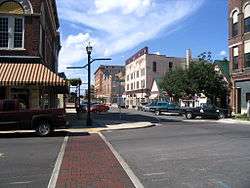
Downtown Anderson | |
| Motto: Performance. Talent. Inspiration. | |
 Location in the state of Indiana | |
| Coordinates: 40°6′0″N 85°40′53″W / 40.10000°N 85.68139°WCoordinates: 40°6′0″N 85°40′53″W / 40.10000°N 85.68139°W | |
| Country | United States |
| State | Indiana |
| County | Madison |
| Townships |
Anderson (Primarily) |
| Government | |
| • Mayor | Thomas Broderick, Jr. (D) |
| Area[1] | |
| • Total | 41.48 sq mi (107.43 km2) |
| • Land | 41.37 sq mi (107.15 km2) |
| • Water | 0.11 sq mi (0.28 km2) |
| Elevation[2] | 879 ft (268 m) |
| Population (2010)[3] | |
| • Total | 56,129 |
| • Estimate (2014)[4] | 55,554 |
| • Density | 1,356.8/sq mi (523.9/km2) |
| Time zone | EST (UTC−5) |
| • Summer (DST) | EDT (UTC−4) |
| ZIP codes | 46011-46018 |
| Area code | 765 |
| FIPS code[2][5] | 18-01468 |
| GNIS ID[2][5] | 430152 |
| Website | www.cityofanderson.com |
Anderson is a city in and the county seat of Madison County, Indiana, United States.[6] It is the principal city of the Anderson, Indiana Metropolitan Statistical Area which encompasses Madison County. Anderson is the headquarters of the Church of God (Anderson) and home of Anderson University, which is affiliated with that denomination. Highlights of the city include the historic Paramount Theatre and the Gruenewald Historic House.
The population was 56,129 at the 2010 census.[7] This is down from 70,000 in 1970.[8]
History
Prior to the organization of Madison County, William Conner entered the land upon which Anderson is located. Conner later sold the ground to John and Sarah Berry, who donated 32 acres (129,000 m²) of their land to Madison County on the condition that the county seat be moved from Pendleton to Anderson. John Berry laid out the first plat of Anderson on November 7, 1827. In 1828 the seat of justice was moved from Pendleton to Anderson.
The city is named for Chief William "Adam" Anderson, whose mother was a Delaware Indian and whose father was of Swedish descent. Chief Anderson's Indian name was Kikthawenund meaning "creaking boughs".[9] The Delaware village was known as Anderson's Town, though the Moravian Missionaries called it "The Heathen Town Four Miles Away." Anderson was also known as Andersonton before being formally organized as Anderson.
Introduction of internal improvements by the Mammoth Internal Improvement Act caused a growth in the population in 1837. In December, 1838, Anderson was incorporated as a town with 350 inhabitants. The Central Canal, a branch of the Wabash and Erie Canal, was planned to come through Anderson. Work continued on the canal during 1838 and the beginning of 1839, but work on the canal was soon suspended by the state following the Panic of 1837. The town again became a sleepy village until 1849 when it was incorporated a second time as a town. Many new commercial ventures located around the Courthouse Square.
This incorporation was short-lived and Anderson once again went back to village status in 1852. However, with the completion of the Indianapolis Bellefontaine Railroad, as well as their station in 1852, Anderson burst to life. The third incorporation of Anderson as a town occurred on June 9, 1853. The population continued to increase. On August 28, 1865, with a population was nearly 1,300 people, Anderson was incorporated as a city.
Between 1853 and the late 19th century, twenty industries of various sizes located there. On March 31, 1887, natural gas was discovered in Anderson. As the Indiana Gas Boom began, this discovery led new businesses that could use natural gas, such as glass-making, to move to the city. Anderson grew to such proportions that a Cincinnati newspaper editor labeled the city "The Pittsburgh on White River." Other appellations were "Queen City of the Gas Belt" and (because of the vulcanizing and the rubber tire manufacturing business) "Puncture Proof City."
In 1897 the Interurban Railroad was born in Anderson. Charles Henry, a large stock holder, coined the term "Interurban" in 1893. It continued to operate until 1941. The year 1912 spelled disaster for Anderson: the natural gas ran out, due to the residents squandering their resources. The city left its gas powered lights on day and night, and there are stories of a pocket of natural gas being lit in the river and burning for a prolonged period for the spectacle of it. The result of the loss of natural gas was that several factories moved out. The whole city slowed down. The Commercial Club (formed on November 18, 1905) was the forerunner of the present chamber of commerce.
This club persuaded the Remy brothers to stay in Anderson and others to locate there. For decades, Delco Remy and Guide Lamp, during World War II built the M3, M3a1 submachine gun and the liberator pistol for the allies, (later Fisher Guide) were the top two employers in the city. From 1913 through the 1950s, the Ward-Stilson Company was one of the country's largest producers of uniforms, regalia, furniture and props for the Freemasons, the Odd Fellows and dozens of other U.S. fraternal organizations.
The Church of God of Anderson located its world headquarters in Anderson in 1905. Anderson Bible School was opened in 1917, and this was separated from Gospel Trumpet (now known as Warner Press) in 1925. At the same time, it became known as Anderson Bible School and Seminary. In 1925, the name was changed to Anderson College and then to Anderson University in 1988.
Over the years, 17 different types of automobiles were manufactured in Anderson with the Lambert family among the city's leaders in its development and Buckeye Gasoline Buggy the Lambert product. Many other inventions were perfected in Anderson including: the gas regulator (Miron G. Reynolds), the stamp vending machine (Frank P. Dunn), clothes presser (H. Donald Forse), "Irish Mail" handcars (Hugh Hill), flower car for funeral homes (Francis M. McClain, automatic gearshift (Von D. Polhemus)), Sisson choke (Glenn Sisson), and the vulcanizing process to retread tires (Charles E. Miller).
Geography
Anderson is located at 40°06′00″N 85°40′53″W / 40.100041°N 85.681525°W.[10] The city of Anderson is located in parts of six townships: Anderson, Union, Richland, Lafayette, Adams, and Fall Creek.
According to the 2010 census, Anderson has a total area of 41.479 square miles (107.43 km2), of which 41.37 square miles (107.15 km2) (or 99.74%) is land and 0.109 square miles (0.28 km2) (or 0.26%) is water.[1]
Climate
| Climate data for Anderson, Indiana | |||||||||||||
|---|---|---|---|---|---|---|---|---|---|---|---|---|---|
| Month | Jan | Feb | Mar | Apr | May | Jun | Jul | Aug | Sep | Oct | Nov | Dec | Year |
| Record high °F (°C) | 69 (21) |
72 (22) |
85 (29) |
90 (32) |
96 (36) |
104 (40) |
105 (41) |
102 (39) |
103 (39) |
92 (33) |
81 (27) |
75 (24) |
105 (41) |
| Average high °F (°C) | 32.3 (0.2) |
36.5 (2.5) |
48.1 (8.9) |
60.7 (15.9) |
71.6 (22) |
80.6 (27) |
83.7 (28.7) |
81.6 (27.6) |
75.7 (24.3) |
63.9 (17.7) |
50.4 (10.2) |
37.1 (2.8) |
60.2 (15.7) |
| Average low °F (°C) | 17.4 (−8.1) |
20.9 (−6.2) |
31.5 (−0.3) |
40.3 (4.6) |
50 (10) |
59.3 (15.2) |
63.2 (17.3) |
61.1 (16.2) |
54.3 (12.4) |
43.1 (6.2) |
34.4 (1.3) |
23.5 (−4.7) |
41.6 (5.3) |
| Average rainfall inches (cm) | 2 (5) |
2.2 (5.6) |
3.5 (8.9) |
4 (10) |
3.8 (9.7) |
3.5 (8.9) |
4.1 (10.4) |
3.4 (8.6) |
3.1 (7.9) |
2.6 (6.6) |
3.3 (8.4) |
3.1 (7.9) |
38.5 (97.8) |
| Average snowfall inches (cm) | 6 (15) |
5.7 (14.5) |
2.3 (5.8) |
0.3 (0.8) |
0 (0) |
0 (0) |
0 (0) |
0 (0) |
0 (0) |
0 (0) |
0.8 (2) |
4.8 (12.2) |
19.2 (48.8) |
| Source #1: [11] | |||||||||||||
| Source #2: [12] | |||||||||||||
Demographics
| Historical population | |||
|---|---|---|---|
| Census | Pop. | %± | |
| 1850 | 5,727 | — | |
| 1860 | 6,527 | 14.0% | |
| 1870 | 9,186 | 40.7% | |
| 1880 | 11,425 | 24.4% | |
| 1890 | 10,019 | −12.3% | |
| 1900 | 20,178 | 101.4% | |
| 1910 | 22,476 | 11.4% | |
| 1920 | 29,767 | 32.4% | |
| 1930 | 39,804 | 33.7% | |
| 1940 | 41,572 | 4.4% | |
| 1950 | 46,820 | 12.6% | |
| 1960 | 49,061 | 4.8% | |
| 1970 | 70,787 | 44.3% | |
| 1980 | 64,695 | −8.6% | |
| 1990 | 59,459 | −8.1% | |
| 2000 | 59,734 | 0.5% | |
| 2010 | 56,129 | −6.0% | |
| Est. 2015 | 55,305 | [13] | −1.5% |
| Source: US Census Bureau | |||
2010 census
As of the 2010 census,[3] there were people, households, and families residing in the city. The population density was 1,356.8 inhabitants per square mile (523.9/km2). There were housing units at an average density of 675.7 per square mile (260.9/km2). The racial makeup of the city was 78.8% White, 15.2% African American, 0.3% Native American, 0.5% Asian, 2.6% from other races, and 2.6% from two or more races. Hispanic or Latino of any race were 4.8% of the population.
Of the extant households 28.8% had children under the age of 18 living with them, 35.8% were married couples living together, 17.1% had a female householder with no husband present, 5.5% had a male householder with no wife present, and 41.6% were non-families. 34.5% of all households were made up of individuals and 13.8% had someone living alone who was 65 years of age or older. The average household size was 2.28 and the average family size was 2.91.
The median age in the city was 37.8 years. 22.4% of residents were under the age of 18; 11.5% were between the ages of 18 and 24; 24.8% were from 25 to 44; 24.9% were from 45 to 64; and 16.3% were 65 years of age or older. The gender makeup of the city was 47.9% male and 52.1% female.
2000 census
As of the 2000 census,[14] there were people, households, and families residing in the city. The population density was 1,491.6 people per square mile (575.9/km²). There were housing units at an average density of 690.3 per square mile (266.5/km²). The racial makeup of the city was 81.99% White, 14.88% African American, 0.31% Native American, 0.49% Asian, 0.02% Pacific Islander, 0.86% from other races, and 1.45% from two or more races. Hispanic or Latino of any race were 2.07% of the population.
There were 25,274 households out of which 27.0% had children under the age of 18 living with them, 41.4% were married couples living together, 15.1% had a female householder with no husband present, and 39.0% were non-families. 33.1% of all households were made up of individuals and 14.0% had someone living alone who was 65 years of age or older. The average household size was 2.28 and the average family size was 2.87.
In the city the age distribution of the population shows 23.2% under the age of 18, 11.2% from 18 to 24, 27.6% from 25 to 44, 21.3% from 45 to 64, and 16.6% who were 65 years of age or older. The median age was 36 years. For every 100 females there
Government
The city government consists of a mayor and a city council. The mayor is elected in citywide vote. The city council consists of nine members. Six are elected from individual districts. Three members are elected at large.
Economy
When General Motors closed its operations in Anderson, the city was dealt a major economic blow as GM was the biggest employer in Anderson.[15] Nevertheless, in 2007, Anderson was ranked 98th in the Forbes List for 100 Best Places for Businesses among Smaller U.S. Metro areas.[16] However, a more recent (2014) appraisal of Anderson from the Indiana Business Review was mixed noting that "long-term trends are negative", citing "a long-term downward trend in area employment" and "acceleration in the number of food stamp recipients". More recent unemployment has been reduced, but improvements still lag behind the rest of the state.[17]
For 2013, estimated household median income was $33,574 (vs. Indiana state median of $48,248). Per capita money income was $18,216 (Indiana per capita of $24,635). 25.8% of the city's population was estimated at living below poverty level, vs. a statewide estimation of 15.4%.[18] Madison County, of which Anderson is the seat, has nearly three times as many food stamps recipients per capita as does Indiana as a whole.[19][20]
As of June 2014, the ten largest employers in Madison County were:[21]
| Rank | Employer | # of employees |
|---|---|---|
| 1 | Community Hospital Anderson | 1,225 |
| 2 | St. Vincent Health | 1,124 |
| 3 | Nestlé | 700 |
| 4 | Carter Express | 650 |
| 5 | Hoosier Park | 623 |
| 6 | Anderson University | 500 |
| 7 | Xerox | 500 |
| 8 | Walmart | 400 |
| 9 | Kroger/Pay Less Super Markets | 375 |
| 10 | Ricker Oil Company | 270 |
Points of interest
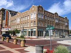
- Downtown Historic District
- Paramount Theatre
- Mounds State Park
- Anderson Speedway
- Hoosier Park Racing and Casino
- Shadyside Memorial Park and Lake
- The Anderson Center for the Arts
- Madison County Historical Center
- In addition to Downtown Historic District, Paramount Theatre, Mounds State Park, and The Anderson Center for the Arts, the Anderson Bank Building, Central Avenue School, Gruenewald House, Tower Hotel, West Central Historic District, and West Eighth Street Historic District are listed in the National Register of Historic Places.[22]
Education
Anderson's public school district is the Anderson Community School Corporation, which includes one high school, Anderson High School which serves grades 9 – 12; one junior high school, Highland Junior High School (formerly Highland High School) which serves grades 6 – 8, six elementary schools (Eastside, Edgewood, Valley Grove, 10th Street, Erskine, Anderson Elementary) which serve k -5, a kindergarten center (Killbuck), and a preschool (Southview). Until 1997, Anderson had three high schools: Highland, Madison Heights and Anderson. In 1997 Madison Heights was closed and Anderson High School moved into that facility. Beginning in the fall of 2010, Highland High School closed and was converted into a junior high school, consolidating all students in grades 9-12 into Anderson High School.
Anderson also has a charter school (non-traditional, tuition-free public school) called Anderson Preparatory Academy. Currently, Anderson Preparatory Academy features grades K-12. Anderson Preparatory Academy is a college preparatory, military-based academy. All cadets in grades 6-8 are members of the Civil Air Patrol. High school cadets are all members of the Air Force JROTC program. Original plans called to only offer grades 6-9, then add on another upper grade each year before extending the lower years.
Anderson University and Ivy Tech Community College of Indiana are also located within the city.
In fiction
In the comic strip Peanuts, a book in the fictional series beloved by Snoopy, "The Six Bunny Wunnies", is called The Six Bunnie-Wunnies and Their Layover in Anderson, Indiana. (Charles Schulz had been recently awarded an honorary degree by Anderson College.)
Anderson is the home of several characters in the alternate history novel The Man with the Iron Heart by Harry Turtledove.
Notable people
- Matthew W. Allen, Actor
- Jermaine Allensworth, athlete
- Lowell Amos, convicted "Black Widower" murderer
- Melvin E. Biddle, World War II Medal of Honor recipient
- Don Brandon, Hall of Fame Baseball Coach from Anderson University
- Jann Browne, Country music singer
- Gary Burton, jazz vibraphonist
- Bob Carey, Indy car driver
- Everett Case, nicknamed "Gray Fox", basketball coach notable for his tenure at North Carolina State University, 1946–1964
- Buck Crouse, MLB catcher
- James Davis, politician, Secretary of Labor
- Winfield T. Durbin, politician, former Governor of Indiana
- Cory Edwards, producer of Hoodwinked! and Hoodwinked Too! Hood vs. Evil; created the internet series Krogzilla on Smosh's Shut Up Cartoons channel
- Carl Erskine, former MLB pitcher for the Brooklyn & Los Angeles Dodgers
- Krystal Harris, singer
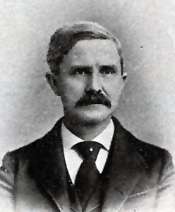
- Charles L. Henry, politician, congressman, coiner of the term "interurban"
- Orville Hodge, embezzler
- James Kilgore, Symbionese Liberation Army member
- John William Lambert, inventor of first successful U.S. gasoline automobile
- Adam Lind, MLB player for Seattle Mariners
- Matt Lutz, actor
- Von Mansfield, NFL defensive back
- Brittany Mason, Teen Model USA 2004, Miss Indiana USA 2008, International Model
- Mack Mattingly, politician, Georgia senator
- Jon McLaughlin, singer
- Phyllis Reynolds Naylor, author
- Phill Niblock, composer and filmmaker
- Sandi Patty, singer
- James Rebhorn, actor
- Brian Reed, comic book writer
- Robert L. Rock, Mayor of Anderson, Lieutenant Governor of Indiana
- Kris Roe (The Ataris), singer
- Fred Mustard Stewart, author
- Kevin Stein, Poet Laureate of Illinois
- Max Terhune, actor
- Ray Tolbert, basketball player for Indiana's 1981 NCAA championship team
- Albert Henry Vestal, majority whip of the House of Representatives, 1923–1931
- Len Walston, singer-songwriter and music producer
- Louis J. Weichmann
- Bob Wilkerson, basketball player for Indiana's undefeated 1976 NCAA championship team
- Jumping Johnny Wilson, athlete
- Amber Portwood, TV personality, one of the original cast members from MTV's Teen Mom
References
- 1 2 "G001 - Geographic Identifiers - 2010 Census Summary File 1". United States Census Bureau. Retrieved 2015-07-28.
- 1 2 3 "Feature ID 430152". Geographic Names Information System. United States Geological Survey. Retrieved June 30, 2014.
- 1 2 "American FactFinder". United States Census Bureau. Retrieved 2012-12-11.
- ↑ "QuickFacts: Anderson, Indiana". United States Census Bureau. Retrieved 2016-03-29.
- 1 2 "FIPS55 Data: Indiana". FIPS55 Data. United States Geological Survey. February 23, 2006. Archived from the original on June 18, 2006. Retrieved June 30, 2014. External link in
|work=(help) - ↑ "Find a County". National Association of Counties. Archived from the original on May 31, 2011. Retrieved 2011-06-07.
- ↑ Brattain, Sam (2011-10-01). "APD measures manpower carefully". Herald Bulletin. Retrieved 2011-10-02.
- ↑ Peters, J. W.; Maynard, M. (February 20, 2006). "A town in danger of dying out as GM falters". New York Times. Retrieved June 8, 2014.
- ↑ http://www.andersonmchs.com/chief-anderson.php
- ↑ "US Gazetteer files: 2010, 2000, and 1990". United States Census Bureau. 2011-02-12. Retrieved 2011-04-23.
- ↑ "Weatherbase". Weatherbase. Retrieved January 3, 2011.
- ↑ "The Weather Channel". Retrieved January 3, 2011.
- ↑ "Annual Estimates of the Resident Population for Incorporated Places: April 1, 2010 to July 1, 2015". Retrieved July 2, 2016.
- ↑ "American FactFinder". United States Census Bureau. Archived from the original on September 11, 2013. Retrieved 2008-01-31.
- ↑ Peters, Jeremy W.; Maynard, Micheline (February 20, 2006). "Company Town Relies on G.M. Long After Plants Have Closed". The New York Times.
- ↑ "100 best Places for Businesses among Smaller U.S. Metro areas". Forbes. May 2007. Archived from the original on February 26, 2009. Retrieved 2009-03-20.
- ↑ "Anderson Forecast 2015". 2014. Retrieved 2014-12-31.
- ↑ "State & County Quick Facts, Anderson (city), Indiana". 2014. Retrieved 2014-12-31.
- ↑ "Madison County, Indiana". 2014. Retrieved 2014-12-31.
- ↑ "Indiana". 2014. Retrieved 2014-12-31.
- ↑ "Leading Employers". Madison County Corporation for Economic Development. 2014. Retrieved 2014-06-27.
- ↑ National Park Service (2010-07-09). "National Register Information System". National Register of Historic Places. National Park Service.
External links
| Wikivoyage has a travel guide for Anderson (Indiana). |
| Wikimedia Commons has media related to Anderson, Indiana. |
- City website
- History of Anderson, Indiana
- Interactive Map of Anderson, Indiana
- Anderson Public Library
- The Herald Bulletin
Municipalities and communities of Madison County, Indiana, United States | ||
|---|---|---|
| Cities | ||
| Towns | ||
| Townships | ||
| Unincorporated communities |
| |
| Footnotes | ‡This populated place also has portions in an adjacent county or counties | |