Ploemeur
| Ploemeur Plañvour | ||
|---|---|---|
|
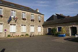
The town hall in Ploemeur | ||
| ||
 Ploemeur | ||
|
Location within Brittany region  Ploemeur | ||
| Coordinates: 47°44′14″N 3°25′34″W / 47.7372°N 3.4261°WCoordinates: 47°44′14″N 3°25′34″W / 47.7372°N 3.4261°W | ||
| Country | France | |
| Region | Brittany | |
| Department | Morbihan | |
| Arrondissement | Lorient | |
| Canton | Ploemeur | |
| Intercommunality | Pays de Lorient | |
| Government | ||
| • Mayor (2014 — 2020) | Ronan Loas | |
| Area1 | 39.72 km2 (15.34 sq mi) | |
| Population (1999)2 | 18,304 | |
| • Density | 460/km2 (1,200/sq mi) | |
| Time zone | CET (UTC+1) | |
| • Summer (DST) | CEST (UTC+2) | |
| INSEE/Postal code | 56162 / 56270 | |
| Elevation | −1–55 m (−3.3–180.4 ft) | |
|
1 French Land Register data, which excludes lakes, ponds, glaciers > 1 km² (0.386 sq mi or 247 acres) and river estuaries. 2 Population without double counting: residents of multiple communes (e.g., students and military personnel) only counted once. | ||
Ploemeur (Plañvour in Breton) is a commune in the Morbihan department in the region of Brittany in north-western France.
The inhabitants are called the Ploemeurois.
Breton language
The municipality launched a linguistic plan through Ya d'ar brezhoneg on 18 April 2006.
Etymology
The current name of the city of Ploemeur comes from the old Breton Plo Meur meaning "Big Parish".
Geography
Ploemeur is close to Lorient (Breton: An Oriant), a sub-prefecture of Morbihan.
Photographs of the Port of Lomener
- The pier
- The Island of Groix at the horizon
- End of the day on the port
People
- Stanislas Dupuy de Lôme (1816 in the Château de Soye - †1885), who built the first armored battleship.
- Yoann Gourcuff, born on 11 July 1986, is a footballer of Olympique Lyonnais and of the French national team.
- Diego Yesso footballer
International relations
Twin towns — Sister cities
Ploemeur is twinned with:
See also
References
Notes
- ↑ Infoveriti (2011). "KOMITET MIAST BLIŹNIACZYCH NOWA DĘBA - FERMOY - PLOEMEUR - KRS - InfoVeriti". infoveriti.pl. Retrieved 30 May 2011.
- ↑ Nowa Dęba City Council (2011). "Oficjalna strona Miasta i Gminy Nowa Dęba / Organizacje pozarządowe". nowadeba.pl. Retrieved 30 May 2011.
External links
| Wikimedia Commons has media related to Ploemeur. |
- Official site of Ploemeur
- Unofficial site on the history of Ploemeur and its monuments
- Ploemeur/Plañvour's page on the portal of the towns and cities of Brittany
- French Ministry of Culture list for Ploemeur (French)
This article is issued from Wikipedia - version of the 5/17/2015. The text is available under the Creative Commons Attribution/Share Alike but additional terms may apply for the media files.

.svg.png)