Plouharnel
| Plouharnel Plouharnel | |
|---|---|
|
The Chapel of Our Lady of Flowers, in Plouharnel | |
 Plouharnel | |
|
Location within Brittany region  Plouharnel | |
| Coordinates: 47°35′56″N 3°06′41″W / 47.5989°N 3.1114°WCoordinates: 47°35′56″N 3°06′41″W / 47.5989°N 3.1114°W | |
| Country | France |
| Region | Brittany |
| Department | Morbihan |
| Arrondissement | Lorient |
| Canton | Quiberon |
| Intercommunality | Côte des Mégalithes |
| Government | |
| • Mayor (2008—2014) | Gérard Pierre |
| Area1 | 18.32 km2 (7.07 sq mi) |
| Population (1999)2 | 1,700 |
| • Density | 93/km2 (240/sq mi) |
| Time zone | CET (UTC+1) |
| • Summer (DST) | CEST (UTC+2) |
| INSEE/Postal code | 56168 / 56340 |
| Elevation | 0–33 m (0–108 ft) |
|
1 French Land Register data, which excludes lakes, ponds, glaciers > 1 km² (0.386 sq mi or 247 acres) and river estuaries. 2 Population without double counting: residents of multiple communes (e.g., students and military personnel) only counted once. | |

Plouharnel (Breton: Plouharnel) is a commune in the Morbihan department of Brittany in north-western France.
Demographics
Inhabitants of Plouharnel are called in French Plouharnelais.
Monuments
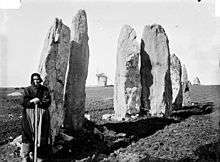
The Vieux Moulin stones.
Photograph by Zacharie Le Rouzic (1864-1939)
Photograph by Zacharie Le Rouzic (1864-1939)
The commune contains a number of megalithic monuments including those at Le Vieux-Moulin, comprising six stones weighing up to ten tons.[1]
See also
References
- ↑ Aubrey Burl, From Carnac to Callanish: The Prehistoric Stone Rows and Avenues of Britain, Ireland, and Brittany, Yale University Press, 1993 , p.1
External links
| Wikimedia Commons has media related to Plouharnel. |
- Official website (French)
- French Ministry of Culture list for Plouharnel (French)
- Map of Plouharnel on Michelin (English)
This article is issued from Wikipedia - version of the 2/18/2016. The text is available under the Creative Commons Attribution/Share Alike but additional terms may apply for the media files.