Pluméliau
| Pluméliau Pluniav | ||
|---|---|---|
|
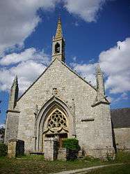
The Chapel of Saint-Nicolas-des-Eaux, in Pluméliau | ||
| ||
 Pluméliau | ||
|
Location within Brittany region  Pluméliau | ||
| Coordinates: 47°57′30″N 2°58′20″W / 47.9583°N 2.9722°WCoordinates: 47°57′30″N 2°58′20″W / 47.9583°N 2.9722°W | ||
| Country | France | |
| Region | Brittany | |
| Department | Morbihan | |
| Arrondissement | Pontivy | |
| Canton | Baud | |
| Intercommunality | Pays de Baud | |
| Government | ||
| • Mayor (2008—2014) | Daniel Kerbrat | |
| Area1 | 67.72 km2 (26.15 sq mi) | |
| Population (1999)2 | 3,091 | |
| • Density | 46/km2 (120/sq mi) | |
| Time zone | CET (UTC+1) | |
| • Summer (DST) | CEST (UTC+2) | |
| INSEE/Postal code | 56173 / 56930 | |
| Elevation | 33–152 m (108–499 ft) | |
|
1 French Land Register data, which excludes lakes, ponds, glaciers > 1 km² (0.386 sq mi or 247 acres) and river estuaries. 2 Population without double counting: residents of multiple communes (e.g., students and military personnel) only counted once. | ||
.svg.png)
Pluméliau (Breton: Pluniav) is a commune in the Morbihan department of Brittany in north-western France.
Geography
The ruisseau de Kergouët forms part of the commune's eastern border, then flows into the Ével, which forms its south-eastern border.
Demographics
Inhabitants of Pluméliau are called in French Plumelois.
See also
- Communes of the Morbihan department
- Henri_Gouzien, sculptor of Pluméliau War Memorial
References
External links
| Wikimedia Commons has media related to Pluméliau. |
- Cultural Heritage (French)
- Map of Pluméliau on Michelin (English)
This article is issued from Wikipedia - version of the 3/15/2016. The text is available under the Creative Commons Attribution/Share Alike but additional terms may apply for the media files.