Police, Poland
| Police | |||
|---|---|---|---|
|
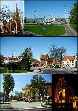
Police; Top left: Saint Mary's Church, Top right: Kuznicka industrial complex area, Center: Rynek Square, Bottom left: Anny Jagiellonki New Town, Bottom right: A night view of a gothic chapel in Chrobry Square | |||
| |||
 Police | |||
| Coordinates: 53°32′N 14°34′E / 53.533°N 14.567°E | |||
| Country |
| ||
| Voivodeship | West Pomeranian | ||
| County | Police County | ||
| Gmina | Gmina Police | ||
| Government | |||
| • Mayor | Władysław Diakun | ||
| Area | |||
| • Total | 36.84 km2 (14.22 sq mi) | ||
| Population (2014) | |||
| • Total | 41,745 | ||
| • Density | 1,100/km2 (2,900/sq mi) | ||
| Time zone | CET (UTC+1) | ||
| • Summer (DST) | CEST (UTC+2) | ||
| Postal code | 72-009, 72-010, 72-011 | ||
| Car plates | ZPL | ||
| Website | http://www.police.pl | ||

Police [pɔˈlʲit͡sɛ] (German: Pölitz; Kashubian/Pomeranian: Pòlice) is a town in the West Pomeranian Voivodeship, northwestern Poland. It is the capital of Police County. As of 2007, the town had 34,220 inhabitants. This is one of the biggest towns of Szczecin agglomeration.
The town is situated on the Oder River and its estuary, south of the Szczecin Lagoon and the Bay of Pomerania. The centre of Police Town is situated about 15 kilometres (9 miles) north of the centre of Szczecin.
The name of the town comes from the Polish pole, which means "field".[1]

History
The settlement was first mentioned in 1243. Pomeranian duke Barnim of Pomerania granted Magdeburg law to the town in 1260.[2][3] At the end of the 13th century, the town had become a fief of a local dynasty of knights, the Drake family.[4] In 1321, with the death of Otto Drake, the town became a dependency of nearby Stettin (now Szczecin),[4] hindering its growth until the mid-18th century.
Nearby Jasienica Abbey, now within the Police city limits, was secularized during the Protestant Reformation, which was adapted in the Duchy of Pomerania in 1534. After its secularization, the abbey became a ducal domain, and was the site of the treaty that for the first time partitioned the duchy into a western and eastern part (Pomerania-Wolgast and Pomerania-Stettin) in 1569.[5]
From the Treaty of Stettin (1630) until the Treaty of Stockholm (1720), Pölitz was part of Swedish Pomerania, and of Prussian Pomerania thereafter. In 1808, Pölitz became independent from Stettin again. In 1815, Pölitz became part of the restructured Province of Pomerania, administered within Landkreis Randow county. In 1939, this county was dissolved and Pölitz was made part of Groß-Stettin.[6]
In 1937, the synthetic fuel plant Hydrierwerke Pölitz AG was founded by IG Farben, Rhenania-Ossag, and Deutsch-Amerikanische Petroleum Gesellschaft[7] which by 1943 was producing 15% of Nazi Germany's synthetic fuels, 577,000 tons.[8] The plant derived its workforce from an adjacent system of camps (Pommernlager, Nordlager, Tobruklager, Wullenwever-Lager, Arbeitserziehungslager Hägerwelle, Dürrfeld Lager) plus a ship moored on the Oder River serving as a camp (Umschulungslager Bremerhaven). In addition, a subcamp of the Stutthof concentration camp was located in Pölitz. During World War II, the plant made Pölitz a bombing target of the Allied Oil Campaign leading to 70% of the town being destroyed.[3][6]
Post-World War II
The city with the plant was captured by the Red Army during the Battle of Berlin on 26 April 1945. While most of the former German territory east of the Oder-Neisse line became Polish, Pölitz, situated on the western bank of the Oder, remained a Soviet-administered exclave: Marshal Zhukov decreed the establishment of a Soviet county with Pölitz, Ziegenort, Jasenitz, Messenthin and Scholwin.[9] 25,000 German workers had to disassemble the plant before it was sent to the USSR.[9] Gradually, the area without the plant was given to Poland: Mścięcino (formerly Messenthin) on 7 September 1946, and Police (formerly Pölitz) with Jasienica (formerly Jasenitz) on 19 September. On 25 February 1947 the plant also passed to Polish control. Polish settlers, partially expellees from the east of former Poland, arrived in the region to replace the German population that had fled or were forcibly expelled. They were joined by refugees from Greece and Yugoslav Macedonia in 1953.
The ruins of the plant still remain standing, though they are not secured and are dangerous to visit.
A large chemical plant (Zakłady Chemiczne "Police") was built in the town in 1969 and has grown since to become one of the largest in Poland. It produces mostly titanium dioxide pigments and nitrogen and phosphorus fertilizers.
Police was in the Szczecin Voivodeship from 1946 to 1998. Since 1999 the town has been part of the West Pomeranian Voivodeship.
Districts
- Police Old Town
- Mścięcino
- Jasienica
- New Town (Nowe Miasto: Osiedle Dąbrówka, Osiedle Gryfitów, Osiedle Księcia Bogusława X, Osiedle Anny Jagiellonki)
Notable buildings from the pre-WW2 era:
- the ruins of Jasienica Abbey, a former Augustinian abbey in Police-Jasienica (14th century)
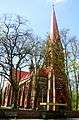
- a Gothic Church in Police-Jasienica (14th/18th century)
- a Gothic Chapel (15th century) in The Chrobry Square in The Old Town
- a Neo-Gothic Church (19th century) in the Old Town
- the Police Lapidary in The Staromiejski Park in the Old Town
- Tenement houses (19th century)
- Town hall (1906) (not rebuilt after WWII)
The tourist and cultural information office is localised in The Gothic Chapel in Bolesław Chrobry Square in The Old Town of Police
Geography and nature

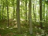
Police is situated on the Oder River and an estuary of the Oder River - Roztoka Odrzańska, south of the Lagoon of Szczecin and the Bay of Pomerania. The centre of Police Town is situated about 15 km (9 mi) north of the centre of Szczecin. Police is at located in the Ueckermünder Heide (Polish: Puszcza Wkrzańska) with the Świdwie Nature Reserve around Lake Świdwie (Polish: Jezioro Świdwie) near Tanowo and Dobra. A kayak route follows the Gunica River from Węgornik through Tanowo, Tatynia and Wieńkowo to Police-Jasienica. At the Szczecin Lagoon (Polish: Zalew Szczeciński, German: Stettiner Haff) is a small yacht marina on the mouth of the Łarpia River (part of Oder) - 'Olimpia'. The ruins of the synthetic petrol plant (Hydrierwerke Pölitz – Aktiengeselschaft) are now a habitat of bats (Barbastelle, Greater mouse-eared bat, Daubenton's Bat, Natterer's bat, Brown long-eared bat).
Population
- 1740: 1,000[3]
- 1850: 2,500[3]
- 1960: 8,900[10]
- 1970: 12,800[10]
- 1975: 17,600[10]
- 1980: 24,800[10]
- 1983: 28,581[3]
- 1990: 34,400
- 1995: 34,456[3]
- 2000: 35,000
- 2004: 41,400
- 2014: 41,745
Infrastructure
Major roads under state control connect Police to Trzebież and Nowe Warpno, No. 114; to Tanowo, No. 114; and to Szczecin over Przęsocin.
Main streets in Police include: ul. Tanowska, ul. Bankowa, ul. Grunwaldzka, ul. Kościuszki, ul. Jasienicka, ul. Dworcowa, ul. Piastów, ul. Wojska Polskiego, ul. Asfaltowa, ul. Cisowa, ul. Piłsudskiego, and ul. Wyszyńskiego.
- Railway:
- Airport in Goleniów, a town behind the Oder River (Szczecin-Goleniów "Solidarność" Airport)
- Public transport:
- 10 bus lines in a town. Bus communication between all districts of a town, a few villages near Police (Trzeszczyn, Tanowo, Siedlice, Leśno Górne, Pilchowo, Przęsocin, LS to Trzebież over Dębostrów, Niekłończyca and Uniemyśl) and Szczecin City.
- Taxicab
-

Ruins of Jasenitz Abbey (14th century)
-

Jasienica Gothic church (14th/18th century)
-

Gothic Chapel (15th century), Old Town
-
Neo-Gothic Church (19th century), Old Town
-
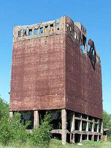
Ruins of the synthetic petrol plant (Hydrierwerke Pölitz – Aktiengeselschaft)
-
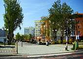
Cisowa Street in Police-Mścięcino
-

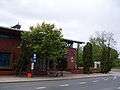
The Main Railway Station in Police
-

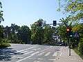
Bus stop in Police
-
Bus stop in Police
Culture and sport
- KP Chemik Police - football club
- KPS Chemik Police - female volleyball club
- Łarpia Sail Festival - shanty music festival - in May, periodic
- Augustinian Fair (Polish: Jarmark Augustiański) in Jasienica - at the end of August, periodic
- Police Nationwide Quarter-Marathon (Ćwierćmaraton Policki) - in October, periodic
- Police Music Days (Polish: Polickie Dni Muzyki "Cecyliada") - in October, periodic
Hospital
A clinic hospital in Police (Siedlecka Street, The New Town, Osiedle Gryfitów) is a part of The Pomeranian Medical University.
Notable residents
- Ludwig Hollonius (1570s-1621), pastor and playwright
- Hans Modrow (born 1928), former premier of East Germany
Major corporations
- Zakłady Chemiczne Police SA
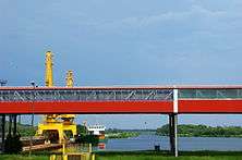
- Port of Police (The Seaport, The Barge Port, The 'Mijanka' cargo berth)
- Industrial Park - Policki Park Przemysłowy (Infrapark Police)
Twinning cities
The sister cities of Police are:[11]
 Pasewalk, Germany
 Novyi Rozdil, Ukraine
Towns near Police
- Szczecin, Poland
- Nowe Warpno, Poland
- Goleniów, Poland
- Eggesin, Germany
- Ueckermünde, Germany
- Pasewalk, Germany
See also
- Villages in Police County: Przęsocin, Kołbaskowo, Trzebież
- Szczecin Lagoon
- Wkrzanska Forest
References
- Notes
- ↑ Kazimierz Rymut, Nazwy miast Polski (Names of towns of Poland), Zakład Narodowy im. Ossolińskich, 1980, pg. 189
- ↑ Rudolf Benl, Die Gestaltung der Bodenrechtsverhältnisse in Pommern vom 12. bis zum 14. Jahrhundert, Böhlau, 1986, p.240, ISBN 3-412-01586-5: "Die deutsche Stadt Pölitz war 1260 von Barnim I. gegründet..."
- 1 2 3 4 5 6 Thomas Gallien, Reno Stutz, Geschichtswerkstatt Rostock, Landesheimatverband Mecklenburg-Vorpommern, Landeskundlich-historisches Lexikon Mecklenburg-Vorpommern, Hinstorff, 2007, p.503
- 1 2 Peter Johanek et al.: Städtebuch Hinterpommern Ausg. 2-3, Kohlhammer, 2003, p.268, ISBN 3-17-018152-1
- ↑ Dietmar Willoweit, Hans Lemberg, Reiche und Territorien in Ostmitteleuropa: historische Beziehungen und politische Herrschaftslegitimation, Oldenbourg Wissenschaftsverlag, 2006, p.96, ISBN 3-486-57839-1
- 1 2 Johannes Hinz, Pommern Lexikon, Kraft, 1994, p.236, ISBN 3-8083-1164-9
- ↑ Rainer Karlsch, Raymond G. Stokes, Faktor Öl: die Mineralölwirtschaft in Deutschland 1859-1974, C. H. Beck, 2003, pp.193ff, ISBN 3-406-50276-8
- ↑ Rainer Karlsch, Raymond G. Stokes, Faktor Öl: die Mineralölwirtschaft in Deutschland 1859-1974, C.H.Beck, 2003, p.196, ISBN 3-406-50276-8
- 1 2 Jan M Piskorski, Pommern im Wandel der Zeit, 1999, p.380, ISBN 978-83-906184-8-7
- 1 2 3 4 Rocznik Statystyczny 1981, Główny Urząd Statystyczny, Warszawa 1981, Rok XLI
- ↑ "Miasta partnerskie" (in Polish). bip.police.pl. Retrieved 2015-01-05.
External links
| Wikimedia Commons has media related to Police (town). |
| Wikivoyage has a travel guide for Police. |
- Official town webpage
- History of Police
- The Factory: Zakłady Chemiczne "Police"
- Police Harbour
- Police on www.city-map.pl
- Jasienica VR360
Coordinates: 53°32′N 14°34′E / 53.533°N 14.567°E
Seat: Police | ||
| Urban-rural gminas |  | |
| Rural gminas | ||
| Town and seat |  | |
|---|---|---|
| Villages | ||