Ponce de Leon Springs State Park
| Ponce de Leon Springs State Park | |
|---|---|
|
IUCN category V (protected landscape/seascape) | |
 | |
| Location | Holmes County, Florida, USA |
| Nearest city | DeFuniak Springs, Florida |
| Coordinates | 30°42′29″N 85°55′37″W / 30.70806°N 85.92694°WCoordinates: 30°42′29″N 85°55′37″W / 30.70806°N 85.92694°W |
| Governing body | Florida Department of Environmental Protection |
| Wikimedia Commons has media related to Ponce de Leon Springs State Park. |
Ponce de Leon Springs State Recreation Area is a Florida State Park in Holmes County, Florida. It is located in the town of Ponce de Leon, a half mile south of U.S. 90 on C.R 181A. The address is 2860 Ponce de Leon Springs Road.
Approximately 14 million gallons of pure water emerges daily from the Ponce de Leon Spring. Spring water emanates from the aquifer deep underground keeping it at a cool 68 degrees year round. Swimming and snorkeling are the main activities around the spring.
Recreational activities
The park has such amenities as birding, hiking, fishing, picnicking, snorkeling, swimming and wildlife viewing.
Hours
Florida state parks are open between 8 a.m. and sundown every day of the year (including holidays).
 Stairs into the springs
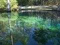 The springs
See also
References and external links
This article is issued from Wikipedia - version of the 11/19/2016. The text is available under the Creative Commons Attribution/Share Alike but additional terms may apply for the media files.