Waccasassa Bay Preserve State Park
| Waccasassa Bay Preserve State Park | |
|---|---|
|
IUCN category V (protected landscape/seascape) | |
 | |
| Location | Levy County, Florida, United States |
| Nearest city | Cedar Key, Florida |
| Coordinates | 29°20′44.37″N 82°55′50.31″W / 29.3456583°N 82.9306417°WCoordinates: 29°20′44.37″N 82°55′50.31″W / 29.3456583°N 82.9306417°W |
| Area | 30,784 acres (124.58 km2) |
| Governing body | Florida Department of Environmental Protection |
| Designated | December 1976 |
Waccasassa Bay Preserve State Park is a 30,784-acre (124.58 km2) salt marsh that stretches from Cedar Key and Yankee Town, and is only accessible by boat.
Some access points are from County Road 40 in Yankee Town, County Road 326 in Gulf Hammock, and Cedar Key.
It is the home to numerous species of saltwater fish and shellfish, as well as many endangered and threatened species, including manatees, alligators, bald eagles and black bears.
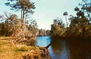
Salt marsh and woodlands at Waccasassa Bay.
Hours
Florida state parks are open between 8 a.m. and sundown every day of the year (including holidays).
External links
- Florida State Parks: official Waccasassa Bay Preserve State Park website
- Absolutely Florida: Waccasassa Bay Preserve State Park
| Wikimedia Commons has media related to Waccasassa Bay Preserve State Park. |
This article is issued from Wikipedia - version of the 11/18/2016. The text is available under the Creative Commons Attribution/Share Alike but additional terms may apply for the media files.