St. Marks National Wildlife Refuge
| St. Marks National Wildlife Refuge | |
|---|---|
|
IUCN category IV (habitat/species management area) | |
|
St. Marks National Wildlife Refuge shoreline near Lighthouse | |
 Map of the United States | |
| Location | Wakulla County, Jefferson County, Taylor County, Florida, United States |
| Nearest city | St. Marks, Florida |
| Coordinates | 30°07′00″N 84°15′00″W / 30.11667°N 84.25000°WCoordinates: 30°07′00″N 84°15′00″W / 30.11667°N 84.25000°W |
| Area | 68,000 acres (280 km2) |
| Established | 1931 |
| Governing body | U.S. Fish and Wildlife Service |
| Website | St. Marks National Wildlife Refuge |

St. Marks National Wildlife Refuge is one of the oldest wildlife refuges in the United States. Established in 1931 as a wintering ground for migratory birds, it encompasses 68,000 acres (280 km²) spread between Wakulla, Jefferson, and Taylor Counties in the state of Florida.
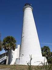
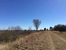
The refuge includes several Gulf of Mexico coastal habitats, such as saltwater marshes, islands, tidal creeks, and the estuaries of seven north Florida rivers. It is home to a diverse range of plant and animal life and also has a long history of human use, including structures such as the St. Marks Lighthouse, the second oldest lighthouse in Florida.
The refuge is a 'gateway site' for the Great Florida Birding Trail.
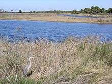
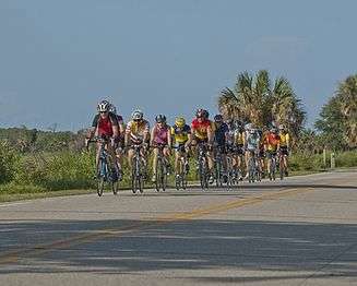
St. Marks National Wildlife Refuge offers many different attractions to outdoor enthusiasts. The refuge is inhabited by black bear, bobcat, otter, raccoon, fox, coyote, amphibians, alligator, snakes and many different species of birds including wading birds, shorebirds, waterfowl and raptors. During migrations, bird species and numbers dramatically increase. There are numerous fishing venues and many different freshwater and saltwater fish for fishing enthusiasts. A boat ramp near the lighthouse offers direct access to the St. Marks River and subsequently, the Gulf Of Mexico. The boat ramp is subject to tidal influence and low tides may affect launching and retrieving abilities. Kayakers have direct access to the Gulf from the Lighthouse parking lot. Hikers and cyclists have their choice of miles of impoundments and trails to traverse through widely varied habitats and ecosystems. There is a biking trail that runs about 20 miles from south side of Tallahassee all the way down to the refuge following alongside the railroad. The St. Marks NWR also offers a wide range of subjects and settings for artistic expression via sketching and drawing, painting and photography. The Refuge has a large Visitors Center with maps and brochures to help the visitors enjoy their trip. Inside the Visitors Center is a bookstore offering a wide variety of books and merchandise for sale. Next door to the Visitors Center is the Education building offering comfortable meeting facilities in one half of the building and facilities and staff devoted to education in the other half.
The Refuge attracts a very large volunteer base that assists the U.S. Fish and Wildlife Service by volunteering for research projects, outreach and public events such as educational field trips, festivals and historical celebrations. St. Marks NWR has a very successful friends group in the St. Marks Refuge Association and a very active Photography Club and the two organizations are prolific suppliers of volunteers for the Refuge.
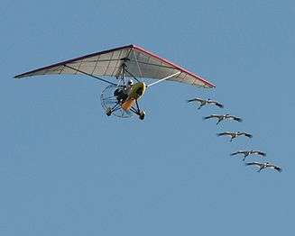
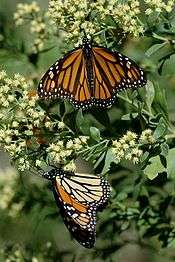
The St. Marks National Wildlife Refuge is home to one of the coveted wintering sites for the endangered Whooping Cranes that are led south by the ultra-light aircraft of Operation Migration. Operation Migration begins training Whooping Crane chicks with the aircraft shortly after birth and continue to the time of migration when they act as surrogate parents leading the birds south and imprinting their first annual migration. The Refuge is also a stopping point for the yearly Monarch butterfly migration. A festival is hosted annually around the time of the migration each October to educate people on the practice of tagging Monarchs as they continue through their migration.
The St. Marks National Wildlife Refuge also served as the inspiration for the setting of author Jeff VanderMeer's Southern Reach Trilogy.
|

Access
Public accesses to the refuge are located at:
- Panacea Unit
- Otter Lake, in Panacea
- Bottoms Road, in Panacea
- Skipper Bay Road, south of Medart (may be closed)
- Wakulla Unit
- Purify Bay Road, in Medart
- Shell Point Highway, north of Shell Point
- Wakulla Beach Road, east of Shell Point
- St. Marks Unit
- Lighthouse Road, the main entrance, in Newport
- Mandalay Bay Road, just east of the Aucilla River in Taylor County.
There is no paved public access to the refuge in Jefferson County.
External links
| Wikimedia Commons has media related to St. Marks National Wildlife Refuge. |
![]() This article incorporates public domain material from websites or documents of the United States Fish and Wildlife Service.
This article incorporates public domain material from websites or documents of the United States Fish and Wildlife Service.