J. N. "Ding" Darling National Wildlife Refuge
| J.N. 'Ding' Darling National Wildlife Refuge | |
|---|---|
|
IUCN category V (protected landscape/seascape) | |
 | |
 | |
| Location | Lee County, Florida, United States |
| Nearest city | Sanibel, Florida |
| Coordinates | 26°27′30″N 82°06′00″W / 26.45833°N 82.10000°WCoordinates: 26°27′30″N 82°06′00″W / 26.45833°N 82.10000°W |
| Area | 5200 acres (21 km2) |
| Established | 1976 |
| Governing body | US Fish & Wildlife Service |
| Website | J. N. "Ding" Darling National Wildlife Refuge |
The J. N. "Ding" Darling National Wildlife Refuge is part of the United States National Wildlife Refuge System, located in southwestern Florida, on Sanibel Island in the Gulf of Mexico. It is named for the cartoonist Jay Norwood "Ding" Darling.
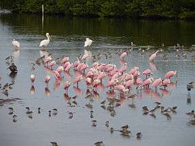
The 5200 acre (21 km2) refuge was established in 1976, to protect one of the country's largest undeveloped mangrove ecosystems. The refuge is well known for its migratory bird populations. Hurricane Charley struck the refuge on August 13, 2004, causing major changes to the topography and ecology. The J. N. "Ding" Darling National Wildlife Refuge Complex consists of the following: the Darling Refuge itself, and the Caloosahatchee, Island Bay, Matlacha, and Pine Island National Wildlife Refuges.
The northern section of the refuge is in the J.N. Ding Darling Wilderness Area, which was created in 1976 and currently protects 2,619 acres (1,060 ha) or 41% of the refuge.[1]
References
- ↑ "J.N. "Ding" Darling Wilderness". Wilderness.net. Retrieved 2011-08-22.
External links
 Media related to Ding Darling National Wildlife Refuge at Wikimedia Commons
- J.N. 'Ding' Darling National Wildlife Refuge at U.S. Fish and Wildlife Service
- 'Ding' Darling Wildlife Society
- J.N. 'Ding' Darling National Wildlife Refuge at J. N. 'Ding' Darling Foundation
- J.N. 'Ding' Darling National Wildlife Refuge at Florida Fish and Wildlife Conservation Commission
- J.N. 'Ding' Darling National Wildlife Refuge at Gorp.com