Port Elizabeth
| Port Elizabeth Die Baai (Afrikaans) iBhayi (Xhosa) | |
|---|---|
|
City Hall, Market Square, Port Elizabeth. | |
 Port Elizabeth  Port Elizabeth  Port Elizabeth
| |
| Coordinates: 33°57′29″S 25°36′00″E / 33.95806°S 25.60000°ECoordinates: 33°57′29″S 25°36′00″E / 33.95806°S 25.60000°E | |
| Country | South Africa |
| Province | Eastern Cape |
| Municipality | Nelson Mandela Bay |
| Established | 1820 |
| Government | |
| • Mayor | Athol Trollip (DA) |
| Area[1] | |
| • City | 251.03 km2 (96.92 sq mi) |
| • Metro | 1,959 km2 (756 sq mi) |
| Population (2011)[1] | |
| • City | 312,392 |
| • Density | 1,200/km2 (3,200/sq mi) |
| • Metro[1] | 1,152,915 |
| • Metro density | 590/km2 (1,500/sq mi) |
| Racial makeup (2011)[1] | |
| • Black African | 30.6% |
| • Coloured | 27.0% |
| • Indian/Asian | 3.2% |
| • White | 37.8% |
| • Other | 1.4% |
| First languages (2011)[1] | |
| • Afrikaans | 40.2% |
| • English | 33.2% |
| • Xhosa | 22.2% |
| • Other | 4.3% |
| Postal code (street) | 6001 |
| PO box | 6000 |
| Area code | 041 |

Port Elizabeth or The Bay[2] (Xhosa: iBhayi; Afrikaans: Die Baai [di bɑːi]) is one of the largest cities in South Africa, situated in the Eastern Cape Province, 770 km (478 mi) east of Cape Town. The city, often shortened to PE and nicknamed "The Friendly City" or "The Windy City", stretches for 16 km along Algoa Bay, and is one of the major seaports in South Africa. Port Elizabeth is the southernmost large city on the African continent, just farther south than Cape Town.
Port Elizabeth was founded as a town in 1820 to house British settlers as a way of strengthening the border region between the Cape Colony and the Xhosa. It now forms part of the Nelson Mandela Bay Metropolitan Municipality, which has a population of over 1.3 million.
History
The area around what is now called Algoa Bay was first settled by hunting and gathering people ancestral to the San at least 100,000 years ago. Around 2,000 years ago, they were gradually displaced or assimilated by agriculturalist populations ancestral to the Xhosa, who migrated into the region from the north.
The first Europeans to have visited the area were Portuguese explorers Bartholomeu Dias, who landed on St Croix Island in Algoa Bay in 1488,[3] and Vasco da Gama, who noted the nearby Bird Island in 1497. For centuries, the area was simply marked on European navigation charts as "a landing place with fresh water".[4]
One of the main goals of the Portuguese Crown in the Indian Ocean was to take over the lucrative trade of Arab and Afro-Arabian merchants who plied routes between the East African coast and India. As they took over that trade, the Portuguese strengthened trading with Goa, their colony in India. The name Algoa meant "to Goa," just as the port further north in present-day Mozambique, Delagoa meant "from Goa." Algoa was the port from which ships left for Goa during the season when the winds were favourable, while Delagoa was the port in Africa at which they arrived from Goa in the season when the winds for the return trip were favourable.
The area became part of the Cape Colony. This area had a turbulent history between its founding by the Dutch East India Company in 1652 and the formation of the Union of South Africa in 1910 as a result of the British winning the Boer War.
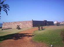
In 1799, during the first British occupation of the Colony during the Napoleonic Wars, a stone fort was built, named Fort Frederick after the Duke of York. This fort, built to protect against a possible landing of French troops, overlooked the site of what later became Port Elizabeth. It is now operated as a monument.[4]
From 1814 to 1821, the Strandfontein farm, which later became the Summerstrand beach suburb of Port Elizabeth, was owned by Piet Retief. He later became a Voortrekker leader and was killed in 1837 by Zulu king Dingane during negotiations about land. An estimated 500 men, woman and children of his party were massacred. After Retief, the Strandfontein farm was owned by Frederik Korsten. Another contemporary suburb of Port Elizabeth is named for him in the 21st century.
In 1820 a party of 4,000 British settlers arrived by sea, encouraged by the government of the Cape Colony to form a settlement to strengthen the border region between the Cape Colony and the Xhosa people. At this time the seaport town was founded by Sir Rufane Shaw Donkin, the Acting Governor of the Cape Colony, who named it after his late wife, Elizabeth. Diplomat Edmund Roberts visited Port Elizabeth in the early 1830s. He noted that Port Elizabeth in the 1820s had "contained four houses, and now it has upward of one hundred houses, and its residents are rated at above twelve hundred persons."[5]
The Apostolic Vicariate of Cape of Good Hope, Eastern District, was established in the city in 1847, and in 1861 Port Elizabeth was granted the status of autonomous municipality. The town expanded as a diverse community comprising European, Cape Malay and other immigrants. The population increased rapidly after 1873 when the railway to Kimberley was built. Prime Minister John Molteno had formed the Cape Government Railways in 1872, and the massive expansion of the Cape Colony's railway network over the following years saw the harbour of Port Elizabeth servicing a large area of the Cape's hinterland.[6][7]
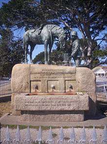
During the Second Boer War, the port was an important transit point for British soldiers, horses and materials headed to the front by railway. While no armed conflict took place within the city, many refugees from the war moved into the city. These included Boer women and children, who were interned by the British in a concentration camp. Following that war, the Horse Memorial was erected to honour the tens of thousands of horses and mules that died during the conflict.
Apartheid era
Under apartheid, the government established legal racial segregation and started programs to separate communities physically as well as by classification and custom. It forced relocation of the non-white population from mixed areas under the Group Areas Act began in 1962, causing various townships to be built for their use. The whole of the South End district, being a prime real estate location, was forcibly depopulated and flattened in 1965; relocations continued until 1975.[4] As black South Africans organized to try to achieve civil rights and social justice, government repression increased. In 1977 Steve Biko, the black anti-apartheid activist, was interrogated and tortured by the security police in PE, before being transported to Pretoria where he died.[8] Other notable deaths in the city during this time included the Cradock Four, and George Botha, a high school teacher.
Post-apartheid
The black majority finally achieved the vote. Since the multiracial elections of 1994, Port Elizabeth has faced the same problems as the rest of South Africa, more especially lack of foreign and government investment, coping with HIV/AIDS, and a general increase in crime.
With the establishment of the Coega Industrial Development Zone (CIDZ), foreign direct and also national level investment has improved substantially in the region of Nelson Mandela Bay/Port Elizabeth. The IDZ, under the stewardship of the Coega Development Corporation (CDC), since inception has managed to attract to its investment account in excess R140-billion into the Economy of the Eastern Cape and has enabled the creation of over 45 000 jobs. This is significant for the sustainability of the IDZ, Nelson Mandela Bay, and the economy of the Eastern Cape. The CDC consistently continues to demonstrate its capability as the leading catalyst for socio-economic growth in the Eastern Cape, with a view to becoming so for South Africa.
In 2001, the Nelson Mandela Bay Metropolitan Municipality was formed as an administrative area covering Port Elizabeth, the neighbouring towns of Uitenhage and Despatch and the surrounding agricultural areas. The name was chosen to honour former President Nelson Mandela. The combined metropolitan area had a population estimated at around 1.3 million in 2006.
2010 FIFA World Cup
The Port Elizabeth harbour, waterfront and city centre were upgraded for the 2010 FIFA World Cup, but do not rival the popular Cape Town waterfront. The 46,000-seat, R2 billion Nelson Mandela Bay Stadium was built in Port Elizabeth in time to serve as one of the venues for World Cup games. The stadium hosted eight World Cup games between 12 June 2010 and 10 July 2010.
Geography and climate
| Port Elizabeth | ||||||||||||||||||||||||||||||||||||||||||||||||||||||||||||
|---|---|---|---|---|---|---|---|---|---|---|---|---|---|---|---|---|---|---|---|---|---|---|---|---|---|---|---|---|---|---|---|---|---|---|---|---|---|---|---|---|---|---|---|---|---|---|---|---|---|---|---|---|---|---|---|---|---|---|---|---|
| Climate chart (explanation) | ||||||||||||||||||||||||||||||||||||||||||||||||||||||||||||
| ||||||||||||||||||||||||||||||||||||||||||||||||||||||||||||
| ||||||||||||||||||||||||||||||||||||||||||||||||||||||||||||
"The Windy City" has a subtropical climate with light rain throughout the year. Under the Köppen climate classification, Port Elizabeth has an oceanic climate (Cfb ). The area lies between the winter rainfall, Mediterranean climate zones of the Western Cape and the summer rainfall regions of eastern South Africa. Winters are cool but mild and summers are warm but considerably less humid and hot than more northerly parts of South Africa's east coast.[10] The climate is very even throughout the year with extreme heat or moderate cold rare. Three rivers flow through Port Elizabeth: the Chatty, the Shark, and the Baakens.
| Climate data for Port Elizabeth (1961−1990, extremes 1936–1990) | |||||||||||||
|---|---|---|---|---|---|---|---|---|---|---|---|---|---|
| Month | Jan | Feb | Mar | Apr | May | Jun | Jul | Aug | Sep | Oct | Nov | Dec | Year |
| Record high °C (°F) | 39.0 (102.2) |
40.0 (104) |
40.7 (105.3) |
39.0 (102.2) |
35.4 (95.7) |
32.4 (90.3) |
33.1 (91.6) |
36.8 (98.2) |
39.7 (103.5) |
39.8 (103.6) |
40.2 (104.4) |
36.0 (96.8) |
40.7 (105.3) |
| Average high °C (°F) | 25.4 (77.7) |
25.4 (77.7) |
24.6 (76.3) |
23.0 (73.4) |
21.7 (71.1) |
20.3 (68.5) |
19.7 (67.5) |
19.6 (67.3) |
20.0 (68) |
20.8 (69.4) |
22.3 (72.1) |
24.3 (75.7) |
22.3 (72.1) |
| Daily mean °C (°F) | 21.3 (70.3) |
21.2 (70.2) |
20.3 (68.5) |
18.2 (64.8) |
16.1 (61) |
14.3 (57.7) |
13.9 (57) |
14.3 (57.7) |
15.4 (59.7) |
16.7 (62.1) |
18.2 (64.8) |
20.1 (68.2) |
17.5 (63.5) |
| Average low °C (°F) | 17.9 (64.2) |
17.9 (64.2) |
16.9 (62.4) |
14.3 (57.7) |
11.5 (52.7) |
9.2 (48.6) |
8.8 (47.8) |
9.8 (49.6) |
11.4 (52.5) |
13.1 (55.6) |
14.6 (58.3) |
16.4 (61.5) |
13.5 (56.3) |
| Record low °C (°F) | 7.4 (45.3) |
7.9 (46.2) |
7.0 (44.6) |
4.4 (39.9) |
−0.3 (31.5) |
−0.5 (31.1) |
−0.5 (31.1) |
−0.2 (31.6) |
1.5 (34.7) |
3.0 (37.4) |
5.6 (42.1) |
6.5 (43.7) |
−0.5 (31.1) |
| Average precipitation mm (inches) | 36 (1.42) |
40 (1.57) |
54 (2.13) |
58 (2.28) |
59 (2.32) |
62 (2.44) |
47 (1.85) |
64 (2.52) |
62 (2.44) |
59 (2.32) |
49 (1.93) |
34 (1.34) |
624 (24.57) |
| Average precipitation days (≥ 1.0 mm) | 5 | 5 | 7 | 6 | 5 | 5 | 5 | 7 | 6 | 7 | 7 | 5 | 70 |
| Average relative humidity (%) | 77 | 80 | 81 | 80 | 76 | 73 | 74 | 76 | 77 | 78 | 78 | 77 | 77 |
| Mean monthly sunshine hours | 265.9 | 222.9 | 228.7 | 220.6 | 221.7 | 207.5 | 227.8 | 232.0 | 213.0 | 236.3 | 250.1 | 278.9 | 2,805.4 |
| Source #1: NOAA,[11] Deutscher Wetterdienst (extremes)[12] | |||||||||||||
| Source #2: South African Weather Service[9] | |||||||||||||
Demographics
|
<1 /km²
1–3 /km²
3–10 /km²
10–30 /km²
30–100 /km² |
100–300 /km²
300–1000 /km²
1000–3000 /km²
>3000 /km² |
In 2001:[13]
- Area: 335.3 square kilometres (129.5 sq mi)
- Population: 237,503: 708.32 inhabitants per square kilometre (1,834.5/sq mi)
- Households: 70,606: 210.58 per square kilometre (545.4/sq mi)
| Gender | Population | % |
|---|---|---|
| Female | 122,253 | 51.47 |
| Male | 115,247 | 48.53 |
| Race | Population | % |
|---|---|---|
| Black | 32,618 | 13.73 |
| White | 123,722 | 52.09 |
| Coloured | 71,912 | 30.28 |
| Asian | 9,248 | 3.89 |
| First language | Population | % |
|---|---|---|
| IsiZulu | 580 | 0.24 |
| IsiXhosa | 27,312 | 11.5 |
| Afrikaans | 112,798 | 47.49 |
| Sepedi | 90 | 0.04 |
| Setswana | 411 | 0.17 |
| English | 94,068 | 39.61 |
| Sesotho | 494 | 0.21 |
| Xitsonga | 107 | 0.05 |
| SiSwati | 75 | 0.03 |
| Tshivenda | 114 | 0.05 |
| IsiNdebele | 297 | 0.13 |
| Other | 1,152 | 0.49 |
| Historical population | ||
|---|---|---|
| Year | Pop. | ±% |
| 1985 | 272,844 | — |
| 1991 | 303,353 | +11.2% |
| 2001 | 237,503 | −21.7% |
| 2011 | 312,392 | +31.5% |
| [14] | ||
Economy
Trade and industry
Historically, the majority of trade in the region came through Port Elizabeth. In the 1830s, at least five ships regularly transported goods to Europe.[5] It became a free port in 1832.[15] In 1833, about 50 vessels had moved through the port. In 1828, 55,201 pounds of goods were imported through the port, increasing the following year to 12,845 pounds. Port Elizabeth exported 41,290 pounds in 1828, with a large increase to 86,931 goods exported in 1829. Exports included wine, brandy, vinegar, ivory, hides and skins, leather, tallow, butter, soap, wool, ostrich feathers, salted beef, wheat, candles, aloe, barley, and more.[5]
Home of South Africa's motor vehicle industry, Port Elizabeth boasts most vehicle assembly plants, General Motors, Ford, Continental Tyres and many more automotive companies. Most other industries in Port Elizabeth are geared towards the motor vehicle industry, providing parts such as wiring harnesses, catalytic converters, batteries and tyres to the vehicle manufacturers.
Port Elizabeth is also a major seaport, with the most significant ore loading facilities in the southern hemisphere. As part of the ongoing development, a new Industrial Development Zone with expanded port facilities has been built at Coega.
Tourism

Located at the end of the picturesque Garden Route along the Cape coast, the city has beaches in and near it. The most popular swimming beaches include King's Beach and Hobie Beach.
Many local historic attractions are linked by the Donkin Heritage Trail. These include the Campanile (bell tower), built in 1923 to commemorate the arrival of the 1820 Settlers and offering a viewpoint over the city; the city hall (1862); the Donkin Reserve park and monument; and the old stone Fort Frederick itself (1799). The CBD also boasts the towering Eastern Cape post office headquarters.
Route 67 is a walking trail consisting of 67 public artworks, symbolising 67 years which Nelson ‘Madiba’ Mandela dedicated to the freedom of South Africa. The artwork is a celebration of South African culture and history and is scattered along the route as it starts from the Campanile, up the stairs to the Vuysile Mini Market Square and to the large South African flag at the Donkin Reserve. The artworks were created by local Eastern Cape artists.[16]
Other attractions include the gardens at St George's Park, the Nelson Mandela Metropolitan Art Museum (formerly known as the King George VI Art Gallery), the museum and oceanography room at Humewood, and the new Boardwalk waterfront complex.
The wider area surrounding PE also features game viewing opportunities, including the Addo Elephant Park, 72 kilometres (45 mi) to the north near the Zuurberg mountain range and National Park.
Port Elizabeth is also a destination for whale watching with humpback whales sighted between June and August, and again between November and January, Southern right whales sighted between July and November, and Bryde's whales sighted all year round.
Sports

The city has facilities catering for cricket, rugby union, association football, field hockey and many other sports. Its coastal location also makes it a base for many watersports.
Port Elizabeth is the location of the St George's Park cricket ground, which holds test cricket matches. St George's Park is the oldest cricket ground in South Africa, and was the venue for the first Test match played outside of Australia or England, between South Africa and England on the 12 and 13 March 1889. The Warriors, a franchise cricket team in South Africa, is based in Port Elizabeth.
The headquarters of the Southern Spears rugby franchise was in Port Elizabeth. The long-standing Eastern Province Rugby Union, now commonly known as the Eastern Province Kings, formed the basis of the Spears franchise together with East London's Border Bulldogs. The remnants of the Spears were later reconstituted into the Southern Kings, also based in Port Elizabeth, which joined Super Rugby in 2013. The Southern Kings did not participate in Super Rugby in 2014 or 2015, but are due to make a reappearance in the 2016 version of the competition. The Eastern Province Rugby Union play their home matches at Nelson Mandela Bay Stadium, built for the 2010 FIFA World Cup.
In December 2011, Nelson Mandela Bay Stadium became the new home of the South Africa Sevens, the country's leg of the annual IRB Sevens World Series in rugby sevens. The event had previously been held in three other cities, most recently in George in the Western Cape from 2002 to 2010. As of 2015, the Sevens will be hosted in Cape Town, in the Western Cape.
The city's main football club is Chippa United, they currently use the Nelson Mandela Bay Stadium as their home ground. Previous clubs to play in the country's top tier were Bay United, Michau Warriors, Port Elizabeth Blackpool, Hotspur F.C., Port Elizabeth City and Westview Apollon.
The Algoa Bay Yacht Club operates out of the Port of Port Elizabeth.
Government
Port Elizabeth had its own municipality from 1843 to 2000. Since then, it has formed part of the Nelson Mandela Bay Metropolitan Municipality, and serves as the seat for the surrounding Cacadu District Municipality. It has a Magistrate's Court, a local seat of the Eastern Cape Division of the High Court, and a branch of the Labour Court. As a result of the presence of a High Court, several other related organs of state such as a Masters Office and a Director of Public Prosecutions are present in the city. All Government (mostly provincial) departments maintain branches or other offices in Port Elizabeth.
Coat of arms
The Port Elizabeth municipality assumed a coat of arms on 9 January 1878.[17] [18] The design, prepared by Bradbury Wilkinson and Company (of London), was a simplified version of the arms of Sir Rufane Donkin : Gules, on a chevron Argent between two cinquefoils in chief and a bugle horn stringed in base Or, three buckles Sable; a chief embattled Argent thereon an elephant statant proper. The crest was a sailing ship, and the motto In meliora spera.
(In layman's terms : a red shield displaying, from top to bottom, an elephant on a silver horizontal strip whose lower edge is embattled, two gold cinquefoils, a silver chevron bearing three black buckles, and a gold bugle horn.)
Eighty years later, in 1958, the council made slight changes to the arms, and had them granted by the College of Arms. The changes consisted of adding two anchors to the chief of the shield, placing a red mural crown bearing three golden rings below the ship in the crest, and changing the motto to Tu meliora spera. The arms were registered with the Cape Provincial Administration in 1959,[19] and at the Bureau of Heraldry in 1986.[20]
Education
The Nelson Mandela Metropolitan University (NMMU) was formed in 2005 by the amalgamation of the University of Port Elizabeth, Port Elizabeth Technikon, and the Port Elizabeth campus of Vista University. It is the largest university in the Eastern and Southern Cape, with around 24,000 students in seven faculties spread over five campuses.
The city has a number of top government-funded and private schools, including Alexander Road High School,[21] Collegiate Girls' High School, Victoria Park High School, Grey High School,[21][22] Pearson High School,[21] Woodridge College, Andrew Rabie High School and Lawson Brown High School.
Infrastructure
Transport
Roads
Port Elizabeth lies on the N2 road. To the west the road travels the Garden Route to George and Cape Town; to the east, the road runs through the so-called Border Country through Grahamstown, to East London then on to Durban, terminating in Ermelo in Mpumalanga. The R75 connects Port Elizabeth to the Karoo. The major routes within the city are numbered as metropolitan or M routes.
The city's main bus station is in Market Square. The public bus service is run by the Algoa Bus Company. Between 1881 and 1948, there was a Port Elizabeth tramway network, powered initially by horses, and later by electricity.
The city is in the process of building a bus rapid transit system which was intended for the 2010 FIFA world cup. this has been a massive failure as local taxi associations has prevented the implementation. the city has a lack of proper public transport and is lacking diversity which has had a negative impact on the poorer residents of the city who is dependent on public transport This has been suspended due to mismanagement which led to the project missing its May 2010 deadline. Calls for the project, which has left many parts of the city in a permanent state of construction have been made recently, and it is expected that the government will make a decision on the matter soon.
Railway
Port Elizabeth railway station is served by South Africa's rail network. Local commuter services are operated by Metrorail, while the Shosholoza Meyl long-distance passenger service links PE with Johannesburg via Bloemfontein where it is possible to connect with other long-distance routes.[23]
The Apple Express narrow-gauge tourist train to Avontuur operated from the separate station in Humewood Road near King's Beach. It departed regularly for Thornhill Village via Van Stadens River bridge, the highest narrow-gauge rail bridge in the world. The Apple Express was launched to provide a service to transport fresh produce and wood from the farms along the line to Avontuur. The line was completed in 1914 and the train delivered produce directly from the farms to ships in the Port Elizabeth Harbour. Service has now ceased.
In preparation for the 2010 World Cup Soccer event the Humerail Station was extensively upgraded. Several disused narrow gauge goods wagons were scrapped and removed from the site, several buildings in the area have also been renovated and revamped.
Due to modern transport methods and containerisation and refrigerated containers and trucks the Apple Express and its services became redundant.
Air
Port Elizabeth Airport (IATA airport code PLZ, ICAO airport code FAPE) serves the city for both passenger and cargo traffic. It is the fourth busiest airport in South Africa after Johannesburg International Airport, King Shaka International Airport in Durban, and Cape Town International Airport.
International visitors to the city must currently fly to either Johannesburg, Cape Town or Durban, and then take a domestic flight to Port Elizabeth. An upgrade to the terminal building, completed in 2004, created the necessary facilities to handle international flights[24] although none are scheduled as yet.
Sea
Port Elizabeth has a harbour in Algoa Bay, and the construction of an additional international harbour at Coega has supported an increase in the size of the city's industries and the addition of new industries.
Health care
The city has government-funded and private hospitals,[25] including:
- Aurora Rehabilitation Hospital
- Dora Nginza Hospital
- Elizabeth Donkin Hospital
- Empilweni Hospital
- Hunterscraig Private Hospital
- Jose Pearson TB Hospital
- Livingstone Hospital
- Mercantile Private Hospital
- Netcare Greenacres Hospital
- Nightingale Subacute Hospital
- Oasim Private Hospital
- Port Elizabeth Provincial Hospital
- St George's Hospital
- Westways Private Hospital
Notable people
- Johan Botha – cricketer
- Schalk Burger – rugby union player; 2004 IRB International Player of the Year
- Adrienne Camp – singer/songwriter
- Thinus Delport – rugby union player
- Gabriella Demetriades – model
- Athol Fugard - Playwright, novelist
- Danie Gerber – rugby union player
- Rodney Howard-Browne – Charismatic Christian evangelist in the US
- Danny Jordaan – 2010 FIFA world cup organising committee boss
- Len Killeen – rugby union player
- Zolani Mahola – actress and singer/songwriter with the band Freshlyground
- Shashi Naidoo – actress and TV anchor
- Zahied Mohamed - Information Systems
- Zim Ngqawana – jazz musician
- Wayne Parnell – cricketer
- Alviro Petersen – cricketer
- Robin Peterson – cricketer
- Shawn Phillips – singer/songwriter
- Graeme Pollock – cricketer
- Peter Pollock – cricketer
- Shaun Pollock – cricketer
- Ashwell Prince – cricketer
- Patrick Soon-Shiong – billionaire entrepreneur and philanthropist; part-owner of the LA Lakers; graduate of PE's Chinese High School
- Mzwandile Stick – rugby union player; former captain of the national sevens team; Backline coach for the South African Rugby Team
- Reeva Steenkamp – model
- Joe van Niekerk – rugby union player
- Siya Kolisi – Springbok Rugby Union Player
- Nikki Williams – singer/songwriter
- Russell Domingo - Proteas Cricket Coach
See also
- Red Location Museum
- List of heritage sites in Port Elizabeth
- Fort Frederick, Eastern Cape
- Bloemendal
External links
| Wikimedia Commons has media related to Port Elizabeth. |
| Wikivoyage has a travel guide for Port Elizabeth. |
| Wikisource has the text of the 1911 Encyclopædia Britannica article Port Elizabeth. |
References
- 1 2 3 4 5 "Main Place Port Elizabeth". Census 2011.
- ↑ Pettman, Charles (1913). Africanderisms; a glossary of South African colloquial words and phrases and of place and other names. Longmans, Green and Co. p. 51.
- ↑
 Chisholm, Hugh, ed. (1911). "Algoa Bay". Encyclopædia Britannica. 1 (11th ed.). Cambridge University Press. p. 655.
 - 1 2 3 "Nelson Mandela Bay Tourism – Historical information". Nelson Mandela Bay Tourism.
- 1 2 3 Roberts, Edmund (1837). Embassy to the Eastern Courts of Cochin-China, Siam, and Muscat. New York: Harper & Brothers. p. 388.
- ↑ Burman, Jose (1984). Early Railways at the Cape. Cape Town. Human & Rousseau, p.66. ISBN 0-7981-1760-5
- ↑ "Info Please article". Info Please.
- ↑ "Biography of Steve Biko". about.com African History.
- 1 2 "Climate data for Port Elizabeth". South African Weather Service. June 2011. Archived from the original on 4 March 2012. Retrieved 6 March 2010.
- ↑ "Rainfall". Falling Rain.
- ↑ "Port Elizabeth Climate Normals 1961−1990". National Oceanic and Atmospheric Administration. Retrieved March 16, 2015.
- ↑ "Klimatafel von Port Elizabeth (Flugh.), Prov. Eastern Cape / Südafrika" (PDF). Baseline climate means (1961-1990) from stations all over the world (in German). Deutscher Wetterdienst. Retrieved February 7, 2016.
- ↑ , Census 2001 – Main Place "Port Elizabeth"
- ↑ , Nelson Mandela Bay: Metropolitan Municipality & Main Places – Statistics & Maps on City Population
- ↑ Roberts, Edmund (1837). Embassy to the Eastern Courts of Cochin-China, Siam, and Muscat. New York: Harper & Brothers. p. 391.
- ↑ "67 Steps to take in Port Elizabeth". Umoya Cottages in Port Elizabeth.
- ↑ Western Cape Archives : Port Elizabeth Municipal Minutes (9 January 1878)
- ↑ Eastern Province Herald (11 January 1878)
- ↑ Cape of Good Hope Official Gazette 2969 (1 May 1959)
- ↑ National Archives of South Africa : Data of the Bureau of Heraldry
- 1 2 3 SA's Top Schools 17 Oct 2009
- ↑ "The 100 best high schools in Africa, 2003." Africa Almanac. Retrieved 21 November 2009.
- ↑ "Shosholoza Meyl". Spoornet.
- ↑ "Introduction and History of Port Elizabeth Airport". Airports Company of South Africa.
- ↑ List of hospitals in South Africa
Municipalities and communities of Nelson Mandela Bay Metropolitan Municipality, Eastern Cape | ||
|---|---|---|
District seat: Port Elizabeth | ||
| Cities and towns | .svg.png) | |