Portage la Prairie
| Portage la Prairie | ||
|---|---|---|
| City | ||
| City of Portage la Prairie | ||
|
Crescent lake, Portage la Prairie. | ||
| ||
| Nickname(s): Portage, P. la P., Plaptown | ||
| Motto: Progress | ||
 Portage la Prairie Location of Portage la Prairie in Manitoba | ||
| Coordinates: 49°58′22″N 98°17′31″W / 49.97278°N 98.29194°WCoordinates: 49°58′22″N 98°17′31″W / 49.97278°N 98.29194°W | ||
| Country | Canada | |
| Province | Manitoba | |
| Region | Central Plains | |
| Established | 1738 (Fort La Reine) | |
| Settled | 1851 (village) | |
| Incorporated |
1880 (town) 1907 (city) | |
| Government | ||
| • Type | Mayor–council government | |
| • Mayor | Irvine Ferris | |
| • City Council | Brent Budz, Liz Driedger, Melissa Draycott, Ryan Espey, Brent Froese, Wayne Wall | |
| • Member of Parliament (MP) | Candice Bergen | |
| • Member of Legislative Assembly (MLA) | Ian Wishart | |
| Area[1] | ||
| • Land | 24.67 km2 (9.53 sq mi) | |
| • Metro | 2,029.94 km2 (783.76 sq mi) | |
| Elevation[2] | 261 m (856 ft) | |
| Population (2011)[1] | ||
| • City | 12,996 (4th) | |
| • Density | 526.7/km2 (1,364/sq mi) | |
| • Metro | 20,494 ('06 Census) | |
| • Metro density | 10.1/km2 (26/sq mi) | |
| Time zone | Central Time zone (UTC-6) | |
| Area code(s) | 204 | |
| Website | www.city.portage-la-prairie.mb.ca | |
.JPG)

Portage la Prairie /ˈpɔːrtᵻdʒ lə ˈprɛərɪ/ is a small city in the Central Plains Region of Manitoba, Canada. As of 2011, the population was 12,996 and the land area of the city was 24.67 square kilometres (9.53 sq mi).[1] Portage la Prairie is located approximately 75 kilometres (47 mi) west of Winnipeg, along the Trans-Canada Highway (located exactly between the provincial boundaries of Saskatchewan and Ontario), and sits on the Assiniboine River, which flooded the town persistently until a diversion channel north to Lake Manitoba (the Portage Diversion) was built to divert the flood waters. The city is surrounded by the Rural Municipality of Portage la Prairie.
According to Environment Canada, Portage la Prairie has the most sunny days during the warm months in Canada.[3]
It is the administrative headquarters of the Dakota Tipi First Nations reserve.
History
The area was most likely inhabited by Aboriginals, or First Nations, before European settlers began to arrive prior to 1850. In September 1738, after the fur trade had extended into Western Canada. Pierre Gaultier de Varennes, sieur de La Vérendrye (a French Canadian explorer and fur trader) built Fort La Reine north of the Assiniboine River to serve as a fur trading post, and provide the explorers with a "home" operating base, from which they would explore other parts of central Manitoba and western North America.
In 1851, Archdeacon William Cochrane (Cockran)[4] of the Anglican Church, John McLean,[5] as well as other ambitious settlers, were among the first to purchase the first land in the area from the local Aboriginals, around what is now Crescent Lake (formerly known as "The Slough"). A school was soon built as settlers poured in from the east, followed by a church (St. Mary's La Prairie, 1854), and numerous local businesses as the community began to form. The fertile soils of the Portage la Prairie area were discovered in the 1850s, giving birth to the future agriculturally based economy of the village; Archdeacon Cochrane encouraged people to start growing crops and gardens on their properties to fulfill the needs of the growing food demand. A local government was formed in 1857, and by the 1860s, there were sixty homes situated in the community.
The 1870s was a decade of rapid growth, as many more settlers moved to Portage, establishing farms and opening new businesses. By this time, the village had an operating flour mill, a local newspaper, and a community fair; just to name a few of Portage's highlights. From the 1870s to the 1880s, the community increased in population by approximately 10 times (300-3,000). Freight and supplies were transported by ox-cart and steamboat until the arrival of the Canadian Pacific Railway (CPR) in 1881, the year Portage was incorporated as a town. Thomas Collins was the first mayor of Portage la Prairie.
In 1907, Portage was incorporated as a city, and from that point on, managed to keep a gradual rate of growth and development, serving as a regional hub for agriculture, retail, manufacturing and transportation in central Manitoba.
During WWII, the Royal Canadian Air Force constructed Canadian Forces Base Portage la Prairie in support of the British Commonwealth Air Training Plan. The station was controlled by the RCAF but used naval personnel as high-frequency direction finding operators. The station's priority was German U-boat traffic. This site and CFB Rivers located at Rivers, Manitoba helped to increase the fix accuracy immensely.
The name is derived from the French word portage, which means to carry a canoe overland between waterways. In this case the "portage" was between the Assiniboine River and Lake Manitoba, over la prairie.
Topography
The city became a major transportation centre due to its proximity to the river, and later, the location of the main lines of the country's national railways passing through the community. Both the CPR and Canadian National Railways (CNR) intersect in Portage; one of the few places in Canada where the two railways meet. This has made Portage la Prairie one of the most ideal places for railway aficionados to view trains; approximately 72 trains pass through the city each day. The Trans-Canada Highway, a major national transportation route, runs past the city and provides the community with business if highway travellers decide to make a trek into Portage. Also, since the land is very fertile, with soils abundant in nutrients, Portage la Prairie is a major agricultural centre in Manitoba, as well as Canada. The rural area surrounding the community is undoubtedly a breadbasket in Canada, having some of the best soils in the country for producing a wide array of vegetables, berries, grains and lentils.
The city has an aggressive tree planting program and is known for its mature urban forest. A collection of some of the largest cottonwood trees in Canada line the west end of the main street known as Saskatchewan Avenue (as well as Crescent Road which runs adjacent to Crescent Lake), and, along with many other varieties, are present throughout the city.
It is also the home of former Prime Minister of Canada Arthur Meighen; a school and an avenue are named in his honour.
Climate
According to Environment Canada, Portage la Prairie has the most sunny days during the warm months in Canada.[3] Portage has a humid continental climate (Köppen climate classification Dfb, United States Department of Agriculture, Plant Hardiness Zone 3a[6]) with warm summers and cold, dry winters. The highest temperature ever recorded in Portage La Prairie was 41.1 °C (106 °F) on 11 July 1936.[7] The coldest temperature ever recorded was −44.0 °C (−47.2 °F) on 2 February 1996.[2]
| Climate data for Portage la Prairie, 1981–2010 normals, extremes 1886–present[lower-alpha 1] | |||||||||||||
|---|---|---|---|---|---|---|---|---|---|---|---|---|---|
| Month | Jan | Feb | Mar | Apr | May | Jun | Jul | Aug | Sep | Oct | Nov | Dec | Year |
| Record high °C (°F) | 10.3 (50.5) |
14.4 (57.9) |
25.0 (77) |
35.0 (95) |
37.5 (99.5) |
38.9 (102) |
41.1 (106) |
40.0 (104) |
40.0 (104) |
32.8 (91) |
22.8 (73) |
12.8 (55) |
41.1 (106) |
| Average high °C (°F) | −10.6 (12.9) |
−7.2 (19) |
−0.7 (30.7) |
9.9 (49.8) |
18.8 (65.8) |
23.2 (73.8) |
25.4 (77.7) |
25.0 (77) |
18.3 (64.9) |
10.5 (50.9) |
−0.8 (30.6) |
−9.0 (15.8) |
8.6 (47.5) |
| Daily mean °C (°F) | −16.0 (3.2) |
−12.7 (9.1) |
−5.7 (21.7) |
3.7 (38.7) |
11.6 (52.9) |
17.0 (62.6) |
19.2 (66.6) |
18.4 (65.1) |
12.1 (53.8) |
5.1 (41.2) |
−5.1 (22.8) |
−13.8 (7.2) |
2.8 (37) |
| Average low °C (°F) | −21.4 (−6.5) |
−18.2 (−0.8) |
−10.7 (12.7) |
−2.5 (27.5) |
4.4 (39.9) |
10.7 (51.3) |
13.0 (55.4) |
11.6 (52.9) |
5.8 (42.4) |
−0.3 (31.5) |
−9.5 (14.9) |
−18.5 (−1.3) |
−3.0 (26.6) |
| Record low °C (°F) | −42.0 (−43.6) |
−44.0 (−47.2) |
−37.8 (−36) |
−25.6 (−14.1) |
−12.8 (9) |
−3.9 (25) |
0.0 (32) |
−1.7 (28.9) |
−7.2 (19) |
−21.1 (−6) |
−36.0 (−32.8) |
−39.0 (−38.2) |
−44.0 (−47.2) |
| Average precipitation mm (inches) | 22.6 (0.89) |
14.9 (0.587) |
26.2 (1.031) |
25.4 (1) |
42.9 (1.689) |
82.4 (3.244) |
80.0 (3.15) |
74.0 (2.913) |
57.0 (2.244) |
45.8 (1.803) |
28.9 (1.138) |
26.5 (1.043) |
526.5 (20.728) |
| Average rainfall mm (inches) | 0.3 (0.012) |
0.1 (0.004) |
10.0 (0.394) |
16.0 (0.63) |
40.7 (1.602) |
82.4 (3.244) |
80.0 (3.15) |
74.0 (2.913) |
56.3 (2.217) |
38.8 (1.528) |
6.8 (0.268) |
2.0 (0.079) |
407.4 (16.039) |
| Average snowfall cm (inches) | 22.3 (8.78) |
14.8 (5.83) |
16.2 (6.38) |
9.4 (3.7) |
2.2 (0.87) |
0.0 (0) |
0.0 (0) |
0.0 (0) |
0.7 (0.28) |
6.9 (2.72) |
22.1 (8.7) |
24.5 (9.65) |
119.1 (46.89) |
| Average precipitation days (≥ 0.2 mm) | 9.5 | 5.4 | 5.6 | 5.4 | 8.6 | 10.7 | 10.6 | 9.1 | 9.2 | 8.5 | 6.3 | 8.8 | 97.7 |
| Average rainy days (≥ 0.2 mm) | 0.1 | 0.1 | 1.7 | 3.7 | 8.3 | 10.7 | 10.6 | 9.1 | 9.1 | 7.2 | 1.6 | 0.3 | 62.5 |
| Average snowy days (≥ 0.2 cm) | 9.7 | 5.3 | 4.4 | 2.1 | 0.4 | 0.0 | 0.0 | 0.0 | 0.2 | 1.6 | 4.9 | 8.5 | 37.2 |
| Source: Environment Canada[2][7][8][9][10] | |||||||||||||
| Climate data for Southport Airport, 1981–2010 normals, extremes 1941–1992[lower-alpha 2] | |||||||||||||
|---|---|---|---|---|---|---|---|---|---|---|---|---|---|
| Month | Jan | Feb | Mar | Apr | May | Jun | Jul | Aug | Sep | Oct | Nov | Dec | Year |
| Record high humidex | 8.1 | 11.7 | 18.9 | 34.3 | 40.6 | 49.3 | 49.7 | 46.8 | 44.1 | 31.7 | 22.8 | 12.8 | 49.7 |
| Record high °C (°F) | 11.1 (52) |
12.2 (54) |
19.4 (66.9) |
34.8 (94.6) |
37.8 (100) |
37.3 (99.1) |
37.2 (99) |
40.2 (104.4) |
37.8 (100) |
30.0 (86) |
22.8 (73) |
13.9 (57) |
40.2 (104.4) |
| Average high °C (°F) | −9.0 (15.8) |
−6.2 (20.8) |
0.3 (32.5) |
11.1 (52) |
19.4 (66.9) |
23.3 (73.9) |
26.5 (79.7) |
25.9 (78.6) |
18.5 (65.3) |
10.7 (51.3) |
−0.5 (31.1) |
−8.6 (16.5) |
9.3 (48.7) |
| Daily mean °C (°F) | −14.3 (6.3) |
−11.3 (11.7) |
−4.6 (23.7) |
4.8 (40.6) |
12.4 (54.3) |
17.1 (62.8) |
20.3 (68.5) |
19.2 (66.6) |
12.4 (54.3) |
5.2 (41.4) |
−4.9 (23.2) |
−13.3 (8.1) |
3.6 (38.5) |
| Average low °C (°F) | −19.6 (−3.3) |
−16.5 (2.3) |
−9.5 (14.9) |
−1.5 (29.3) |
5.3 (41.5) |
10.7 (51.3) |
14.0 (57.2) |
12.5 (54.5) |
6.4 (43.5) |
−0.3 (31.5) |
−9.3 (15.3) |
−17.9 (−0.2) |
−2.2 (28) |
| Record low °C (°F) | −41.1 (−42) |
−42.2 (−44) |
−34.4 (−29.9) |
−23.3 (−9.9) |
−12.8 (9) |
−1.7 (28.9) |
2.2 (36) |
0.6 (33.1) |
−6.7 (19.9) |
−20.1 (−4.2) |
−34.5 (−30.1) |
−37.2 (−35) |
−42.2 (−44) |
| Record low wind chill | −54.0 | −54.6 | −48.2 | −31.7 | −19.3 | −5.1 | 0.0 | 0.0 | −10.8 | −27.2 | −43.1 | −52.1 | −54.6 |
| Average precipitation mm (inches) | 17.7 (0.697) |
13.5 (0.531) |
25.3 (0.996) |
29.4 (1.157) |
44.5 (1.752) |
82.9 (3.264) |
76.6 (3.016) |
64.4 (2.535) |
59.4 (2.339) |
44.4 (1.748) |
21.5 (0.846) |
20.4 (0.803) |
500.0 (19.685) |
| Average rainfall mm (inches) | 0.5 (0.02) |
0.3 (0.012) |
8.7 (0.343) |
18.4 (0.724) |
41.3 (1.626) |
82.9 (3.264) |
76.6 (3.016) |
64.4 (2.535) |
57.2 (2.252) |
34.4 (1.354) |
6.5 (0.256) |
3.2 (0.126) |
394.3 (15.524) |
| Average snowfall cm (inches) | 28.0 (11.02) |
20.0 (7.87) |
20.0 (7.87) |
13.0 (5.12) |
3.2 (1.26) |
0.0 (0) |
0.0 (0) |
0.0 (0) |
2.2 (0.87) |
12.8 (5.04) |
22.3 (8.78) |
27.8 (10.94) |
149.3 (58.78) |
| Average precipitation days (≥ 0.2 mm) | 11.3 | 7.3 | 8.3 | 7.0 | 10.1 | 13.7 | 11.9 | 10.6 | 11.4 | 11.5 | 8.9 | 10.0 | 122.0 |
| Average rainy days (≥ 0.2 mm) | 0.8 | 0.3 | 2.8 | 5.0 | 9.7 | 13.7 | 11.9 | 10.6 | 11.1 | 9.0 | 2.7 | 0.7 | 78.4 |
| Average snowy days (≥ 0.2 cm) | 12.1 | 8.6 | 7.0 | 2.9 | 0.8 | 0.0 | 0.0 | 0.0 | 0.5 | 3.7 | 7.1 | 11.0 | 53.7 |
| Average relative humidity (%) | 69.7 | 68.2 | 65.6 | 48.7 | 44.4 | 50.5 | 52.2 | 48.3 | 52.5 | 56.3 | 67.3 | 69.7 | 57.8 |
| Source: Environment Canada[2] | |||||||||||||
| Climate data for Portage la Prairie CDA[lower-alpha 3] | |||||||||||||
|---|---|---|---|---|---|---|---|---|---|---|---|---|---|
| Month | Jan | Feb | Mar | Apr | May | Jun | Jul | Aug | Sep | Oct | Nov | Dec | Year |
| Average precipitation mm (inches) | 21.3 (0.839) |
16.2 (0.638) |
25.7 (1.012) |
28.3 (1.114) |
58.4 (2.299) |
90.0 (3.543) |
78.4 (3.087) |
68.3 (2.689) |
50.1 (1.972) |
43.2 (1.701) |
25.8 (1.016) |
26.8 (1.055) |
532.4 (20.961) |
| Average rainfall mm (inches) | 0.7 (0.028) |
1.7 (0.067) |
11.1 (0.437) |
17.6 (0.693) |
54.4 (2.142) |
90.0 (3.543) |
78.4 (3.087) |
68.3 (2.689) |
49.8 (1.961) |
35.5 (1.398) |
6.7 (0.264) |
1.5 (0.059) |
415.6 (16.362) |
| Average snowfall cm (inches) | 21.5 (8.46) |
14.9 (5.87) |
14.9 (5.87) |
10.8 (4.25) |
4.0 (1.57) |
0.0 (0) |
0.0 (0) |
0.0 (0) |
0.3 (0.12) |
7.7 (3.03) |
19.1 (7.52) |
25.3 (9.96) |
118.5 (46.65) |
| Average precipitation days (≥ 0.2 mm) | 7.9 | 5.8 | 6.3 | 5.1 | 8.6 | 11.4 | 9.1 | 8.9 | 8.7 | 7.2 | 6.3 | 7.5 | 92.8 |
| Average rainy days (≥ 0.2 mm) | 0.3 | 0.7 | 2.0 | 3.4 | 8.2 | 11.4 | 9.1 | 8.9 | 8.6 | 5.7 | 1.5 | 0.5 | 60.2 |
| Average snowy days (≥ 0.2 cm) | 7.7 | 5.4 | 4.7 | 2.0 | 0.6 | 0.0 | 0.0 | 0.0 | 0.1 | 1.7 | 5.1 | 7.2 | 34.4 |
| Source: Environment Canada Canadian Climate Normals 1981–2010[2] | |||||||||||||
Demographics
| Historical populations | ||
|---|---|---|
| Year | Pop. | ±% |
| 1891 | 3,363 | — |
| 1901 | 3,901 | +16.0% |
| 1911 | 5,892 | +51.0% |
| 1921 | 6,766 | +14.8% |
| 1931 | 6,597 | −2.5% |
| 1941 | 7,095 | +7.5% |
| 1951 | 8,511 | +20.0% |
| 1961 | 12,388 | +45.6% |
| 1971 | 12,950 | +4.5% |
| 1981 | 13,086 | +1.1% |
| 1991 | 13,186 | +0.8% |
| 2001 | 12,976 | −1.6% |
| 2006 | 12,728 | −1.9% |
| 2011 | 12,996 | +2.1% |
According to the 2011 Census, Portage la Prairie was home to 12,996 people, which was a 2.1% increase from the prior census in 2006. The land area of Portage la Prairie is 24.67 km2 (9.53 sq mi), making the population density of 526.7/km2 (1,364/sq mi). There are 5,649 private dwellings in the city, 5,391 which are occupied (95.4% occupancy rate). The median value of a dwelling is $150,297 in Portage la Prairie, almost half as low as the national median at $280,552. The average household has 2.3 people and the average family has 1.1 children. The median (after-tax) household income in the area is $46,963, lower than the national rate at $54,089. The median age of Portage la Prairie is 40.8, essentially par with the national median at 40.6 years old.[1][12]
The census also reports that 89.9% of the residents' mother tongue was English, followed by French (2.5%) and German (2.5%).
Portage la Prairie is mostly inhabited by Aboriginal and White people (97.2%). The racial make up is as followed:
- 74.2% White
- 23.0% Aboriginal; 10.5% First Nations, 12.1% Metis
- 1.1% Southeast Asian; 1.1% Filipino
- 0.6% South Asian
- 0.5% Black
- 0.3% Latin American
- 0.1% Arab
- 0.0% Multiracial; 12.1% including Metis
Religiously speaking, most of the residents either practice a form of Christianity (66.4%) or have no religious affiliation at all (30.9%). 1.7% of the population practice a form of traditional Aboriginal spirituality.
Education
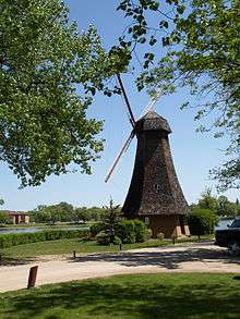
.JPG)
Public education falls under the Portage la Prairie School Division.[13]
Public schools
- École Arthur Meighen School
- École Crescentview School
- Fort la Reine School
- Hutterian Schools
- La Verendrye School
- North Memorial School
- Oakville School
- Portage Collegiate Institute
- Yellowquill School
Private schools
- Westpark School[14]
- Solid Rock Ministries Christian School
Post-secondary schools
- Portage Campus of the Red River College[15]
Other
Portage Learning & Literacy Centre[16]
Transportation
Portage la Prairie railway station is served by Via Rail with both the Canadian and Winnipeg – Churchill trains calling at the station.
The Portage la Prairie Canadian Pacific Railway Station no longer receives passenger rail service, and is operated as a museum.
The Portage la Prairie Southport Airport is a former air force base and the primary airport in the city. The Portage la Prairie (North) Airport is also located near Portage la Prairie and consists of a grass field.
Local media

- Newspapers
- Weekly newspaper, The Daily Graphic
- Weekly newspaper, Herald Leader Press.
- The Winnipeg Free Press and Winnipeg Sun are also available.
- Radio
- CFRY (AM) 920 - country music, owned by Golden West Broadcasting
- CHPO-FM 93.1 -country music, owned by Golden West Broadcasting
- CJPG-FM 96.5 - classic hits, owned by Golden West Broadcasting
- Television
Portage la Prairie receives all television stations from nearby Winnipeg. CHMI-DT channel 13, affiliated with Citytv, is licensed to Portage la Prairie, with studios in downtown Winnipeg.
Cable television is also available through MTS Ultimate TV and Shaw Cable systems.
Culture
Scenes for the documentary film We Were Children were shot at the former residential school in Portage la Prairie, now the Rufus Prince building.[17]
The punk rock band Propagandhi was formed in the city in 1986 by guitarist Chris Hannah and drummer Jord Samolesky.
Parks
In central Portage la Prairie, there is a peninsula known as Island Park, bounded by an oxbow lake called Crescent Lake (however, an extensive marsh located at the south ends of the lake connects the two halves of Crescent Lake, as a creek runs from one end to the other, but since two land bridges cross the oxbow, the island is no longer an official "island"). Every winter, the "island" has a festival of lights consisting of Christmas lights decorating a driving path around the perimeter. In addition, a highly popular winter lights parade is held. The island has an 18-hole golf course, Portage Industrial Exhibition grounds which hosts various agricultural competitions and midway, an outdoor water park, a large pen enclosure for deer, a birdcage area featuring peacocks, playgrounds, walking trails, tennis courts, a duck pond, various monuments, and an extensive arboretum. It is also the site of the new Portage Credit Union Centre; the new home of the Portage Terriers hockey club and an indoor water park. As well, Crescent Lake is home to flocks of migrating and nesting Canada geese.
Just south of the Portage la Prairie by-pass is the Portage Spillway, where the Assiniboine River empties into a diversion which in recent years has protected the city from flooding. Not only does this area mark the importance of the river in Portage's history, but it is home to Portage Spillway-Wayside Provincial Park, a park that is especially popular with fishermen in the summer months. Also not far southwest lies Spruce Woods Provincial Park and not far north lies St. Ambroise Beach Provincial Park. The city is also home to a network of multi-use recreational trails running through the parks and forested areas, which provide an oasis for sightseers to view wildlife. Geocaching has become popular in these areas, as people are finding more innovative ways to get out hiking in this scenic urban forest.
Aside from parks, the Portage la Prairie/Central Plains Region features many fine campgrounds located within a 15-30 minute drive of the city, and offers a few public beaches including Delta Beach, home to the Delta Marsh Field Station/Wildlife Reserve (part of this beach/area has been destroyed due to recent flooding in the spring of 2011), Jackson Lake (located 2 mi (3.2 km) southeast of Sidney, Manitoba, about a 35-minute drive west of Portage la Prairie) and Twin Lakes Beach, located an hour northeast of Portage, also on Lake Manitoba.
Attractions
.JPG)
One of Portage la Prairie's most popular attractions, the Community Walkway, which parallels Crescent Lake, is a 5.2 km (3.2 mi), multi-use trail used for walking, bicycling, skateboarding and rollerblading, running past many grand heritage homes and the tranquil, picturesque sites along the lake.
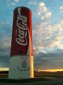
Other attractions include the world's largest Coca-Cola can. It was constructed from an old water tower and is now located between the local Canadian Tire and Canad Inns hotel on Saskatchewan Avenue West.
Portage la Prairie is considered to be the world strawberry capital and the North American potato processing capital. Many U-pick strawberry and Saskatoon berry farms are within a 15-minute drive by car.
Heritage Square is an outdoor community meeting place (particularly in the summer months), located downtown. Surrounding Heritage Square are the Cinema Centre, Portage la Prairie Regional Library,[18] and the William Glesby Centre—a performing arts facility which offers a live theatre & community art gallery. The William Glesby Centre is considered to be the cultural gathering place of Portage, and is used for many local events and live venues.
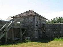
The Portage Credit Union Centre opened in February 2010 and features two National Hockey League regulation size indoor arenas, one with seating capacity for 1,680, as well as an indoor pool and wave pool, it is also home to the farmers market. Fort La Reine Museum is a museum located on the east end of Portage. The original Fort la Reine was built in 1738 by the French explorer Pierre Gaultier de Varennes, sieur de La Vérendrye and served as his headquarters for 15 years. Today the museum is home to an array of buildings from Portage and the surrounding region, and covers local prairie history from the 18th century (the period of French exploration) to the present day. Currently there are 25 buildings open to the public, each containing hundreds of artifacts, on display. Some of the highlights of the museum are a railway caboose and the 1882 official rail car of Sir William Cornelius Van Horne, builder of the Canadian Pacific Railway; a fully restored Ukrainian Pioneer Church; a number of houses that are more than 100 years old; a replica of Fort la Reine; a firehall with a fully restored 1931 Seagrave Fire Truck; the Old Officers Mess from the now retired Canadian Forces Base in Southport; and a school house and church built in the 1880s from West Prospect (a pioneer farming community that no longer exists).
The Manitoba Softball Hall of Fame/Museum is dedicated to the history of softball in Manitoba. It has memorabilia from the 1930s to the present. It is housed in the Fort la Reine Museum in a former barracks, moved from nearby Canadian Forces Base Southport.
Portage la Prairie's City Hall is a limestone structure that was designed by Thomas Fuller, who also designed the Parliament Buildings in Ottawa. It was opened in 1898 as a Dominion Post Office and became City Hall in 1960. The building was declared a historical site in 1986. On the roof is a bell which tolls for a few seconds daily at 9 am, noon, 3 pm, 6 pm and 9 pm.
Aside from City Hall, the city is home to many other heritage buildings. St. Mary's la Prairie Anglican Church, built in 1854, is located near the downtown. Saskatchewan Avenue (the city's main thoroughfare) contains many historical buildings, as well as Tupper Street and Royal Road (named after the Royal Visit of Queen Elizabeth The Queen Mother and King George VI in 1939). Crescent Road, which follows Crescent Lake for over 5 km, is lined with many large, grand heritage homes dating back to the late 19th century and early 20th century.
Portage's largest hotel, part of Canad-Inns, is located in the west end of the city. This hotel includes the rink of the Portage Curling Club, Aalto's Garden Cafe, a pub known as Tavern United, and many banquet halls.
There are several events held annually in Portage la Prairie, which include the Manitoba Hydro Power Smart Island of Lights running from November through January, the Portage Exhibition & Fair ("PortageX") held every July, the Portage Potato Festival which takes place in August,[19] and Canadian Forces Day in early June at Southport.
The community of Southport, located about 5 km (3.1 mi) south of Portage la Prairie, is home to a small recreation complex featuring a gymnasium and 5-pin bowling alley, aside from the proudly displayed military/air force history throughout the town and airport.
Military
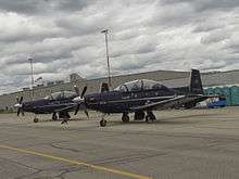
Portage la Prairie had a military airbase south of the community known as Canadian Forces Base Portage la Prairie, now 3 Canadian Forces Flying Training School. It was established as part of the British Commonwealth Air Training Plan during the Second World War and trained thousands of pilots for military service from around the world.
In 1990, the federal government transferred the assets of the property to Southport Aerospace Centre Inc., a not-for-profit property management and development company whose goal was to successfully manage the site.
The 13th Field Battery of the 26th Field Artillery Regiment, Royal Canadian Artillery is based out of Portage la Prairie.
During the Second World War an Algerine-class minesweeper commissioned into the Royal Canadian Navy was named after Portage la Prairie. The Portage was active during the war as an escort and afterwards as a training vessel.[20] As part of the 100th Anniversary of the Royal Canadian Navy, in 2010, the Navy provided the city with a display on the ship that is currently located in City Hall.
Economy

The local economy is largely dependent on agriculture and supporting industries (trucking, transportation, chemical/fertilizer, farm machinery dealerships, etc.). Portage la Prairie is also home to the McCain Foods and Simplot potato processing plants, which provide French fries for McDonald's, Wendy's, and various other commercialized restaurant chains. Viterra, owned by Glencore Xstrata and previously known as Can-oat milling, one of the largest oat mills in the world, is also located in the municipality. McMillan Industrial Park, located on the eastern fringes of Portage, also plays a major role in the city's economy. Numerous industries including food science labs and food processing facilities, construction companies, and manufacturing sectors are located in this expanding industrial area, beneficial for the creation of jobs in the community.
The city has developed into a regional retail service center as large big box style stores began to operate on the west end of the city in 2007. The west end will continue to see future development with new retail outlets lined up.[21] Many small towns and Native reserves use this as their primary shopping destination. Since Portage la Prairie is a commercial hub for the Central Plains Area, it serves some 50,000 people living within an approximately 50 km radius.
Portage la Prairie is a farming city, with an average of 122 frost free days,[2] and a USDA Plant Hardiness Zone of 3a.[6] Agriculture is the city's main industry.
Government
The city is governed by a mayor and six councillors. As of November 2015, the mayor is Irvine Ferris.[22]
Ian Wishart, Progressive Conservative Party of Manitoba, was elected to the Legislative Assembly of Manitoba in the 2011 general election in the Portage la Prairie provincial electoral district.[23]
Conservative Party member Candice Bergen (politician) was elected to the Parliament of Canada for the Portage—Lisgar riding in both the 2008 and 2011 federal elections.[24]
City issues
Various new residential developments and an upsurge in renovating older homes is contributing to the improvement of housing stock in the community. All of these new housing developments are occurring on the south side of the town, on or near Crescent Lake and Garrioch Creek.
Flooding also poses an occasional problem in the rural area of Portage la Prairie, especially during the spring.
In 2010 MoneySense as part of MSN's news site rated Portage la Prairie in a tie for Canada's worst city to live in, with relation to population decline,[25] but at the same time was ranked the 69th, out of 180 cities, best place to live in Canada.[26] However, according to the 2012 MoneySense statistics, a series of polls in a number of different areas that relate to the benefits of living in a city, rated Portage la Prairie as the 49th best city, up from 60th in 2011,[26] to live in overall (out of 190 Canadian communities), in Canada, and the 8th best in its population group. This is due to recent community revitalization programs and measures that have been taken to promote growth and industry, safety, culture, infrastructure, etc., which have significantly contributed to the growth, prosperity and strengthening economy of the community.[27]
Sports
Portage la Prairie is home to the Portage Terriers, who play in the Manitoba Junior Hockey League, and the Central Plains Capitals, who play in the Manitoba Midget 'AAA' and Manitoba Female Midget Hockey Leagues. In the 2014/2015 season, the Portage Terriers had a regular season record of 53 wins, 4 losses and 3 ties and had the best hockey record/winning percentage in the world. In that season, they also won the Turnbull Cup as champions of the Manitoba Junior Hockey League and hosted the RBC Cup for the National Junior A Championship, which they also won.
The Portage Credit Union Centre is the city's main recreation facility and houses two arenas, an aquatic centre, a fitness centre, and indoor walking track. Outdoor sports facilities are located at the Republic of Manitobah Park, adjacent to the PCU Centre. Portage's Centennial Arena shared hosting duties of the 1999 World Junior Ice Hockey Championships with Winnipeg, Morden and Selkirk. The city, along with Winnipeg, also hosted the 2011 World U-17 Hockey Challenge. In 2015, the city played host to the Royal Bank Cup, Canada's national junior hockey championship, which was won by the host Terriers. Several sports films have been shot at the PCU Centre, including Goon and The Wrath of Grapes: The Don Cherry Story II.
The Uniroyal/Goodrich World Junior Curling Championships were held at the Portage Curling Club in 1990. Canadian women skipped by Cathy Overton-Clapham, won bronze and the men skipped by Dean Joanisse came fourth. The Portage Curling Club has twice played host to the Canadian Senior Curling Championships. It was also a longtime stop on the World Curling Tour hosting the Canad Inns Prairie Classic, drawing curling celebrities such as Jeff Stoughton, Vic Peters, Kerry Burtnyk, Wayne Middaugh, Ed Werenich and others.
As part of the 2012-13 World Curling Tour the city hosted the 2012 Canad Inns Prairie Classic which was won by Kevin Koe. In the same year the 2012 Manitoba Scotties Tournament of Hearts was held in Portage and won by Jennifer Jones.
In recent years Portage has seen Roller Derby enter it's sports realm. With this year(2015) featuring a junior roller derby team.
Portage is represented in the Manitoba Major Soccer League by the Portage Aeros in the MMSL Major Senior Division 4[28] and by Portage United in the MMSL Major Senior Division 4.[29] The Portage Blaze Women's Soccer Club plays in the First Division of the Winnipeg Women's Soccer League.[30] Their home fields are located in the Republic of Manitobah Park in the south-east corner of the city. The park has a dozen different sized soccer pitches, many baseball/softball diamonds and a rugby pitch.[31]
Portage was a popular stop on the Great Western Manitoba Harness Racing circuit, but in 2009 the 1⁄2 mi (0.80 km) horse race track and stands were removed to make way for the Portage Credit Union Centre, a new community centre with two arenas (one the new home of the Terriers) and a water park. The former horse race stands were known as the Pan-Am Stadium and played host to baseball during the Winnipeg Pan-Am Games in 1967.[32]
Portage la Prairie also has a large amount of youth sports. Hockey, soccer and baseball have youth sports leagues within the city. Football is played in the Winnipeg Youth Football League with many teams of varying ages using the name Portage Pitbulls. Basketball is also played in Winnipeg in both the Rising Stars League and various community clubs. Also there is a healthy competition between the four junior high schools in sports such as basketball, volleyball and curling. The local high school, Portage Collegiate Institute, fields boys' and girls' teams in the Manitoba High School Athletic Association (MHSAA) in sports such as curling, hockey, basketball, football, volleyball, soccer, track and field, cross country running, badminton and others.
Notable people
- Arron Asham, ice hockey right winger
- Gordie Bell, ice hockey goaltender
- Joe Bell, ice hockey left winger
- Rick Blight, ice hockey right winger
- Troy Bodie, ice hockey winger
- Bertram Brooker, writer, painter, musician
- Mark Henry Brown, first Canadian fighter ace of WWII
- James Cowan, physician and politician
- Punch Dickins, aviator and bush pilot
- Shawn Farquhar, magician
- Gord Fashoway, ice hockey left winger
- David Faurschou, politician
- Gordon Fitzell, composer, concert organizer, and professor of music
- William Garland, merchant and politician
- Bill Glennie, ice hockey right winger
- Charles Hay, merchant and politician
- Edward Hay, businessman and politician
- Bill Holmes, ice hockey centre
- Ross King, ice hockey goaltender
- Francis Wesley Lipsett, veterinarian and politician
- Ron Lyons, ice hockey left winger
- Maxwell Meighen, financier
- Theodore Meighen, lawyer and philanthropist
- Leo Murray, ice hockey forward
- Reagan Dale Neis, actress
- Brian Pallister, politician
- Norman McLeod Paterson, businessman and politician
- Allan Ronald, doctor and microbiologist
- Propagandhi, punk rock band
- David Shand, ice hockey defenceman
- Craig Stewart, politician
- Charles Keith Taylor, lawyer and politician
See also
References
- 1 2 3 4 Portage la Prairie, CY Manitoba (Census subdivision)
- 1 2 3 4 5 6 7 8 "Portage la Prairie 2, Portage la Prairie CDA, Portage Southport A" (CSV (5133 KB)). Canadian Climate Normals 1981–2010. Environment Canada. Climate ID: 5012322, 5012321, 5012320. Retrieved 2013-12-08.
- 1 2 Environment Canada. "Top Canadian Weather Winners". Archived from the original on 2012-06-06. Retrieved 2011-10-06.
- ↑ Memorable Manitobans: William Cockran [William Cochrane] (1798-1865)
- ↑ Memorable Manitobans: John McLean (1815-1902)
- 1 2 "Lawn and Garden: Portage La Prairie, MB". The Weather Network. Retrieved 16 March 2013.
- 1 2 "July 1936". Environment Canada. Retrieved 27 May 2016.
- ↑ "Portage La Prairie (1886–1918)". Environment Canada. Retrieved 27 May 2016.
- ↑ "Portage La Prairie (1904–1971)". Environment Canada. Retrieved 27 May 2016.
- ↑ "Portage Southport". Environment Canada. Retrieved 27 May 2016.
- ↑ Portage la Prairie, MB - Current Conditions
- ↑ NHS Profile, Portage la Prairie, CY, Manitoba, 2011 Retrieved 5 December 2013
- ↑ Portage la Prairie School Division
- ↑ Westpark School
- ↑ Portage Campus - Red River College
- ↑ Portage Learning & Literacy Centre
- ↑ Maxwell, Jordan (26 August 2011). "Documentary on residential schools shoots in Portage". Portage Daily Graphic. Retrieved 17 November 2012.
- ↑ Portage la Prairie Regional Library
- ↑ Portage Potatofest
- ↑ HMCS Portage
- ↑ Shindico
- ↑ City Council Members - Municipal Government
- ↑ Clash of Colours
- ↑ Member of Parliament Profile (Current) Candice Bergen
- ↑ "Canada's worst places to live: Population decline". MSN. 1 June 2010. Retrieved 2010-05-30.
- 1 2 Portage la Prairie, MB, Current Rank: 60 | 2010 Rank: 69
- ↑ "Canada's best places to live". MSN. 20 March 2012.
- ↑ Soccer Standings Major Senior Division 1 - Outdoor 2013
- ↑ Soccer Standings Major Senior Division 3 - Outdoor 2013
- ↑ Soccer Standings 18+ Women Indoor - Division 2 - lndoor 2013/14
- ↑ Republic of Manitobah Park
- ↑ The Deseret News - Aug 4, 1971 at Google News
- ↑ Climate data was recorded in Portage La Prairie from January 1886 to August 1996, and at the Portage Southport auto station from December 1992 to present.
- ↑ Daily high and low temperatures and precipitation totals were recorded from July 1941 to June 1992. Since July 1992, only hourly weather observations are reported from Southport Airport.[2][11]
- ↑ Portage la Prairie CDA is located at 49°57′00″N 098°16′01″W / 49.95000°N 98.26694°W, just east of the city and only records precipitation and snow depth.[2]
External links
| Wikimedia Commons has media related to Portage la Prairie. |
- Portage la Prairie website
- Portage la Prairie Tourism
- Fort la Reine Museum and Pioneer Village
- Manitoba Museum of the Titanic
- Statistics Canada 2006 Community Profile - Portage la Prairie, Manitoba
- Map of Portage la Prairie at Statcan