Poularies, Quebec
| Poularies | |
|---|---|
| Municipality | |
 | |
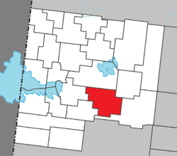 Location within Abitibi-Ouest RCM. | |
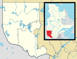 Poularies Location in western Quebec. | |
| Coordinates: 48°40′N 78°59′W / 48.667°N 78.983°WCoordinates: 48°40′N 78°59′W / 48.667°N 78.983°W[1] | |
| Country |
|
| Province |
|
| Region | Abitibi-Témiscamingue |
| RCM | Abitibi-Ouest |
| Settled | 1916 |
| Constituted | May 7, 1924 |
| Government[2] | |
| • Mayor | Claude Blais |
| • Federal riding | Abitibi—Témiscamingue |
| • Prov. riding | Abitibi-Ouest |
| Area[2][3] | |
| • Total | 168.20 km2 (64.94 sq mi) |
| • Land | 170.41 km2 (65.80 sq mi) |
|
There is an apparent contradiction between two authoritative sources | |
| Population (2011)[3] | |
| • Total | 679 |
| • Density | 4.0/km2 (10/sq mi) |
| • Pop 2006-2011 |
|
| • Dwellings | 276 |
| Time zone | EST (UTC−5) |
| • Summer (DST) | EDT (UTC−4) |
| Postal code(s) | J0Z 3E0 |
| Area code(s) | 819 |
| Highways |
|
| Website |
poularies |
Poularies is a municipality in northwestern Quebec, Canada in the Abitibi-Ouest Regional County Municipality. It covers 164.95 km² and had a population of 679 as of the Canada 2011 Census.
The municipality was incorporated on May 7, 1924.
Demographics
Population trend:[4]
- Population in 2011: 679 (2006 to 2011 population change: -2.0 %)
- Population in 2006: 693
- Population in 2001: 751
- Population in 1996: 838
- Population in 1991: 835
Private dwellings occupied by usual residents: 272 (total dwellings: 276)
Mother tongue:[5]
- English as first language: 3.6%
- French as first language: 95.0%
- English and French as first language: 0%
- Other as first language: 1.4%
Municipal council
- Mayor: Gino Levesque
- Councillors: Johanne Bolduc, Diane Bouchard, Sophie Dallaire, Solange Maheux, Lucie Noël, Patrick Thiffault
References
- ↑ Reference number 50912 of the Commission de toponymie du Québec (French)
- 1 2 "Poularies". Répertoire des municipalités (in French). Ministère des Affaires municipales, des Régions et de l'Occupation du territoire. Retrieved 2011-01-06.
- 1 2 "Poularies census profile". 2011 Census data. Statistics Canada. Retrieved 2011-01-06.
- ↑ Statistics Canada: 1996, 2001, 2006, 2011 census
- ↑ "Poularies community profile". 2006 Census data. Statistics Canada. Retrieved 2011-01-06.
 |
Macamic | Authier | | |
| Palmarolle | |
Taschereau | ||
| ||||
| | ||||
| Sainte-Germaine-Boulé | Taschereau |
| Towns | |
|---|---|
| Municipalities | |
| Townships | |
| Parishes | |
| Unorganized territories | |
| |
This article is issued from Wikipedia - version of the 1/26/2014. The text is available under the Creative Commons Attribution/Share Alike but additional terms may apply for the media files.