Val-Saint-Gilles, Quebec
| Val-Saint-Gilles | |
|---|---|
| Municipality | |
 Location within Abitibi-Ouest RCM. | |
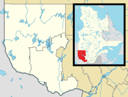 Val-Saint-Gilles Location in western Quebec. | |
| Coordinates: 48°58′N 79°07′W / 48.967°N 79.117°WCoordinates: 48°58′N 79°07′W / 48.967°N 79.117°W[1] | |
| Country |
|
| Province |
|
| Region | Abitibi-Témiscamingue |
| RCM | Abitibi-Ouest |
| Settled | c. 1935 |
| Constituted | April 1, 1939 |
| Government[2] | |
| • Mayor | Réjean Lambert |
| • Federal riding | Abitibi—Témiscamingue |
| • Prov. riding | Abitibi-Ouest |
| Area[2][3] | |
| • Total | 108.20 km2 (41.78 sq mi) |
| • Land | 110.52 km2 (42.67 sq mi) |
|
There is an apparent contradiction between two authoritative sources | |
| Elevation | 345 m (1,132 ft) |
| Population (2011)[3] | |
| • Total | 178 |
| • Density | 1.6/km2 (4/sq mi) |
| • Pop 2006-2011 |
|
| • Dwellings | 79 |
| Time zone | EST (UTC−5) |
| • Summer (DST) | EDT (UTC−4) |
| Postal code(s) | J0Z 3T0 |
| Area code(s) | 819 |
| Highways |
|
| Website |
valst-gilles |
Val-Saint-Gilles is a municipality in northwestern Quebec, Canada, in the Abitibi-Ouest Regional County Municipality about 24 kilometres (15 mi) north of La Sarre. It covers 110.54 km² and with a population of 154 in the Canada 2006 Census, it is the least populous incorporated municipality in the regional county.
It lies at the northern edge of the Abitibi Clay Belt. The undulating land is dotted with swamps, a few small lakes, and sand and gravel deposits. Its high point is marked by two hills near the village with an altitude of 345 metres (1,132 ft). The Turgeon River, the only notable river and tributary of the Harricana River, flows through the north-western part of the municipality.[4]
History
The first settlers, arriving circa 1935 as part of the Vautrin Settlement Plan, came from Clermont, Montreal, and Mont-Laurier. In 1937, they founded the Saint-Gilles-de-Clermont Parish, and two years later, the place separated from Clermont Township and was incorporated as the Municipality of Val-Saint-Gilles, named after Saint Giles.[1][4]
But because of the harsh land, the settlers could barely make a living and many soon left, reducing the population from over 600 persons to less than 200 today. Its residents mostly commute to La Sarre and the surrounding area, working particularly in the mining and forestry sectors.[1]
Demographics
Population
| Canada census – Val-Saint-Gilles, Quebec community profile | |||
|---|---|---|---|
| 2011 | 2006 | 2001 | |
| Population: | 178 (+4.1% from 2006) | 171 (+1.2% from 2001) | 169 (-9.6% from 1996) |
| Land area: | 110.52 km2 (42.67 sq mi) | 110.50 km2 (42.66 sq mi) | 110.50 km2 (42.66 sq mi) |
| Population density: | 1.6/km2 (4.1/sq mi) | 1.5/km2 (3.9/sq mi) | 1.5/km2 (3.9/sq mi) |
| Median age: | 46.0 (M: 43.5, F: 47.2) | 41.7 (M: 41.7, F: 41.5) | 40.6 (M: 38.8, F: 41.8) |
| Total private dwellings: | 79 | 78 | 79 |
| Median household income: | $.N/A | $.N/A | $.N/A |
| Notes: Income data for this area has been suppressed for data quality or confidentiality reasons. – References: 2011[3] 2006[5] 2001[6] | |||
| Historical Census Data - Val-Saint-Gilles, Quebec[7] | ||||||||||||||||||||||||||
|---|---|---|---|---|---|---|---|---|---|---|---|---|---|---|---|---|---|---|---|---|---|---|---|---|---|---|
|
|
| ||||||||||||||||||||||||
Language
| Canada Census Mother Tongue - Val-Saint-Gilles, Quebec[7] | ||||||||||||||||||
|---|---|---|---|---|---|---|---|---|---|---|---|---|---|---|---|---|---|---|
| Census | Total | French |
English |
French & English |
Other | |||||||||||||
| Year | Responses | Count | Trend | Pop % | Count | Trend | Pop % | Count | Trend | Pop % | Count | Trend | Pop % | |||||
| 2011 |
185 |
180 | |
97.30% | 0 | |
0.00% | 0 | |
0.00% | 5 | |
2.70% | |||||
| 2006 |
170 |
170 | |
100.00% | 0 | |
0.00% | 0 | |
0.00% | 0 | |
0.00% | |||||
| 2001 |
190 |
190 | |
100.00% | 0 | |
0.00% | 0 | |
0.00% | 0 | |
0.00% | |||||
| 1996 |
210 |
210 | n/a | 100.00% | 0 | n/a | 0.00% | 0 | n/a | 0.00% | 0 | n/a | 0.00% | |||||
Municipal council
- Mayor: Benoît Sarrazin
- Councillors: Kathy Beauchesne, Ghyslain-Guy Lavoie, Jean-Marie Lavoie, Marie-Rose Lavoie, Réal Paul, Daniel Poirier
See also
References
- 1 2 3 "Val-Saint-Gilles (Municipalité)" (in French). Commission de toponymie du Québec. Retrieved 2011-01-10.
- 1 2 "Val-Saint-Gilles". Répertoire des municipalités (in French). Ministère des Affaires municipales, des Régions et de l'Occupation du territoire. Retrieved 2011-01-10.
- 1 2 3 "Val-Saint-Gilles census profile". 2011 Census data. Statistics Canada. Retrieved 2011-01-10.
- 1 2 "La Municipalité" (in French). Municipalité de Val St-Gilles. Retrieved 2011-01-10.
- ↑ "2006 Community Profiles". Canada 2006 Census. Statistics Canada. March 30, 2011. Retrieved 2014-03-30.
- ↑ "2001 Community Profiles". Canada 2001 Census. Statistics Canada. February 17, 2012. Retrieved 2014-03-30.
- 1 2 Statistics Canada: 1996, 2001, 2006, 2011 census
 |
Baie-James | | ||
| Clermont | |
Rivière-Ojima | ||
| ||||
| | ||||
| Clermont, Chazel |
| Towns | |
|---|---|
| Municipalities | |
| Townships | |
| Parishes | |
| Unorganized territories | |
| |