Prairie City, Iowa
| Prairie City, Iowa | |
|---|---|
 | |
| Nickname(s): PC | |
| Motto: "Proud Of Our Past, Confident Of Our Future." | |
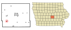 Location of Prairie City, Iowa | |
| Coordinates: 41°35′53″N 93°14′12″W / 41.59806°N 93.23667°WCoordinates: 41°35′53″N 93°14′12″W / 41.59806°N 93.23667°W | |
| Country |
|
| State |
|
| County | Jasper |
| Area[1] | |
| • Total | 1.21 sq mi (3.13 km2) |
| • Land | 1.21 sq mi (3.13 km2) |
| • Water | 0 sq mi (0 km2) |
| Elevation | 928 ft (283 m) |
| Population (2010)[2] | |
| • Total | 1,680 |
| • Estimate (2012[3]) | 1,674 |
| • Density | 1,388.4/sq mi (536.1/km2) |
| Time zone | Central (CST) (UTC-6) |
| • Summer (DST) | CDT (UTC-5) |
| ZIP code | 50228 |
| Area code(s) | 515 |
| FIPS code | 19-64470 |
| GNIS feature ID | 0460389 |
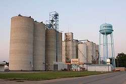
Prairie City is a city within Jasper County, Iowa, United States. The population was 1,680 at the 2010 census. It is twenty-two miles east of Des Moines.
History
Prairie City was founded by James Elliot in 1856, for whom it was originally named;[4] it was later changed because there was already another Elliot in the state.[5] The first resident was William Means, who built a tavern 2 miles (3.2 km) west of Elliot's cabin. The railroad first came through Prairie City in 1866. The first school in Prairie City was built on 1868(The Plainsmen) ; the city's district remained independent until a merger with that of Monroe in 1990, brought about by the destruction by fire of Monroe's high school. The new school district is called Prairie City-Monroe ("PCM") Community School district, home of the PCM Mustangs.
Prairie City's Historical Society was established in 1995. The Prairie City Historical Museum is located at 109 S. Main Street and open by appointment. Many artifacts from Prairie City's history are housed in the museum including the Dowden Potato Digger, which was originally manufactured in Prairie City.
The city was the subject of Douglas Bauer's popular reminiscence of change in small town Iowa from the 1950s through the 1970s, Prairie City, Iowa: Three Seasons at Home.[6]
Geography
Prairie City is located at 41°35′53″N 93°14′12″W / 41.59806°N 93.23667°W (41.598042, -93.236726).[7]
According to the United States Census Bureau, the city has a total area of 1.21 square miles (3.13 km2), all of it land.[1]
Demographics
| Historical populations | ||
|---|---|---|
| Year | Pop. | ±% |
| 1880 | 591 | — |
| 1890 | 684 | +15.7% |
| 1900 | 808 | +18.1% |
| 1910 | 764 | −5.4% |
| 1920 | 780 | +2.1% |
| 1930 | 793 | +1.7% |
| 1940 | 831 | +4.8% |
| 1950 | 834 | +0.4% |
| 1960 | 943 | +13.1% |
| 1970 | 1,141 | +21.0% |
| 1980 | 1,278 | +12.0% |
| 1990 | 1,366 | +6.9% |
| 2000 | 1,365 | −0.1% |
| 2010 | 1,680 | +23.1% |
| 2014 | 1,695 | +0.9% |
| 2015 | 1,709 | +0.8% |
| Source:"American FactFinder". United States Census Bureau. and Iowa Data Center Source: | ||
2010 census
As of the census[2] of 2010, there were 1,680 people, 631 households, and 468 families residing in the city. The population density was 1,388.4 inhabitants per square mile (536.1/km2). There were 678 housing units at an average density of 560.3 per square mile (216.3/km2). The racial makeup of the city was 96.4% White, 0.5% African American, 0.2% Native American, 1.0% Asian, 0.1% Pacific Islander, 0.7% from other races, and 1.2% from two or more races. Hispanic or Latino of any race were 1.5% of the population.
There were 631 households of which 39.6% had children under the age of 18 living with them, 58.3% were married couples living together, 11.4% had a female householder with no husband present, 4.4% had a male householder with no wife present, and 25.8% were non-families. 22.3% of all households were made up of individuals and 10.6% had someone living alone who was 65 years of age or older. The average household size was 2.61 and the average family size was 3.07.
The median age in the city was 33.7 years. 31.1% of residents were under the age of 18; 5.2% were between the ages of 18 and 24; 29.1% were from 25 to 44; 22.4% were from 45 to 64; and 12.4% were 65 years of age or older. The gender makeup of the city was 47.6% male and 52.4% female.
2000 census
As of the census[9] of 2000, there were 1,365 people, 553 households, and 388 families residing in the city. The population density was 1,182.5 people per square mile (458.3/km²). There were 567 housing units at an average density of 491.2 per square mile (190.4/km²). The racial makeup of the city was 98.46% White, 0.29% African American, 0.22% Native American, 0.22% Asian, 0.07% Pacific Islander, 0.29% from other races, and 0.44% from two or more races. Hispanic or Latino of any race were 0.95% of the population.
There were 553 households out of which 32.0% had children under the age of 18 living with them, 62.2% were married couples living together, 5.6% had a female householder with no husband present, and 29.8% were non-families. 27.5% of all households were made up of individuals and 15.4% had someone living alone who was 65 years of age or older. The average household size was 2.40 and the average family size was 2.93.
In the city the population was spread out with 23.9% under the age of 18, 5.5% from 18 to 24, 28.4% from 25 to 44, 22.7% from 45 to 64, and 19.5% who were 65 years of age or older. The median age was 40 years. For every 100 females there were 90.4 males. For every 100 females age 18 and over, there were 85.9 males.
The median income for a household in the city was $42,750, and the median income for a family was $54,205. Males had a median income of $32,389 versus $25,500 for females. The per capita income for the city was $19,864. About 3.4% of families and 5.6% of the population were below the poverty line, including 6.0% of those under age 18 and 8.2% of those age 65 or over.
Arts and culture
The city annually celebrates Prairie Days, an "old settler's" festival, in June.
Parks and recreation
The Neal Smith National Wildlife Refuge, located adjacent to the city, includes 5,500 acres (22 km2) of land that has been restored to Iowa's original rolling hills and tall grass prairies, plus several miles of surfaced trails, an auto tour, and the Prairie Learning Center.[10]
Prairie City has is also building a recreational park. When complete, the park will include sports facilities, playgrounds, and open areas.[11]
Transportation
Prairie City is accessible from the east and west via Highway 163. Highway 117 and County Route S6G allow access from the north and south respectively.
Gallery
 Downtown
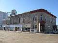 Another view of downtown
References
- 1 2 "US Gazetteer files 2010". United States Census Bureau. Retrieved 2012-05-11.
- 1 2 "American FactFinder". United States Census Bureau. Retrieved 2012-05-11.
- ↑ "Population Estimates". United States Census Bureau. Retrieved 2013-05-23.
- ↑ The History of Jasper County, Iowa, Containing a History of the County, Its Cities, Towns, &c. Western Historical. 1878. p. 500.
- ↑ "Dr. Bill Tells Ancestor Stories: Prairie City". Retrieved 5 August 2010.
- ↑ Bauer, Douglas (2008) [1979]. Prairie City, Iowa: Three Seasons at Home. Iowa City: University of Iowa Press.
- ↑ "US Gazetteer files: 2010, 2000, and 1990". United States Census Bureau. 2011-02-12. Retrieved 2011-04-23.
- ↑ "Census of Population and Housing". Census.gov. Retrieved June 4, 2015.
- ↑ "American FactFinder". United States Census Bureau. Retrieved 2008-01-31.
- ↑ Friends of the Prairie Learning Center, Neal Smith National Wildlife Refuge, 2007. Accessed 2009-01-03.
- ↑ Design of Future Recreational Complex, Prairie City. Accessed 2009-12-13.
External links
| Wikimedia Commons has media related to Prairie City, Iowa. |
Municipalities and communities of Jasper County, Iowa, United States | ||
|---|---|---|
| Cities | ||
| Townships | ||
| Unincorporated communities | ||
| Footnotes | ‡This populated place also has portions in an adjacent county or counties | |