Province of Lower Silesia
| Province of Lower Silesia Provinz Niederschlesien | ||||||
| Province of Prussia | ||||||
| ||||||
| ||||||
 within the Free State of Prussia. | ||||||
| Capital | Breslau (now Wrocław) | |||||
| History | ||||||
| • | Established | 1919 | ||||
| • | Merged into Silesia Province | 1938–1941 | ||||
| • | Disestablished | 1945 | ||||
| Area | ||||||
| • | 1925 | 26,616 km2 (10,276 sq mi) | ||||
| Population | ||||||
| • | 1925 | 3,132,135 | ||||
| Density | 117.7 /km2 (304.8 /sq mi) | |||||
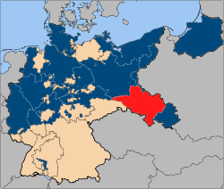
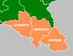
The Province of Lower Silesia (German: Provinz Niederschlesien; Silesian German: Provinz Niederschläsing; Polish: Prowincja Dolny Śląsk; Silesian: Prowincyjŏ Dolny Ślůnsk) was a province of the Free State of Prussia from 1919 to 1945. Between 1938 and 1941 it was reunited with Upper Silesia as the Province of Silesia. The capital of Lower Silesia was Breslau (now Wrocław in Poland). The province was further divided into two administrative regions (Regierungsbezirke), Breslau and Liegnitz.[1]
The province was not congruent with the historical region of Lower Silesia, which now lies mainly in Poland. It additionally comprised the Upper Lusatian districts of Görlitz, Rothenburg and Hoyerswerda in the west, that until 1815 had belonged to the Kingdom of Saxony, as well as the former County of Kladsko in the southeast.
The province was disestablished at the end of World War II and with the implementation of the Oder–Neisse line in 1945, the area east of the Neisse river fell to the Republic of Poland. The smaller western part was incorporated into the German states of Saxony and Brandenburg.
Administrative regions[2]
Regierungsbezirk Breslau
Urban districts / Stadtkreise
- City of Breslau
- City of Brieg
- City of Schweidnitz
- City of Waldenburg
Rural districts / Landkreise
- Landkreis Breslau
- Landkreis Brieg
- Landkreis Frankenstein
- Landkreis Glatz
- Landkreis Groß Wartenberg
- Landkreis Guhrau
- Landkreis Habelschwerdt
- Landkreis Militsch
- Landkreis Namslau
- Landkreis Neumarkt
- Landkreis Oels
- Landkreis Ohlau
- Landkreis Reichenbach (im Eulengebirge)
- Landkreis Schweidnitz
- Landkreis Strehlen
- Landkreis Trebnitz
- Landkreis Waldenburg
- Landkreis Wohlau
Regierungsbezirk Liegnitz


Urban districts / Stadtkreise
- City of Glogau
- City of Görlitz
- City of Hirschberg im Riesengebirge
- City of Liegnitz
Rural districts / Landkreise
- Landkreis Bunzlau
- Landkreis Fraustadt
- Landkreis Freystadt i. Niederschles.
- Landkreis Glogau
- Landkreis Görlitz
- Landkreis Goldberg
- Landkreis Grünberg
- Landkreis Hirschberg
- Landkreis Hoyerswerda
- Landkreis Jauer
- Landkreis Landeshut
- Landkreis Lauban
- Landkreis Liegnitz
- Landkreis Löwenberg
- Landkreis Lüben
- Landkreis Rothenburg (Ob. Laus.)
- Landkreis Sprottau

