Quincy Center (MBTA station)
QUINCY CENTER
QUINCY CENTER | ||||||||||||||||||||||||
|---|---|---|---|---|---|---|---|---|---|---|---|---|---|---|---|---|---|---|---|---|---|---|---|---|
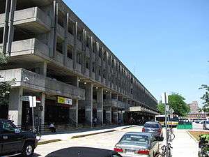
 Quincy Center MBTA station is combined with a now-closed parking structure | ||||||||||||||||||||||||
| Location |
1300 Hancock Street at Washington Street Quincy, MA 02169 | |||||||||||||||||||||||
| Coordinates | 42°15′07″N 71°00′20″W / 42.25194°N 71.00556°WCoordinates: 42°15′07″N 71°00′20″W / 42.25194°N 71.00556°W | |||||||||||||||||||||||
| Owned by | Massachusetts Bay Transportation Authority | |||||||||||||||||||||||
| Line(s) | ||||||||||||||||||||||||
| Platforms |
1 side platform (Commuter Rail) 1 island platform (Red Line) | |||||||||||||||||||||||
| Tracks |
1 (Commuter Rail) 2 (Red Line) | |||||||||||||||||||||||
| Construction | ||||||||||||||||||||||||
| Parking |
872 spaces ($5.00 fee) 16 accessible spaces | |||||||||||||||||||||||
| Bicycle facilities | 20 spaces | |||||||||||||||||||||||
| Disabled access | Yes | |||||||||||||||||||||||
| Other information | ||||||||||||||||||||||||
| Fare zone |
1 (Commuter Rail) (Exit fare zone on Red Line until 1980) | |||||||||||||||||||||||
| History | ||||||||||||||||||||||||
| Opened | September 1, 1971[1] | |||||||||||||||||||||||
| Traffic | ||||||||||||||||||||||||
| Passengers (2013) | 8,655 (weekday average boardings)[2] | |||||||||||||||||||||||
| Services | ||||||||||||||||||||||||
| ||||||||||||||||||||||||
Quincy Center is an intermodal transfer station located between Hancock Street and Burgin Parkway in the Quincy Center district of Quincy, Massachusetts. It serves as a station stop on the Red Line subway and the Old Colony Lines and Greenbush Line of the MBTA Commuter Rail, as well as a major terminal for MBTA Bus routes in the Quincy area. Opened in 1971, the station is covered by a large parking garage which was closed in 2012 due to structural problems.
Quincy Center station is partially handicapped accessible – all buses and trains are accessible from the Hancock Street entrance, but due to the garage closure the Burgin Parkway entrance is no longer accessible.
History
Old Colony Railroad

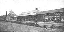
The Old Colony Railroad opened its main line from South Boston to Plymouth on November 10, 1845.[3] Quincy station was located at Quincy Square behind the town hall. The station was rebuilt in the late 1890s; that iteration consisted of a low brick building with two side platforms (very similar to the extant building at Norwood Central) with shelters serving the line's two tracks.[4][5] Service on the former Old Colony lines, operated by the New Haven Railroad since 1893, ended on June 30, 1959.[3] The Quincy depot was later demolished.
Red Line
The 1926 Report on Improved Transportation Facilities and 1945–47 Coolidge Commission Report recommended the Cambridge-Dorchester Line receive a branch to Braintree along the Old Colony right-of-way.[6][7] In May 1966, the MBTA began construction on the South Shore Line branch of the Cambridge-Dorchester Line (which was renamed the Red Line in 1967).
The line was intended to be completed to Braintree by May 1969.[4][8] Although the South Shore Line was planned to extend to Braintree and possibly even to Holbrook or Brockton, it was temporarily terminated at Quincy Center due to disagreements about station locations and other issues.[9]
North Quincy, Wollaston, and Quincy Center stations opened on September 1, 1971.[1] The other two stations had large surface lots, but due to limited land availability, Quincy Center station included a 5-story parking garage located over the two tracks and single island platform, with 700 spots for Red Line riders and 200 spots for local shoppers. The $5.877 million station, located a block north of the Old Colony station site, was designed Samuel Glaser Associates and built by J.F. White.[1] The new stations required a double fare to be paid on entry and an exit fare upon leaving; this was also briefly put in place on the north end of the Haymarket North Extension.
Further construction began in 1977, and the line was extended to Braintree on March 22, 1980.[8] The exit fare was abolished from Quincy Center north at this time, though Braintree and Quincy Adams had the double fare until 2007.[10]
Commuter Rail
In 1990, the MBTA began construction on the restoration of parts of the former Old Colony system. A single commuter rail track was built through the west side of the station, with a full-length high-level side platform attached to the station. Service began on the Middleborough/Lakeville Line and Plymouth/Kingston Line on September 29, 1997. The Greenbush Line opened on October 31, 2007, with some of its trains stopping at Quincy Center as well.[8]
Some seasonal CapeFLYER trains stopped at Quincy Center in 2013 and 2014, but did not starting with the 2015 season due to schedule changes.[11]
Garage closure
On July 4, 2012, the Quincy Center parking garage was closed indefinitely due to structural issues. Built in 1970-71, the garage is the oldest anywhere on the MBTA system. Red Line, MBTA Commuter Rail, and MBTA Bus service to the station continue as normal; however, the Burgin Parkway entrance is no longer handicapped accessible.[12]
In March 2016, the city released preliminary plans for a replacement structure, paid for by a $970,000 federal grant.[13] Three structures would be built: a new garage with the same number of spaces, a "justice center" with a new Quincy District Court, and an office building for the National Park Service and its bus shuttle to Adams National Historical Park. The garage would have street-level retail locations.[14] The busways would be relocated to the Burgin Parkway side and a roof added; the kiss-and-ride dropoff lane would remain on the Hancock Street side. The project is estimated to cost $52 million; the city proposes to use $10 million in state money approved in 2014, $20 million in federal grants, and $22 million from a private partner who would operate the facility for several decades.[15] No city money will be used to pay for the project.[13]
In July and August 2016, bracing was installed in the closed garage to stabilize it while the new structure is designed.[16][17] The September, the USDOT granted $4.2 million for planning the new station.[18] In October 2016, Quincy mayor Thomas Koch announced that the courthouse part of the proposal would be withdrawn due to local opposition and a lack of available state funds. Planning for the station and office building will continue, although the MBTA has no plans to remove the old garage yet.[17]
Bus connections

Through the first half of the 20th century, Quincy was served by a number of Eastern Massachusetts Street Railway streetcar and bus lines, with both local routes and through service as far as Providence, Rhode Island. Some routes continued through Quincy to Fields Corner via Hancock Street and Neponset Avenue. After a legal battle, the MBTA acquired the remaining Eastern Mass lines on March 30, 1968. When Quincy Center opened in 1971, most of the Fields Corner routes were cut back to the new terminus.[8]
Quincy Center is now the terminal of 15 MBTA Bus routes which provide local and short-distance intercity service. All routes loop through the surface parking lot and into a dedicated busway on the Hancock Street side of the station; there is no bus service on the Burgin parkway side.[19]
- 210 Quincy Center Station - North Quincy Station or Fields Corner Station via Hancock Street & Neponset Avenue
- 211 Quincy Center Station - Squantum via Montclair & North Quincy Station
- 212 Quincy Center Station - North Quincy Station via Billings Road
- 214 Quincy Center Station - Germantown via Sea Street & O'Brien Towers
- 215 Quincy Center Station - Ashmont Station via West Quincy & East Milton Square
- 216 Quincy Center Station - Houghs Neck via Sea Street
- 217 Quincy Center Station - Ashmont Station via Beale Street, Wollaston, & East Milton Square
- 220 Quincy Center Station - Hingham Center via Fore River Bridge
- 221 Quincy Center Station - Fort Point via Bicknell Square
- 222 Quincy Center Station - East Weymouth via Bicknell Square
- 225 Quincy Center - Weymouth Landing via Quincy Avenue & Shaw Street or Desmoines Road
- 230 Quincy Center Station - Montello Commuter Rail Station via Holbrook & Braintree Station
- 236 Quincy Center Station - South Shore Plaza via East Braintree & Braintree Station
- 238 Quincy Center Station - Holbrook/Randolph Commuter Rail Station
- 245 Quincy Center Station - Mattapan Station via Quincy Hospital & Pleasant Street
Under plans for redeveloping the station site, the busway would be relocated to the Burgin Parkway side of the station.
Station layout
| Parking garage | - | Parking garage (closed since July 2012) |
| G | Street Level | Exit/Entrance |
| P Platform level |
Inbound | ← Red Line toward Alewife (Wollaston) |
| Island platform, doors will open on the left | ||
| Outbound | → Red Line toward Braintree (Quincy Adams) → | |
| Commuter rail platform | ← Commuter rail lines → ← CapeFLYER does not stop here → | |
| Side platform, doors will open on the left/right | ||
References
- 1 2 3 "Off Hancock Street". Historic and Architectural Survey Quincy, Massachusetts. Thomas Crane Public Library, Quincy, Mass. 1986. p. 77. Retrieved 2007-10-02.
- ↑ "Ridership and Service Statistics" (PDF) (14 ed.). Massachusetts Bay Transportation Authority. 2014. Retrieved 10 May 2015.
- 1 2 Humphrey, Thomas J. & Clark, Norton D. (1985). Boston's Commuter Rail: The First 150 Years. Boston Street Railway Association. ISBN 9780685412947.
- 1 2 Cheney, Frank (2002). Boston's Red Line: Bridging the Charles from Alewife to Braintree. Arcadia Publishing. pp. 111–112. ISBN 9780738510477.
- ↑ Roy, John H. Jr. (2007). A Field Guide to Southern New England Railroad Depots and Freight Houses. Branch Line Press. pp. 210–211. ISBN 9780942147087.
- ↑ Central Transportation Planning Staff (15 November 1993). "The Transportation Plan for the Boston Region - Volume 2". National Transportation Library. Retrieved 25 July 2014.
- ↑ Boston Elevated Railway and Boston Department of Public Utilities (1945), Boston Rapid Transit System & Proposed Extentions 1945 - Metropolitan Transit Recess Commission Air View
- 1 2 3 4 Belcher, Jonathan (27 December 2014). "Changes to Transit Service in the MBTA district" (PDF). NETransit. Retrieved 10 May 2015.
- ↑ Jordan, Robert (3 April 1977). "What the MBTA may look like in 10 years". Boston Globe. p. 32 – via Proquest Historical Newspapers. (subscription required (help)).
- ↑ Waltz, Vicky (11 November 2006). "End of the Line for Free T". BU Today. Retrieved 1 July 2012.
- ↑ "CapeFLYER Service Begins Memorial Day Weekend" (Press release). Massachusetts Bay Transportation Authority. 13 May 2015. Retrieved 13 May 2015.
- ↑ Bartlett, Jessica (3 July 2012). "Quincy Center T garage closed due to structural problems". Boston Globe. Retrieved 4 July 2012.
- 1 2 Ronan, Patrick (17 March 2016). "Quincy official: City's taxpayers won't shoulder any cost of MBTA project". Patriot Ledger. Retrieved 18 March 2016.
- ↑ Ronan, Patrick (17 February 2016). "Three structures, new bus terminal in redesign for Quincy Center MBTA station". Patriot Ledger. Retrieved 4 March 2016.
- ↑ Jackson, Scott (2 March 2016). "Meeting On Quincy Center Station March 10". Quincy Sun. Retrieved 4 March 2016.
- ↑ Drue, Nancy (August 5, 2016). "Quincy Center MBTA garage bracing continues". Quincy Quarry. Retrieved August 12, 2016.
- 1 2 Ronan, Patrick (October 4, 2016). "Courthouse no longer part of Quincy Center T plans". Patriot Ledger. Retrieved October 7, 2016.
- ↑ Ronan, Patrick (September 9, 2016). "Feds grant $4.2 million to overhaul of Quincy Center MBTA station". Patriot Ledger. Retrieved October 7, 2016.
- ↑ "Quincy Center Station Neighborhood Map" (PDF). Massachusetts Bay Transportation Authority. July 2012. Retrieved 4 March 2016.
External links
| Wikimedia Commons has media related to Quincy Center (MBTA station). |
