Rainbow, Oregon
| Rainbow | |
|---|---|
| Unincorporated community | |
|
Road and settlements in Rainbow | |
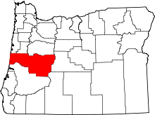
 Rainbow  Rainbow Location within the state of Oregon | |
| Coordinates: 44°10′1″N 122°14′14″W / 44.16694°N 122.23722°WCoordinates: 44°10′1″N 122°14′14″W / 44.16694°N 122.23722°W | |
| Country | United States |
| State | Oregon |
| County | Lane |
| Elevation | 1,211 ft (369 m) |
| Time zone | Pacific (PST) (UTC-8) |
| • Summer (DST) | PDT (UTC-7) |
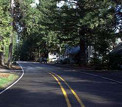
Rainbow is an unincorporated community in Lane County, Oregon, United States. It lies off Oregon Route 126, northeast of Eugene. Rainbow's elevation is 1,211 feet (369 m).[1] A post office was established on July 1, 1924, and closed August 31, 1937. The post office got its name from the rainbow trout that swim in the McKenzie River.[2][3]
References
- ↑ "Rainbow". Geographic Names Information System. United States Geological Survey. November 28, 1980. Retrieved August 3, 2011.
- ↑ McArthur, Lewis A.; McArthur, Lewis L. (2003) [1928]. Oregon Geographic Names (7th ed.). Portland, Oregon: Oregon Historical Society Press. p. 796. ISBN 978-0875952772.
- ↑ "Names of Lane County Communities Reveal Interesting Histories, Anecdotes". Eugene Register-Guard. 4 January 1942. p. 4. Retrieved 23 April 2015.
This article is issued from Wikipedia - version of the 7/30/2016. The text is available under the Creative Commons Attribution/Share Alike but additional terms may apply for the media files.