Vida, Oregon
| Vida | |
|---|---|
| Unincorporated community | |
|
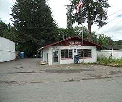
Vida's post office | |
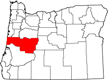
 Vida  Vida Location within the state of Oregon | |
| Coordinates: 44°8′46″N 122°34′7″W / 44.14611°N 122.56861°WCoordinates: 44°8′46″N 122°34′7″W / 44.14611°N 122.56861°W | |
| Country | United States |
| State | Oregon |
| County | Lane |
| Elevation[1] | 823 ft (251 m) |
| Time zone | Pacific (PST) (UTC-8) |
| • Summer (DST) | PDT (UTC-7) |
| ZIP code | 97488 |
| Area code(s) | 458 and 541 |
Vida is an unincorporated community in Lane County, Oregon, United States.[1] It is located on Oregon Route 126 and the McKenzie River.[2]
Vida was originally named "Gate Creek", but this caused confusion with a community of "Gates Creek" in Washington County, so the name of the postmaster's daughter was selected instead.[2] The Vida post office was established on April 12, 1898.[2] The postmaster was Francis A. Pepiot.[2]
Vida is home to the historic Goodpasture Bridge, a covered bridge that was added to the National Register of Historic Places in 1979.[3] It is the second-longest covered bridge in Oregon.[4]
References
- 1 2 "Vida". Geographic Names Information System. United States Geological Survey. 28 November 1980. Retrieved April 16, 2011.
- 1 2 3 4 McArthur, Lewis A.; McArthur, Lewis L. (2003) [1928]. Oregon Geographic Names (7th ed.). Portland, Oregon: Oregon Historical Society Press. p. 993. ISBN 978-0875952772.
- ↑ "Oregon National Register List" (PDF). Oregon Parks and Recreation Department. January 5, 2009. Retrieved 2009-09-25.
- ↑ "Goodpasture Covered Bridge". Lane County, Oregon. Retrieved 2009-09-25.
External links
This article is issued from Wikipedia - version of the 7/30/2016. The text is available under the Creative Commons Attribution/Share Alike but additional terms may apply for the media files.