Ravensbourne, Queensland
| Ravensbourne Queensland | |||||||||||||
|---|---|---|---|---|---|---|---|---|---|---|---|---|---|
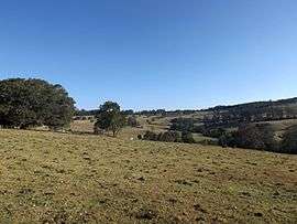 The rolling hills of Ravensbourne, 2014 | |||||||||||||
 Ravensbourne | |||||||||||||
| Coordinates | 27°21′S 152°9′E / 27.350°S 152.150°ECoordinates: 27°21′S 152°9′E / 27.350°S 152.150°E | ||||||||||||
| Population | 367 | ||||||||||||
| Postcode(s) | 4352 | ||||||||||||
| LGA(s) | Toowoomba Region | ||||||||||||
| State electorate(s) | Nanango | ||||||||||||
| Federal Division(s) | Maranoa | ||||||||||||
| |||||||||||||
Ravensbourne is a locality in the Toowoomba Region local government area of Darling Downs region in southern Queensland, Australia. At the 2011 Australian Census Ravensbourne and surrounds recorded a population of 367.[1] The locality is crossed from east to west by the Esk–Hampton Road.
In the far north is reservoir created behind the Cressbrook Dam. Most of the area is within the catchment of the dammed Cressbrook Creek, a tributary of the Brisbane River. However a small section in the southeast lies within the Lockyer Creek catchment. In this part lies the Ravensbourne National Park. In the west Preserverance Creek marks the boundary.
References
- ↑ Australian Bureau of Statistics (31 October 2012). "Redbank Creek (State Suburb)". 2011 Census QuickStats. Retrieved 30 October 2014.
External links
![]() Media related to Ravensbourne, Queensland at Wikimedia Commons
Media related to Ravensbourne, Queensland at Wikimedia Commons
This article is issued from Wikipedia - version of the 6/2/2015. The text is available under the Creative Commons Attribution/Share Alike but additional terms may apply for the media files.