Redwood, Queensland
| Redwood Toowoomba, Queensland | |||||||||||||
|---|---|---|---|---|---|---|---|---|---|---|---|---|---|
 Warrego Highway, 2014 | |||||||||||||
 Redwood | |||||||||||||
| Coordinates | 27°34′05″S 151°59′20″E / 27.568°S 151.989°ECoordinates: 27°34′05″S 151°59′20″E / 27.568°S 151.989°E | ||||||||||||
| Population | 17 (2011 census)[1] | ||||||||||||
| Postcode(s) | 4350 | ||||||||||||
| Location | 5 km (3 mi) E of Toowoomba | ||||||||||||
| LGA(s) | Toowoomba Region | ||||||||||||
| State electorate(s) | Toowoomba North | ||||||||||||
| Federal Division(s) | Groom | ||||||||||||
| |||||||||||||
Redwood is a suburb of Toowoomba, Queensland, Australia, located 5 kilometres (3 mi) east of the city centre via Warrego Highway. Half of the suburb's area consists of Redwood Park, after which the suburb was named in 1981;[2] the rest, to the south of the highway, is mostly crown land. The residents of Redwood live along the suburb's boundary with East Toowoomba.[3]
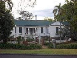
Glen Alpine villa, 2014
The suburb is home to the heritage-listed Glen Alpine villa.
Demographics
At the 2011 census, Redwood had a population of 17 people.[1] The suburb had a SEIFA score of 1171, placing it ahead of all other suburbs in the district.[4]
References
- 1 2 Australian Bureau of Statistics (31 October 2012). "Redwood (State Suburb)". 2011 Census QuickStats. Retrieved 9 November 2014.
- ↑ "Redwood (entry 48051)". Queensland Place Names. Queensland Government. Retrieved 28 August 2015.
- ↑ Brisway Publishing (2008). Brisway: Greater Brisbane, Sunshine Coast, Gold Coast and Toowoomba. p. Map T221, T261. ISBN 978-0-909439-30-9.
- ↑ Australian Bureau of Statistics (25 March 2009). "2033.0.55.001 - Census of Population and Housing: Socio-Economic Indexes for Areas (SEIFA), Australia - Data only, 2006". Retrieved 5 June 2011.
This article is issued from Wikipedia - version of the 10/4/2015. The text is available under the Creative Commons Attribution/Share Alike but additional terms may apply for the media files.