Upper Yarraman, Queensland
| Upper Yarraman Queensland | |||||||||||||
|---|---|---|---|---|---|---|---|---|---|---|---|---|---|
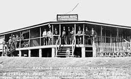 Cedars Hotel, 1913 | |||||||||||||
 Upper Yarraman | |||||||||||||
| Coordinates | 26°54′15″S 151°52′48″E / 26.90417°S 151.88000°ECoordinates: 26°54′15″S 151°52′48″E / 26.90417°S 151.88000°E | ||||||||||||
| Population | 1,230 (2011)[1] | ||||||||||||
| Established | 1897 | ||||||||||||
| Postcode(s) | 4614 | ||||||||||||
| LGA(s) | Toowoomba Region | ||||||||||||
| State electorate(s) | Nanango | ||||||||||||
| Federal Division(s) | Maranoa | ||||||||||||
| |||||||||||||
Upper Yarraman is a locality within the Toowoomba Region on the Darling Downs in Queensland, Australia. At the 2011 Census, Upper Yarraman and surrounding area had a population of 1,230.[1]
The New England Highway runs through Upper Yarraman. It is part of the Cooyar Creek catchment, a tributary of the Brisbane River.
History
The area was first surveyed in 1897. It was then opened for selection with a requirement being the land had to be cleared and cultivated.
The name of Yarraman is derived from the aboriginal word meaning horse.[2] Although the origin of the word Yarraman is unknown, it is thought to be derived from the word "yira" which means large teeth.[3]
Yarraman Upper State School (formerly Yarraman Creek Upper) opened on 31 January 1905 and closed on 31 December 2002.[4]
On a road junction of Upper Yarraman became a meeting place. The Cedars hotel first licensee was Jack Thompson in 1913. The Hotel was used for the Ministerial Party Luncheon the day after the railway opening in Yarraman in 1913. The hotel burnt down in 1927, was rebuilt, then burnt down again in 1960.
The Upper Yarraman Farmers' Hall, was originally the Phoenix Picture Theatre in Blackbutt. The hall was dismantled and re-erected at its current location in 1945, on a piece of land donated by Mr. Horace Lougheed.[5]
In February 1924 it was decided to establish a trunk line and public telegraph office.[6] The township consisted of a telephone exchange which was used until 1986, post office till 1974, and a Methodist church which was later moved into Yarraman township to become part of the Uniting Church.
There is a pine forest on the northern side of the Yarraman Creek Valley, just beyond the boundary of Upper Yarraman, which is a plantation of hoop pines planted in around 1939 to 1940.[7]
References
- 1 2 "Upper Yarraman". Australian Bureau of Statistics. Retrieved 25 October 2014.
- ↑ "Yarraman Queensland Places". Retrieved 7 November 2014.
- ↑ "Queensland places names search". Retrieved 7 November 2014.
- ↑ "Qld State Archives". Retrieved 7 November 2014.
- ↑ "UPPER YARRAMAN FARMERS' HALL.". Queensland Times (Ipswich) (Qld. : 1909 - 1954). Ipswich) (Qld.: National Library of Australia. 3 November 1945. p. 4 Edition: DAILY. Retrieved 7 November 2014.
- ↑ "UPPER YARRAMAN TELEPHONE.". Queensland Times (Ipswich) (Qld. : 1909 - 1954). Ipswich) (Qld.: National Library of Australia. 19 February 1924. p. 4 Edition: DAILY. Retrieved 7 November 2014.
- ↑ Glass, Gloria J. (Gloria Jeanette); Rosalie Shire Historical Society (1996), A traveller's guide, not to the whole galaxy, but only to Rosalie Shire, Rosalie Shire Historical Society, ISBN 978-0-646-27823-0