Ravine des Casoars
| Ravine des Casoars | |
|---|---|
|
Ravine des Casoars | |
 Ravine des Casoars | |
| Long-axis direction | east - west |
| Long-axis length | 3 kilometres (1.9 mi) |
| Depth | 100 metres (330 ft) |
| Geography | |
| Coordinates | 35°47′34.72″S 136°34′44.57″E / 35.7929778°S 136.5790472°ECoordinates: 35°47′34.72″S 136°34′44.57″E / 35.7929778°S 136.5790472°E |
Ravine des Casoars (English: Ravine of the Cassowaries) is a gorge and an associated drainage basin located on the west coast of Kangaroo Island in South Australia about 95 kilometres (59 mi) west of Kingscote.
Description
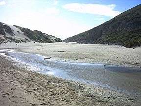
The Ravine des Casoars is a steep sided valley of 3 kilometres (1.9 mi) length with an east-west alignment and with a maximum depth of 100 metres (330 ft).[1] The ravine drains a catchment area of approximately 9,600 hectares (24,000 acres) within the western end of Kangaroo Island.[2] The ravine meets the sea on the west coast of Kangaroo Island via a gap of about 120 metres (390 ft) width in the coastline’s continuous cliff line. A beach is located between the two headlands. The beach and an accompanying sand dune extends about 600 metres (2,000 ft) back into the south side of the ravine to an elevation of about 100 metres (330 ft) while a creek and an associated lagoon flows on the north side of the ravine.[1] The base of the cliffs on the northern side of the beach had eroded with the result of caves being formed. As of 1965, two caves were described. The first known as ‘K5’ which accommodated at the time in tis entrance, a little penguin rookery, was described as being 50 feet (15 m) wide and as having a ‘massive rockfall’ and decoration including flowstone. Adjacent to ‘K5’ is ‘K16’ which was described as being 400 feet (120 m) long, 40 feet (12 m) wide and 10 feet (3.0 m) high with decoration consisting of rimstone and stalactites.[1][3]
History
Aboriginal use
Aboriginal sites have been identified by the South Australian Museum at Ravine des Casoars. As of 1999, radiocarbon dating of material recovered via archaeological excavation from sites at Cape du Couedic and Rocky River to the south of the ravine’s catchment area suggest Aboriginal presence in the western end of Kangaroo Island from approximately 7,500 years BP to as recent as 350–400 years BP.[4][5]
European discovery
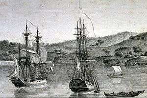
The members of the Baudin expedition of 1800-03 were the first Europeans known to have visited the ravine. Baudin reportedly named the ravine after the numbers of the now-extinct Kangaroo Island Emu present at the time and which he mistook for the Cassowary.[6] Reliable witnesses have reported the existence of an inscription in one of the caves on the coast where Ravine des Casoars meets the sea bearing Baudin’s name and several other names of French origin. As of 1999, the inscription had not been located, possibly due to temporary obscurement by the movement of sand within the cave and other changes in the level of the cave floor.[7]
Protected area status
Ravine des Casoars is currently located within the protected area of the same name - the Ravine des Casoars Wilderness Protection Area.[8]
References
- 1 2 3 "Ravine Des Casoars UNPATROLLED BEACH". Surf Life Saving Australia. Retrieved 3 May 2014.
- ↑ "Estuaries Information Package - Kangaroo Island NRM region" (PDF). Department for Environment and Heritage. 2007. p. 5. Retrieved 3 May 2014.
- ↑ Sexton, R.T. (April 1965). "Caves of the coastal areas of South Australia" (PDF). Helcitite,the Journal of Australasian Cave Research. 3 (3): 54–55.
- ↑ "Flinders Chase National Park, Kelly Hill Conservation Park, Ravine des Casoars Wilderness Protection Area and Cape Bouguer Wilderness Protection Area Management Plans" (PDF). Department for Environment, Heritage and Aboriginal Affairs. 1999. p. 37. Retrieved 1 May 2014.
- ↑ Robinson, A. C.; Armstrong, D. M. (eds.). A Biological Survey of Kangaroo Island, South Australia, 1989 & 1990 (PDF). Adelaide, SA: Heritage and Biodiversity Section, Department for Environment, Heritage and Aboriginal Affairs, South Australia. pp. 34–35. ISBN 0 7308 5862 6. Retrieved 1 May 2014.
- ↑ "Parks of Kangaroo Island Visitor Information" (PDF). Department of Environment and Natural Resources. p. 46. Retrieved 3 May 2014.
- ↑ "Flinders Chase National Park, Kelly Hill Conservation Park, Ravine des Casoars Wilderness Protection Area and Cape Bouguer Wilderness Protection Area Management Plans" (PDF). Department for Environment, Heritage and Aboriginal Affairs. 1999. pp. 40–41. Retrieved 1 May 2014.
- ↑ "Flinders Chase National Park, Kelly Hill Conservation Park, Ravine des Casoars Wilderness Protection Area and Cape Bouguer Wilderness Protection Area Management Plans" (PDF). Department for Environment, Heritage and Aboriginal Affairs. 1999. p. 6. Retrieved 1 May 2014.
| Major townships | |||||||||||||||
|---|---|---|---|---|---|---|---|---|---|---|---|---|---|---|---|
| Beaches | |||||||||||||||
| Coastal features |
| ||||||||||||||
| Protected areas |
| ||||||||||||||
| Islands adjacent to Kangaroo Island coast | |||||||||||||||
| Related and uncategorised | |||||||||||||||
| |||||||||||||||
Australian places named by French explorers in the 18th and 19th centuries | ||
|---|---|---|
| South Australia |
|  |
| Western Australia | ||
Only places with the name still in use in either the original or anglicised version are listed above. Many names have been anglicised; for these the original French name appears in brackets. | ||
| Wikimedia Commons has media related to Ravine des Casoars. |