Emu Bay, South Australia
| Emu Bay South Australia | |||||||||||||
|---|---|---|---|---|---|---|---|---|---|---|---|---|---|
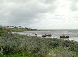 View of Emu Bay and jetty from the picnic area. | |||||||||||||
 Emu Bay | |||||||||||||
| Coordinates | 35°35′26″S 137°30′13″E / 35.59067069°S 137.50374797°ECoordinates: 35°35′26″S 137°30′13″E / 35.59067069°S 137.50374797°E | ||||||||||||
| Population | 2034 (shared with other localities in the “State Suburb of Kingscote”) (2011 census)[1][lower-alpha 1] | ||||||||||||
| Established | 1882[2] | ||||||||||||
| Postcode(s) | 5223 [3] | ||||||||||||
| Time zone | ACST (UTC+9:30) | ||||||||||||
| • Summer (DST) | ACST (UTC+10:30) | ||||||||||||
| Location |
| ||||||||||||
| LGA(s) | Kangaroo Island Council[2] | ||||||||||||
| State electorate(s) | Finniss[4] | ||||||||||||
| Federal Division(s) | Mayo[5] | ||||||||||||
| |||||||||||||
| |||||||||||||
| Footnotes |
Coordinates[2] Locations[3] Climate[6] Adjoining localities[2] | ||||||||||||
Emu Bay (known as Maxwell from 1882 to 1941) is a locality in the Australian state of South Australia on the north coast of Kangaroo Island about 13 kilometres (8.1 mi) west of the island's main town, Kingscote.[2]
It is a small town of 97 allotments[7] with an even mix of permanent and holiday homes. The town has no shops or mains water supply. Emu Bay is known as a popular swimming beach, and is one of few on Kangaroo Island where vehicles are permitted.
A small jetty dates to 1918. Originally 109 metres (358 ft) long, it allowed ketches such as Karatta to tie up to load cargoes, while a nearby fresh water well serviced horses which pulled wagons down to the bay.[8] Until the 1930s, grain, stock and merchandise were taken to and from Kangaroo Island from this jetty.[9]
Emu Bay is also the location of an unusual geological formation named Emu Bay shale.
The coastline from Cape D'Estaing at the west end of the bay known as Emu Bay to Point Marsden in the locality of North Cape in the east is listed on the South Australian Heritage Register as a site of “geological and outstanding palaeontological significance.” [10]
Emu Bay is located within the federal division of Mayo, the state electoral district of Finniss and the local government area of the Kangaroo Island Council.[5][4][2]
References
- Notes
- ↑ For the 2011 census, the “State Suburb of Kingscote” consisted of the localities of Bay of Shoals, Emu Bay, Kingscote, North Cape and Wisanger.
- Citations
- ↑ Australian Bureau of Statistics (31 October 2012). "Kingscote". 2011 Census QuickStats. Retrieved 22 April 2016.
- 1 2 3 4 5 6 "Search result for "Emu Bay(Locality Bounded)" (Record no SA0022502) with the following layers selected - "Suburbs and Localities" and "Place names (gazetteer)"". Department of Planning, Transport and Infrastructure. Retrieved 22 April 2016.
- 1 2 "Postcode for Emu Bay, South Australia (Postcode)". postcodes-australia.com. Retrieved 22 April 2016.
- 1 2 "District of Finniss Background Profile". Electoral Commission SA. Retrieved 2 August 2015.
- 1 2 "Federal electoral division of Mayo, boundary gazetted 16 December 2011" (PDF). Australian Electoral Commission. Retrieved 2 August 2015.
- ↑ "Monthly climate statistics: Summary statistics KINGSCOTE (nearest station)". Commonwealth of Australia , Bureau of Meteorology. Retrieved 20 April 2016.
- ↑ Government Township maps, Lands Titles Office, Adelaide
- ↑ State Library of South Australia. "Emu Bay Jetty". Retrieved 2007-07-09.
- ↑ SA Central. "Kangaroo Island Beaches". Retrieved 2007-07-12.
- ↑ "Cape d'Estaing to Emu Bay (west) and Emu Bay (east) to Boxing Bay Coastline (designated place of palaeontological significance)". South Australian Heritage Register. Department of Environment, Water and Natural Resources. Retrieved 2 June 2016.
Gallery

| Major townships | |||||||||||||||
|---|---|---|---|---|---|---|---|---|---|---|---|---|---|---|---|
| Beaches | |||||||||||||||
| Coastal features |
| ||||||||||||||
| Protected areas |
| ||||||||||||||
| Islands adjacent to Kangaroo Island coast | |||||||||||||||
| Related and uncategorised | |||||||||||||||
| |||||||||||||||