Redhead, New South Wales
| Redhead New South Wales | |||||||||||||
|---|---|---|---|---|---|---|---|---|---|---|---|---|---|
| Population | 3,453 (2011 census)[1] | ||||||||||||
| • Density | 639/km2 (1,656/sq mi) | ||||||||||||
| Established | 1829 | ||||||||||||
| Postcode(s) | 2290 | ||||||||||||
| Area | 5.4 km2 (2.1 sq mi) | ||||||||||||
| Location |
| ||||||||||||
| LGA(s) | City of Lake Macquarie | ||||||||||||
| Parish | Kahibah | ||||||||||||
| State electorate(s) | |||||||||||||
| Federal Division(s) | Shortland | ||||||||||||
| |||||||||||||
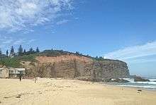
Redhead is a coastal suburb of the City of Lake Macquarie in New South Wales, Australia 16 kilometres (10 mi) south of Newcastle's central business district on the Pacific Ocean. It was named for the appearance of its headland when viewed from the sea. It has a population of 3,453 an increase on the 3,336 recorded in 2006.
History
Early industries included a banana orchard and mining. A mine explosion killed five people in 1926. The suburb was developed in the late 1940s. The first school opened in 1908.
The railway line that connected Redhead with Newcastle and Belmont was closed 1971. It was converted to a popular walking and cycling path called the Fernleigh Track. It was opened in 2009.
The suburb is best known for its beach which is a popular surfing location in Newcastle.
Over the past few years the suburb has been plagued by a number of fires, including in 2013.
References
- ↑ Australian Bureau of Statistics (31 October 2012). "State Suburbs: Redhead". 2011 Census QuickStats. Retrieved 25 July 2014.
External links
- History of Redhead (Lake Macquarie City Library)
Coordinates: 33°00′36″S 151°43′23″E / 33.010°S 151.723°E