Wangi Wangi, New South Wales
| Wangi Wangi New South Wales | |||||||||||||
|---|---|---|---|---|---|---|---|---|---|---|---|---|---|
 | |||||||||||||
| Coordinates | 33°03′54″S 151°34′05″E / 33.065°S 151.568°ECoordinates: 33°03′54″S 151°34′05″E / 33.065°S 151.568°E | ||||||||||||
| Population | 2,670 (2011 census)[1] | ||||||||||||
| Postcode(s) | 2267 | ||||||||||||
| Location | 16 km (10 mi) ENE of Morisset | ||||||||||||
| LGA(s) | City of Lake Macquarie | ||||||||||||
| Parish | Awaba | ||||||||||||
| State electorate(s) | Lake Macquarie | ||||||||||||
| Federal Division(s) | Charlton | ||||||||||||
| |||||||||||||
Wangi Wangi (/ˈwɒndʒi wɒndʒi/ WON-jee-won-jee) is a suburb of the City of Lake Macquarie in New South Wales, Australia, which forms a peninsula jutting eastwards into Lake Macquarie. Wangi Wangi is a well known holiday spot, that was frequented in the early days by families from the coalfields. It is known for its beautiful views, bush-walking, and fishing spots. Early travel to the peninsula was quite difficult, and it was only accessible by ferries. Among the ferries operating to allow travel to Wangi were the Wangi Wangi, the Azile and the first Wangi Queen .
The Wangi Queen currently on Sydney Harbour started out as a double decker built in 1922 as the Ettalong for use at Ettalong, and subsequently renamed Profound, and renamed in 1975 as the second "Wangi Queen" for use Lake Macquarie,where it remained until 2012.
Wangi is also well known as the former home of artist William Dobell.
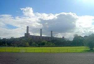
The suburb is also home to the retired Wangi Power Station, which operated from 1956 to 1986. Pulbah Island lies to the south of the peninsula.
Wangi Wangi also has its own Rugby League team over the years being the Wangi Warriors. There are also a number of bushwalking tracks around the bushland. Some of which are host to gun emplacements, stationed during the course of World War II. Wangi Wangi and its people : a local history was published in 1987. The name Wangi Wangi is aboriginal for either Water Water, many night owls or many trees.
See also
References
- ↑ Australian Bureau of Statistics (31 October 2012). "Wangi Wangi (State Suburb)". 2011 Census QuickStats. Retrieved 16 February 2014.
External links
- History of Wangi Wangi (Lake Macquarie City Library)
- Travel guide to Wangi Wangi Sydney Morning Herald
- Wangi Wangi - Culture and History (The Age)
- Dobell House Museum - Home of Sir William Dobell
- Wangi Wangi RSL
- Gun Emplacement Bunker Picture
- Wangi Wangi Junior Rugby League Football Club
- Wangi Wangi Netball Club
- Wangi Hotel Cricket team