Rife Farmstead
|
Rife Farmstead | |
 | |
  | |
| Location | Osage Mills Rd., Osage Mills, Arkansas |
|---|---|
| Coordinates | 36°16′10″N 94°15′57″W / 36.26944°N 94.26583°WCoordinates: 36°16′10″N 94°15′57″W / 36.26944°N 94.26583°W |
| Area | 1.5 acres (0.61 ha) |
| Built | 1910 |
| Architectural style | Bungalow/craftsman |
| MPS | Benton County MRA |
| NRHP Reference # | 87002380[1] |
| Added to NRHP | January 28, 1988 |
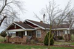
The Rife Farmstead is a historic farm property in rural Benton County, Arkansas. Located on the west side of County Road 47 about 1.25 miles (2.01 km) north of its junction with Arkansas Highway 264, it consists of a single-story Bungalow-style stone house with a front-gable roof, and a side gable projecting portico. The house was built in 1928 by Luther Rife, and is unusual in this rural setting, where most houses are vernacular in form. The property original had two c. 1910 barns when the property was surveyed in 1988;[2] these are apparently no longer standing.
The property was listed on the National Register of Historic Places in 1988.[1]
See also
References
- 1 2 National Park Service (2010-07-09). "National Register Information System". National Register of Historic Places. National Park Service.
- ↑ "NRHP nomination for Rife Farmstead" (PDF). Arkansas Preservation. Retrieved 2015-03-05.
| Topics | |
|---|---|
| Lists by states |
|
| Lists by insular areas | |
| Lists by associated states | |
| Other areas | |
| |
This article is issued from Wikipedia - version of the 12/1/2016. The text is available under the Creative Commons Attribution/Share Alike but additional terms may apply for the media files.