River Loddon
| Loddon | |
| River | |
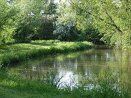 River Loddon near Stratfield Saye | |
| Country | England |
|---|---|
| Counties | Hampshire, Berkshire |
| Tributaries | |
| - left | River Blackwater, Emm Brook, River Broadwater, St Patrick's Stream |
| Towns | Basingstoke, Earley, Woodley, Twyford |
| Landmarks | Basing House, Stratfield Saye House, Basingstoke Canal |
| Source | |
| - location | Basingstoke, Hampshire, United Kingdom |
| - elevation | 100 m (328 ft) |
| - coordinates | 51°15′53″N 1°06′57″W / 51.264614°N 1.115713°W |
| Mouth | River Thames |
| - location | Wargrave, Berkshire, United Kingdom |
| - elevation | 33 m (108 ft) |
| - coordinates | 51°30′06″N 0°52′48″W / 51.50169°N 0.880001°WCoordinates: 51°30′06″N 0°52′48″W / 51.50169°N 0.880001°W |
| Length | 45 km (28 mi) |
| Basin | 1,036 km2 (400 sq mi) |
| Discharge | for Sheepbridge |
| - average | 2.16 m3/s (76 cu ft/s) |
| - max | 26.4 m3/s (932 cu ft/s) 16 September 1986 |
| - min | 0.52 m3/s (18 cu ft/s) 26 August 1976 |
River Loddon | |||||||||||||||||||||||||||||||||||||||||||||||||||||||||||||||||||||||||||||||||||||||||||||||||||||||||||||||||||||||||||||||||||||||||||||||||||||||||||||||||||||||||||||||||||||||||||||||||||||||||||||||||||||||||||||||||||||||||||||||||||||||||||||||||||||||||||||||||||||||||||||||||||||||||||||||||||||||||||||||||||||||||||||||||||||||||||||||||||||||||||||||||||||||||||||||||||||||||||||||||||||||||||||||||||||||||||||||||||||||||||||||||||||||||||||||||
|---|---|---|---|---|---|---|---|---|---|---|---|---|---|---|---|---|---|---|---|---|---|---|---|---|---|---|---|---|---|---|---|---|---|---|---|---|---|---|---|---|---|---|---|---|---|---|---|---|---|---|---|---|---|---|---|---|---|---|---|---|---|---|---|---|---|---|---|---|---|---|---|---|---|---|---|---|---|---|---|---|---|---|---|---|---|---|---|---|---|---|---|---|---|---|---|---|---|---|---|---|---|---|---|---|---|---|---|---|---|---|---|---|---|---|---|---|---|---|---|---|---|---|---|---|---|---|---|---|---|---|---|---|---|---|---|---|---|---|---|---|---|---|---|---|---|---|---|---|---|---|---|---|---|---|---|---|---|---|---|---|---|---|---|---|---|---|---|---|---|---|---|---|---|---|---|---|---|---|---|---|---|---|---|---|---|---|---|---|---|---|---|---|---|---|---|---|---|---|---|---|---|---|---|---|---|---|---|---|---|---|---|---|---|---|---|---|---|---|---|---|---|---|---|---|---|---|---|---|---|---|---|---|---|---|---|---|---|---|---|---|---|---|---|---|---|---|---|---|---|---|---|---|---|---|---|---|---|---|---|---|---|---|---|---|---|---|---|---|---|---|---|---|---|---|---|---|---|---|---|---|---|---|---|---|---|---|---|---|---|---|---|---|---|---|---|---|---|---|---|---|---|---|---|---|---|---|---|---|---|---|---|---|---|---|---|---|---|---|---|---|---|---|---|---|---|---|---|---|---|---|---|---|---|---|---|---|---|---|---|---|---|---|---|---|---|---|---|---|---|---|---|---|---|---|---|---|---|---|---|---|---|---|---|---|---|---|---|---|---|---|---|---|---|---|---|---|---|---|---|---|---|---|---|---|---|---|---|---|---|---|---|---|---|---|---|---|---|---|---|---|---|---|---|---|---|---|---|---|---|---|---|---|---|---|---|---|---|---|---|---|---|---|---|---|---|---|---|---|---|---|---|---|---|---|---|---|---|---|---|---|---|---|---|---|---|---|---|---|---|---|---|---|---|---|---|---|---|---|---|---|---|---|---|---|---|
Legend
| |||||||||||||||||||||||||||||||||||||||||||||||||||||||||||||||||||||||||||||||||||||||||||||||||||||||||||||||||||||||||||||||||||||||||||||||||||||||||||||||||||||||||||||||||||||||||||||||||||||||||||||||||||||||||||||||||||||||||||||||||||||||||||||||||||||||||||||||||||||||||||||||||||||||||||||||||||||||||||||||||||||||||||||||||||||||||||||||||||||||||||||||||||||||||||||||||||||||||||||||||||||||||||||||||||||||||||||||||||||||||||||||||||||||||||||||||
The River Loddon is a river in the English counties of Berkshire and Hampshire. It is a tributary of the River Thames, rising within the urban area of Basingstoke and flowing to meet the Thames near the village of Wargrave. The river has a total length of 28 miles (45 km) and, together with its tributaries, drains an area of 400 square miles (1,036 km2).[1]
Historically, the river has been important for milling, and the channel has been modified by the creation of mill ponds, weirs and sluices. Most of the mills used water wheels to generate their power, although two used water turbines. One was a silk mill for a short period, and one was a paper mill, with the rest milling corn or producing flour. Several have been converted to become homes or hotels, but one is still operated on an occasional basis. The river has been used for navigation in the past, although its exact nature is unclear.
The river is an important resource for wild life. Former gravel workings have become Loddon Nature Reserve and Dinton Pastures Country Park. A section of it is a designated Site of Special Scientific Interest due to rare populations of bulbs and pondweed. It supports several species of fish, and recent improvements have included the provision of a fish bypass, to enable migrating fish to move around the mill site at Arborfield. The scheme has been implemented to comply with the Water Framework Directive and is expected to be a benchmark for similar schemes on other rivers. The river first becomes into a full scale river in the village of old basing, it is free to fish here as long as you dont fish on private land, this includes, the part of the river near the over head railway bridge and on wards to the road bridge into the the woods lots of fish and good fun. You can also fish on wards towards where the river splits.
Course
The River Loddon rises at West Ham Farm in Basingstoke, and in its first mile flows under the Festival Place shopping centre that forms the main part of the central area of that town; the adjacent bus station sits on the site of the wharf at the start of the Basingstoke Canal. The river emerges again in Eastrop Park, where it now runs alongside and just below Eastrop Way which follows the course of the disused canal. Eastrop Park was the site of Basingstoke Corn Mill in 1873,[2] but by 1932 it was called Vince's Farm, although the buildings still spanned the river.[3] The river then passes through some water meadows where it is joined by small streams from springs and ponds at Black Dam. The flow from these previously had to pass under a wide bend of an embankment which held the Basingstoke Canal. Basingstoke Upper Mill was to the south of the embankment. Again it was a corn mill in 1873,[2] but just a farm in 1932.[3] The area near where the streams meet was a peat moor, and parts of it were used for growing watercress.[4] The Basingstoke Union Workhouse was on the north bank.[2] It later became a hospital[4] and is now the site of a private hospital. The river then flows close by the village of Old Basing and the ruins of Basing House.[5] It is crossed by a brick-built railway viaduct, with four arches,[6] which carries the Southern Railway line to Basingstoke railway station. Just beyond it was Old Basing Mill, still marked as a corn mill in 1932[3] but now called Barton's Mill. There were more watercress beds to the north of the mill.[3] Pyotts Hill and The Street meet at a narrow bridge over the river, which is built of brick and has three arches. Funding to construct it was obtained by public subscription, and it was opened in 1826.[6]
Immediately below the bridge, the river widens, as it formed a reservoir for the Lower Mill, a corn mill in 1872,[7] but disused by 1932.[3] Leaving the environs of Basingstoke behind, the river flows north through open north Hampshire countryside. There are two channels, the Upper River to the north and the Lower River to the south. There are various interconnections and tributary streams, before the Lyde River joins it just above the village of Sherfield on Loddon. Hartley Mill was on the Lyde just above the confluence, but was disused by 1968.[8] At Sherfield, Longbridge Mill is just above Long Bridge, which carries the A33 road over the river and a backwater. North of Sherfield the river passes the site of Lilly Mill and crosses under Broadford Bridge, before passing through the ornamental grounds of Stratfield Saye House, the home of the Dukes of Wellington since 1817. Within the park is a cast iron grade II* listed bridge designed by Thomas Wilson in 1802.[9] Stanfordend Bridge is to the north of the park, and is grade II listed. It has two small arches separated by buttresses, and bears the date 1787.[10] Stanfordend Flour Mill was just beyond it, but it was disused by 1961.[4]
Entering Berkshire, the river passes through the embankment of the A33 road, which bypasses the village of Swallowfield, and then under King's Bridge, which carries a minor road. The B3349 from Swallowfield crosses next, near the weirs of Sheepbridge Mill, which was a corn mill in 1872 [7] but had become a hotel by 1968.[8] Just north of Swallowfield the River Loddon is joined by the River Blackwater which adds substantially to its flow. The A327 road crosses at Arborfield Bridge, beyond which was Arborfield Paper Mill, close to the ruins of St Bartholomews Church, already ruined in 1873,[2] while the mill was disused by 1899.[11] Next comes the M4 motorway bridge, and the much smaller bridge carrying Mill Lane over the river by Sindlesham Mill, once a flour mill but now a hotel. The river flows close to the east of the Berkshire suburbs of Earley and Woodley, and is crossed by two road bridges and a railway bridge to the west of Winnersh, before it reaches Dinton Pastures Country Park.[12]
The third of the three bridges carried the A329(M) road, now downgraded to the A3290, and was subject to a catastrophic failure during construction in 1972. The formwork which should have supported the concrete while it was being poured collapsed. Three men died and ten were injured in the wreckage. The Bragg report subsequently considered why the accident had happened and made recommendations as to how formwork should be designed and tested, to make bridge construction safer.[13] Around 500 tons of concrete, with the steelwork and planking that should have supported it, dropped 40 feet (12 m) into the river. It was the eighth span of a total of 33 which make up the viaduct.[14]
Shortly after Dinton Pastures is Sandford Mill, a corn mill in 1873[2] which was disused by the 1960s.[15] Near the village of Hurst the river is joined by the Emm Brook. It then splits into two channels, the western one labelled "Old River" on modern maps, although both have followed their present course since at least 1873.[2] Several large lakes indicate where sand and gravel have been extracted, and after both channels are crossed by the railway line from Paddington to Reading, further lakes have become the Loddon Nature Reserve. The river then flows close to the village of Twyford, passing the site of Twyford Flour Mill, after which it is crossed by the A3032 and A4 road bridges, and is joined by St Patrick's Stream, a backwater of the River Thames. About a mile further on it flows into the main channel of the Thames, just downstream of Shiplake Lock and close to the village of Wargrave.[12]
Hydrology
Whilst chalk underlies much of the River Loddon's catchment area, it only appears at the surface at either end of the river, near Wargrave and Basingstoke. For the rest of its course the chalk lies beneath the Reading Beds and London Clay. The terrace gravels of the Loddon valley have been extracted in a number of places, including the lakes within Dinton Pastures Country Park.[1]
The catchment area of the River Loddon has large or dense population centres in Basingstoke and eastern Reading, plus the urban areas of Aldershot, Fleet, Camberley and Farnborough in that of the tributary River Blackwater. As a consequence the Loddon receives treated sewage effluent of nine plants, one just downstream of Basingstoke, a second at Wargrave, and seven along the Blackwater.[1]
Flora and fauna
The River Loddon has an identifiable array of fish, differing from that of the mainstream Thames in Berkshire including shoals of bream, chub, roach, rudd and large barbel. The record for the largest barbel caught on the river stands at 18 lb 1 oz (8.19 kg). It was caught in 2008. Other records include a 17 lb 12 oz (8.05 kg) pike caught in 1995 and a 17 lb 8 oz (7.94 kg) carp caught in 2002.[16]
A 2.5-mile (4.0 km) stretch of the Loddon near Stanfordend Mill, together with the adjacent hay meadows, which are periodically waterlogged, is a designated Site of Special Scientific Interest (SSSI). The Loddon has been part of the SSSI since 1986. The meadows are cut for hay in July each year, and then grazed by cattle until the end of the year. This cycle has resulted in a large population of fritillaries (Fritillaria meleagris), a bulb which thrives in damp meadows when its life cycle is not cut short by more modern management regimes. The river is included for its population of Loddon pondweed (Potamogeton nodosus), as this is the principal location in the country where it can be found.[17]
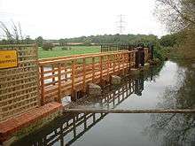
In an effort to improve conditions for migrating fish, a £485,000 scheme to create a 220-yard (200 m) bypass around the weirs at Arborfield was implemented in 2010. It was a joint project between the Environment Agency, Thames Water, the University of Reading, the Farley Estate and Arborfield Angling Society, created to meet the provisions of the Water Framework Directive. The channel provides a range of habitats, including a 88-yard (80 m) stretch which is suitable for spawning fish to lay their eggs, and is expected to be of benefit to salmon, sea trout, eels and barbel. The first phase of the project, which involved repairs to four of the five weir structures at Arborfield, was designed to create lower water levels on the 2.8-mile (4.5 km) section above the mill site, to reduce the risk of flooding. Cain Bio-Engineering carried out the construction work, and the project is expected to become a benchmark for such schemes.[18]
Milling
The river has provided the power for a number of water mills along its course. At Twyford, there have been mills since at least 1365, and a silk mill was built in 1810.[19] Silk worms thrive on mulberry trees, and Queen Elizabeth I had encouraged planting of them during her reign. The Wokingham area was known for its production of silk stockings, and Thomas and George Billing, who were from Macclesfield and were brothers, hoped to create a profitable business processing the silk. The spun silk was woven on looms set up in cottages, and for a while the Billings were reasonably successful, although labour costs were kept down by employing children who should have been at Polehampton School. The law changed to allow silk to be imported more freely from France, and only mills equipped with up-to-date equipment could compete. Thomas died in 1824, and the mill was sold to become a flour mill soon afterwards.[20] The wooden building was burnt down in a fire in 1891. A new mill was built, and in 1927 was bought by Berks, Bucks and Oxon Farmers Ltd, a group of farmers who operated as a co-operative to mill animal feed.[21] The mill was powered by water wheels and diesel engines until the early 1960s, when it was converted to use electric motors. A distribution warehouse was added in 1969,[22] but another fire destroyed the building in 1976, and construction of a new mill was completed in 1979.[19] The owners became bankrupt[23] in the 1990s, and in 2001 the site was redeveloped for housing.[21] Although none of it is original, much of the building has four storeys, as did the pre-1976 building, and incorporates cosmetic features to suggest the previous use of the site.
Sandford Mill was used for milling feed for animals until the 1950s, and was powered by two waterwheels. It is known to have existed during the English Civil War, as it was mentioned in reports. Following a period of disuse, it has been converted into a residence. The main structure of Sindlesham Mill dates from the late 1800s, but it may incorporate part of an earlier structure, as some of the timbers are much older than that. It used a turbine rather than a water wheel to generate its power, and was owned by the Reading-based Simmonds family, who were involved in banking and brewing. Later, it was acquired by Garfield Weston, and produced flour for the biscuit manufacturer Huntley & Palmers until the 1960s. It is now part of a hotel complex.[23]
Milling had been performed at Arborfield since at least 1500, as foundations dating to that time were discovered in 1953. The mill was originally a grist mill, used for grinding corn or flour, but George Dawson converted it to a paper mill. A Mr. Hodgson was the paper maker in 1787, and in 1794 the business was auctioned as a going concern. In 1826, the large water wheel powered a 48-inch (120 cm) paper making machine. Three years later there was a fire at the mill, and another in 1861. Output from the mill included fine brown paper. Mrs Hargreaves, the owner of Arborfield Hall, is thought to have demolished part of the mill some time after 1861, but it was offered for sale again in 1919, and at the time included a 40-horsepower (30 kW) water wheel and a 28-horsepower (21 kW) turbine. Pumps and a dynamo supplied water and electricity to the hall, and powered the machinery on the farm. In the 1840s or 1850s, an engine house was built near the mill, which housed a Barrett, Exall & Andrews steam engine, which was manufactured in Reading. Two steam engines later powered the paper mill. The mill was owned by Guthrie Allsebrook from the 1920s, who hoped to supply water to the local authority, because he also owned the water rights. The ground floor of the building still exists, and was in use by Thames Water in 2004.[24]
Records show that milling was taking place near Sherfield on Loddon in 1274, when the miller was called John. There is also reference to a water mill in 1316, and a document recording holdings passed to the Manor in 1601 listed two water mills, a fulling mill and another mill. By 1819, there were two water wheels at the Longbridge mill, which powered four pairs of grinding wheels. By the end of the Second World War, the mill was producing animal feed, and continued to use water power until 1950. Commercial operation of the mill ceased in 1977, and it was damaged by fire in 1991. Restoration of the damaged building began soon afterwards, and was completed in 1997. Since then the mill has been operated on an occasional basis by the Hampshire Mills Group, and is used to grind flour on open days.[25] The building dates from the seventeenth and early nineteenth centuries, and is a listed building.[26]
The mill at Stanfordend, to the north of Stratfield Saye Park, has been disused since the 1930s. Power was generated by the use of three turbines, rather than a water wheel. It is owned by the Duke of Wellington's estate, who had plans in 2000 to restore it to working condition. Hartley Mill, on the Lyde just above its junction with the Loddon, is now a residence, but the water wheel has been retained, and can be seen from the dining room.[23] The Lower Mill at Old Basing is a four-storey building dating from the later eighteenth and early nineteenth centuries, and is grade II listed.[27] Old Basing mill is another four-storey building, which still contained much of the original machinery in 2000, although it is not operational.[23]
Navigation
It seems likely that the Loddon was used for navigation in the past, although the details are not clear. There is circumstantial evidence in the naming of Barge Lane, which runs beside the river at Swallowfield, and of some of the pools by the mills. The pools at Arborfield Mill and Sindlesham Mill are both called Lock Pool. More concrete evidence is provided by the number of boat houses marked on old maps, including two on the Arborfield estate, one of which still exists, one near Mill Lane at Sindlesham, and another at Woodley, near to Colmansmoor Lane. Other evidence includes postcards in the collection at Reading Local Studies Library, which show a punt at Twyford and rowing boats at Sindlesham Mill and Arborfield Hall. Old postcards also show that The George public house at Winnersh used to have rowing boats on the river available for hire.[28] There was a boathouse on the opposite bank to the public house, one of eleven on the river around the 1900s.[29]
Lady Constance Russell, writing in 1901 recorded that Sir Henry Russell, who owned Swallowfield Park and died in 1852, spent his latter years improving his property, and this included filling in the canal which "ran from the Lock Pool near the church to the Bow Bridge".[30] The canal is clearly shown on a map produced in 1790 by Thomas Pride, and on an Enclosure Map for Swallowfield, produced in 1817 and held at the Berkshire Record Office.[28] Further evidence for the use of the river was the death of John Alfred Dymott in 1917, who drowned after falling out of a punt which he was using to transport materials. He often performed such duties, and in this case had been assisting the estate carpenter to erect fencing near the river and remove timber from it.[31]
Points of interest
See also
Bibliography
- ALHS. "The River Loddon: A Navigable Waterway?". Arborfield Local Historical Society.
- Eighteen, Brian (2000). "Watermills on the River Loddon". Wargrave Local History Society. Retrieved 2012-01-04.
- Fitch, John (1989). Twyford and Ruscombe Village Walks. Twyford and Ruscombe Local History Society. ISBN 0-948245-05-0.
- Russell, Lady Constance (1901). Swallowfield and its Owners (PDF). Longman.
References
- 1 2 3 "The River Loddon and the Emm Brook". Wokingham District Council. Archived from the original on February 28, 2006. Retrieved March 30, 2006.
- 1 2 3 4 5 6 Ordnance Survey, 1:2500 map, 1873
- 1 2 3 4 5 Ordnance Survey, 1:2500 map, 1932
- 1 2 3 Ordnance Survey, 1:10,560 map, 1961
- ↑ Explorer Map 144 - Basingstoke, Alton & Whitchurch. Ordnance Survey (2005). ISBN 0-319-23606-4.
- 1 2 "Vol 2: Basingstoke and Dearne". Hampshire Treasures. Retrieved 2012-01-02.
- 1 2 Ordnance Survey, 1:2500 map, 1872
- 1 2 Ordnance Survey, 1:2500 map, 1968-1976
- ↑ Historic England. "Bridge, Stratfield Saye Park (139118)". Images of England.
- ↑ Historic England. "Stanfordend Bridge (41583)". Images of England.
- ↑ Ordnance Survey, 1:2500 map, 1899
- 1 2 Explorer Map 159 - Reading. Ordnance Survey (2006). ISBN 0-319-23730-3.
- ↑ "Design Failures" (PDF). Wiley. pp. 6, 13. Retrieved 2012-01-02.
- ↑ "Digging for dear life". Wokingham Times. 26 October 1972. Retrieved 2012-01-02.
- ↑ Ordnance Survey, 1:2500 map, 1960-1969
- ↑ "Fishing on the River Loddon". Wokingham Borough Council. Retrieved 2012-01-03.
- ↑ "Stanfordend Mill and River Loddon SSSI" (PDF). English Nature. 1987. Retrieved 2012-01-04.
- ↑ "River Loddon Case Study:Mill Leat Bypass". Cain Bio Engineering. Retrieved 2012-01-04.
- 1 2 Fitch 1989, p. 12
- ↑ "Commerce". The CD_Rom of Hurst. Retrieved 2012-01-02.
- 1 2 "Twyford". The CD_Rom of Hurst. Retrieved 2012-01-02.
- ↑ "Berks, Bucks and Oxon Farmers Ltd". Archives Hub. Retrieved 2012-01-04.
- 1 2 3 4 Eighteen 2000
- ↑ "Properties - The Mill". Arborfield Local History Society. Retrieved 2012-01-03.
- ↑ "Longbridge Mill". Hampshire Mills Group. Retrieved 2012-01-03.
- ↑ Historic England. "Longbridge Mill, Sherfield on Loddon (139027)". Images of England.
- ↑ Historic England. "Lower Mill, Newnham Road, Old Basing (138904)". Images of England.
- 1 2 ALHS
- ↑ Ordnance Survey, 1:2500 maps, 1872 and 1912
- ↑ Russell 1901, p. 269
- ↑ "Inquest on butler at Arborfield Hall". Reading Mercury (online copy by ALHS). 19 May 1917.
External links
| Wikimedia Commons has media related to River Loddon. |
| Next confluence upstream | River Thames | Next confluence downstream |
| Berry Brook (north) | River Loddon | Hennerton Backwater |
| Main rivers |
|  |
|---|---|---|
| Canals and Navigations | ||
| Ordinary watercourses |
| |
| Lakes, ponds and wetlands | ||
| Coast | ||
Categories: Rivers, Canals | ||