Lake Roland (park)
|
Lake Roland Historic District | |
   | |
| Nearest city | Robert E. Lee Memorial Park, Baltimore, Maryland |
|---|---|
| Coordinates | 39°23′13″N 76°38′49″W / 39.38694°N 76.64694°WCoordinates: 39°23′13″N 76°38′49″W / 39.38694°N 76.64694°W |
| Area | 281 acres (114 ha) |
| Built | 1858 |
| Architect | Slade, James |
| Architectural style | Greek Revival |
| NRHP Reference # | 92001285[1] |
| Added to NRHP | October 15, 1992 |
Lake Roland Park (Formerly named "Robert E. Lee Park") is a city/county park encompassing 415 acres [2] of woodland, wetlands, serpentine barrens, rare plants and rocky plateaus surrounding Lake Roland in Baltimore County, Maryland, located near the intersection of Falls Road and Lake Avenue, adjacent to the Falls Road Light Rail Stop of the Baltimore Light Rail, which runs from Cromwell Station near Glen Burnie in Anne Arundel County in the south to Hunt Valley of Baltimore County. The line runs along a railroad embankment and trestle over the lake above the dam, cutting the park into a two-thirds wooded northern part and the one-third southern portion around the dam, picnic groves, pavilion and pumping station.
Though the park is located just outside the northern limits of Baltimore city, it is owned by the city and operated as a park since the 1920s by the Baltimore City Department of Recreation and Parks and after a decades-long controversy is now leased to neighboring Baltimore County and operated by their parks agency, in a similar arrangement to the situation with Fort Smallwood Park, several miles southeast of the city along the Patapsco River's south shore in Anne Arundel County, and transferred for lease to that suburban county's jurisdiction. The park was temporarily closed in 2009 for extensive renovations under the new Baltimore County administration and reopened to the public on Friday, October 14, 2011.
History
The lake was constructed in the late 1850s after the city's 1854 purchase of the assets of the privately owned Baltimore Water Company, (founded 1805), following a long political controversy about the company's failure to extend water lines and service into the then outlying areas of town after the most recent annexation of 1818 which moved the city's northern boundary to then-called Boundary Avenue (today's North Avenue). The "Beaver Dam" marble old pumping station on the eastern shore of the lake contains a marble pedestal engraved with the dates and names of the pertinent officials and contractors involved in its construction and completion in 1860–61, along with another stone tablet that used to lie at the dam's western end before its reconstruction in the mid-1990s by the city.
Further to the south, the city had also just purchased the former Lloyd Nicholas Rogers estate "Druid Hill", first settled in the mid-1660s and with manor plantation houses reconstructed several times since, most recently in 1800 with what later became called the "Mansion House". It formed the third largest municipal landscaped park in the country (after Central Park in New York City and Fairmount Park in Philadelphia). Druid Lake was carved out, constructed and landscaped to add capacity to the newly expanded first municipal water supply system using the waters of the inter-connecting Jones Falls which flowed south through the central city to the Northwest Branch of the Patapsco River and the Baltimore Harbor. The system of parks for the City of Baltimore along the various stream valleys with inter-connected landscaped boulevards or parkways was designed and laid out by the famous landscape architect and developer Frederick Law Olmsted and the company later established by his sons in two famous reports in 1904 and 1926, of which Lake Roland and its Dam formed and integral part.
Lake Roland Historic District is a national historic district in Baltimore City and Baltimore County, Maryland, United States. It consists of a man-made lake, Lake Roland, portions of the Jones Falls and Roland Run streambeds, and portions of the rights-of-way of former Green Spring Valley Railroad and the Northern Central Railway. The central portion of the historic district is occupied by Lake Roland, with a stone dam capped by a stone valve house, built in 1858-1861. The lake was developed in the mid 19th century as a part of the city's municipal water system and built as the main reservoir. The lake is surrounded by open areas and woods.[3]
Name
In 1917, the park was designated as Robert E. Lee Memorial Park after General Robert E. Lee, who commanded the Confederate Army of Northern Virginia during the American Civil War. This was done at the request of a wealthy Baltimorean, who required that when she died, the proceeds from the sale of her estate was to be used to erect a monument for Lee.[4]
Due to reactions to the 2015 Charleston church shooting as well as the general controversy revolving the display of Confederate symbols, the government of Baltimore County renamed the park to Lake Roland[4][5] on September 28, 2015. The City of Baltimore, the park's official owner, has a bill in place to change the official name to Lake Roland Park as well.[6]
Gallery
-
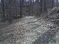
A walking trail at Lake Roland
-
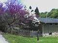
A house inside of Lake Roland
-

Lake Roland
-
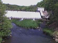
The dam and Greek Revival-style marble pumping station (to the right/east) where Lake Roland flows into the Jones Falls
See also
References
- ↑ National Park Service (2010-07-09). "National Register Information System". National Register of Historic Places. National Park Service.
- ↑ http://www.baltimorecountymd.gov/Agencies/recreation/programdivision/naturearea/relpark/index.htm
- ↑ Ward Bucher and Susan Cook (June 1991). "National Register of Historic Places Registration: Lake Roland Historic District" (PDF). Maryland Historical Trust. Retrieved 2016-03-01.
- 1 2 Perl, Larry (28 September 2015). "Baltimore County renaming Robert E. Lee Park as Lake Roland". Baltimore Sun. Retrieved 3 October 2015.
- ↑ (22 June 2015). "Erasing Robert E Lee". TV-Novosti. Retrieved February 6, 2016.
- ↑ Wenger, Yvonne (17 July 2015). "City legislation would rename Robert E. Lee Park". Retrieved 4 October 2015.
External links
- Lake Roland on Google Street View
- Lake Roland - Baltimore County
- Lake Roland Historic District, Baltimore City, including photo from 1986, at Maryland Historical Trust, and accompanying map
| Topics |   | |
|---|---|---|
| Lists by county | ||
| Lists by city | ||
| Other lists | ||
| ||