Romney Marsh
| Romney Marsh | |
|---|---|
|
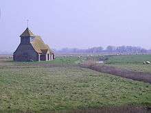
St Mary in the Marsh in Romney Marsh | |
 Romney Marsh | |
| OS grid reference | TR053224 |
| Coordinates | 50°57′51″N 0°55′29″E / 50.96417°N 0.92463°E |
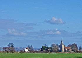
Romney Marsh is a sparsely populated wetland area in the counties of Kent and East Sussex in the south-east of England. It covers about 100 square miles (260 km2).
Governance
An electoral ward in the same name exists. This ward had a population of 2,358 at the 2011 census.[1]
Quotations
- “As Egypt was the gift of the Nile, this level tract ... has by the bounty of the sea been by degrees added to the land, so that I may not without reason call it the Gift of the Sea." (from Britannia by William Camden 1551–1623)
- "The world according to the best geographers is divided into Europe, Asia, Africa, America, and Romney Marsh" from Ingoldsby Legends, Reverend Richard Harris Barham (Rector of Snargate)[2]
Areas of Romney Marsh
Romney Marsh is flat and low-lying, with parts below sea-level. It consists of several areas:
- the Romney Marsh proper, lying north of a line between New Romney and Appledore;
- the Walland Marsh, south of that line to approximately the Kent/East Sussex border;
- the East Guldeford Level, south again to Rye;
- the Denge Marsh, south-east of Lydd, which now includes Denge Beach and Dungeness;
- the Rother Levels, which, with various ditches, lie around the Isle of Oxney; and
- the Rye, Winchelsea and Pett Levels.
The River Rother
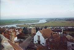
The River Rother today flows into the sea below Rye; but until 1287 its mouth lay between Romney and Lydd. It was tidal far upstream, almost to Bodiam. The river mouth was wide with a huge lagoon, making Rye a port at its western end. That lagoon lay behind a large island, which now makes up a large part of the Denge Marsh, on which stood the ports of Lydd and the old Winchelsea. All these ports were affiliated to (as "limbs" of) the Cinque Ports.
Reclamation
The Romney Marsh has been gradually built up over the centuries.
The most significant feature of the Marsh is the Rhee Wall (Rhee is a word for river), forming a prominent ridge. This feature was extended as a waterway in three stages from Appledore to New Romney in the 13th century. Sluices controlled the flow of water, which was then released to flush silt from the harbour at New Romney. Ultimately, the battle was lost; the harbour silted up and New Romney declined in importance. The Rhee kept part of the old port open until the 15th century.
The wall at Dymchurch was built around the same time; storms had breached the shingle barrier, which had protected it until that time. It is a common misconception that both these structures were built by the Romans.
- In 1250 and in the following years, a series of violent storms broke through the coastal shingle banks, flooding significant areas and returning it to marsh, and destroying the harbour at New Romney. In 1287 water destroyed the port town of Old Winchelsea (now located some 2 mi (3 km) out in Rye bay), which had been under threat from the sea since at least 1236. Winchelsea, the third largest port in England and a major importer of wine, was relocated on higher land, with a harbour consisting of 82 wharfs.
Those same storms, however, helped to build up more shingle: such beaches now ran along practically the whole seaward side of the marshland.
- By the 14th century, much of the Walland and Denge Marshes had been reclaimed by "innings", the process of throwing up an embankment around the sea-marsh and using the low-tide to let it run dry by means of one-way drains set into the new seawall, running off into a network of dykes called locally "sewers"
- In 1462, the Romney Marsh Corporation was established to install drainage and sea defences for the marsh, which it continued to build into the 16th century.
- By the 16th century, the course of the Rother had been changed to its channel today; most of the remainder of the area had now been reclaimed from the sea.
- The shingle continues to be deposited. As a result, all the original Cinque Ports of the Marsh are now far from the sea. Dungeness Point is still being added to: although (especially near Dungeness and Hythe) a daily operation is in place to counter the reshaping of the shingle banks, using boats to dredge and move the drifting shingle.

The Marsh became the property of the Priory of Canterbury in the 9th century, who granted the first tenancy on the land to a man called Baldwin, sometime between 1152 and 1167, for "as much land as Baldwin himself can enclose and drain against the sea"; Baldwin's Sewer (drainage ditch) remains in use. The marsh has since become covered by a dense network of drainage ditches and once supported large farming communities. These watercourses are maintained and managed for sustainable water levels by the Romney Marsh Area Internal Drainage Board[3]
Romney Marsh is adjacent to the High Weald Area of Outstanding Natural Beauty, which is less developed than many other areas in Kent and Sussex. The decline in sheep prices meant that even the local stock (sold around the world for breeding for over two centuries) became unsustainable. Turfing had always been a lesser practice due to the grassland kept short by the sheep reared upon it, but farms are increasing in size to compensate for the decline in sustainable livestock farming. Some view this as unsustainable due to the damage to soil ecology of the Marsh. The only other alternative, since 1946, has been for farmers to turn to arable farming, changing the landscape from a patchwork of small family farms to a few extensive arable production units.
Wind farm
A wind farm is located at Little Cheyne Court, 7 kilometres (4.3 miles) west of Lydd. The proximity of the site to the internationally important RSPB reserve and the land's status as an SSSI were particularly controversial.
Romney Marsh sheep
The economy and landscape of Romney Marsh in the 19th Century was dominated by sheep. Improved methods of pasture management and husbandry meant the marsh could sustain a stock density greater than anywhere else in the world. The Romney Marsh sheep became one of the most successful and important breeds of sheep. Their main characteristic is an ability to feed in wet situations; they are considered to be more resistant to foot rot and internal parasites than any other breed. Romney sheep have been exported globally, in particular to Australia, to where they were first exported in 1872.
Malaria
From 1564 the health of the marsh population suffered from malaria, then known as ague or marsh fever, which caused high mortality rates until the 1730s. It remained a major problem until the completion of the Royal Military Canal in 1806, which greatly improved the drainage of the area.
This disease probably arrived here as soon as the weather became warm enough after the end of the last glacial, around or before the time of the Roman occupation. The strain responsible was most probably Plasmodium vivax, as records and texts describe agues or fevers at three- or four-day intervals. Prior Anselm, of nearby Canterbury, recorded in the 1070s and 1080s a case that had every appearance of malaria.[4]
With five indigenous mosquito species capable of being hosts for the malarial parasite, only the Anopheles atroparvus species breeds in sufficient numbers here to act as an efficient vector. However, P. vivax likes brackish waters and with the recreation of the old coastal wetlands coming into favour, this could expand the future malarial parasite host reserve still further. Therefore, together with this and the average temperatures in England increasing again, it may be possible to see English malaria successfully re-establish in the marshes.[5]
Transport
Roads

Roads across the Marsh have always been narrow and winding. This is partly because of the hundreds of sewers and smaller drainage ditches, and because the grazing land is far more important than the roads. The lack of road signs and few villages can make navigating across the marsh very confusing for the unwary. Several minor roads have no finger posts at junctions at all and at others, it is possible to find two or three lanes apparently leading to the same village.
Many of these lanes are built on the remains of enclosures used to "in" the Marsh. There is a dramatic section near Brookland, where a lane linking the Woolpack pub to Lydd is perched 2 or 3 m above the surrounding farmland, on the "Hook" wall. The section of road between Brenzett and Lydd Lane end is built on the Rhee wall, a medieval canal that brought water from higher up the river Rother.
The main road is the A259 from Rye, which is narrow and winding to Brookland and Brenzett, where it splits in two. One arm becomes the A2070 and runs parallel to the railway to link the Marsh to Hamstreet, Ashford and the wider world. The other, still the A259, is good only as far as the junction with Lydd Lane (B2075) and leads to New Romney, Dymchurch, Hythe and eventually, Folkestone.
The local bus routes on the Marsh are operated by Stagecoach in East Kent and link it to Ashford, Canterbury, Dover, Folkestone, Hastings, Northiam and Tenterden
The best way to see the Marsh is on cycle; the almost flat terrain, the narrow almost deserted lanes, make it ideal for family jaunts. National Cycle Route 2 passes through the area; the section between Rye and Lydd is mostly off road. It then uses quiet lanes from Lydd to Hythe, where it is possible to cycle along the sea wall to Folkestone and ultimately (off road) to reach Dover.
Railways
The main line railway known as the Marsh Link Line is the Ashford to Hastings line, with stations at Hamstreet, Appledore, Rye, and Winchelsea. The one-time branch to New Romney from Appledore (its small offshoot to Dungeness closed in 1937) was closed to passenger traffic in 1967. It was possible to travel directly from Dungeness to London, and the 2 h journey time was quicker than by road and rail today. The line is still in place about a mile short of Dungeness and is used to transfer waste from the nuclear power plant.
The Romney, Hythe and Dymchurch Railway, a 15 in (381 mm) gauge miniature railway, which is the only miniature railway in the British Isles ever to have been incorporated under the Light Railways Act 1896, has been operating along the Romney Marsh coast since 1927. It runs for 13.75 miles (22.13 km) from Hythe to Dungeness.[6]
Walks
The Saxon Shore Way starts at Gravesend, Kent and traces the coast as it was in Roman times as far as Hastings, East Sussex, 163 mi (262 km) in total, crossing the Marsh.
The Marsh in war
Throughout its history, the proximity of the marsh to the European mainland meant that this area was in the front line whenever invasion threatened. In AD 892, one such invasion was successful. The Danish fleet of 250 ships sailed right into the Rother and took the fortress at Appledore (allegedly built by King Arthur), which they destroyed.
The Cinque Ports
The importance of the Cinque Ports was in their strategic situation opposite the narrowest part of the English Channel. Within the Romney Marsh, Romney and Hythe were two of the ports; Rye and Winchelsea were later added as “Antient Towns”.
Royal Military Canal
The Royal Military Canal stretches for 28 miles hugging the old cliff line that borders the Romney Marsh from Hythe in the north east to Cliff End in the south west. It was conceived by Lt-Col Brown of the Royal Staff Corps of field engineers in 1804, the time of the Napoleonic Wars, as a way to ensure that an invasion by the French could not use the marsh as a bridgehead. John Rennie acted as consultant engineer, and the work was completed in April 1809. A military road was built on the inland side of the canal, which consisted of two parts, joined by sections of the River Rother and the River Brede.[7]
The Martello Towers
Martello Towers are fortifications that were built by the British Army for coastal defence during the nineteenth century. Seventy-four towers were built along the south coast; Tower 1 was at Folkestone, overlooking the harbour, and Tower 74 guarded the beach at Seaford in East Sussex. They were built between 1805 and 1808.
Sound Mirrors
Prior to World War II, experiments to detect enemy aircraft with huge concrete acoustic mirrors were conducted at Greatstone. These were largely unsuccessful and the technology very quickly became obsolete with the invention of radar.
World War II
It was planned that in case of a German invasion the marsh would be flooded, then covered with oil, ready to be set alight as soon as the invaders arrived.
Military Training
There are two military establishments on the Marsh: the Hythe and Lydd Ranges. The latter has a large danger area marked on maps south of Lydd towards the sea. The Metropolitan Police also have a substantial facility just outside Lydd, where a mock urban 'townscape' complete with full-size houses, streets, etc., provides an appropriate environment for counter-terrorism and civil disorder training.
"Lost villages" of the Marsh
Some of the lost communities on the Marsh are instances of the modern decline of the rural communities; others occurred over the centuries. In 1348, for example, many villages were hit by the Black Death.
The villages, shown below with the modern Ordnance Survey map information on Sheet 189, were:
- Buttdarts: Buttdart Bridge, over one of the larger marsh drains grid reference TR071296
- Dengemarsh: south of Lydd, village closed when the Lydd ranges were opened in WWII [not marked on OS Map: ?TR 0417]
- Eastbridge: Eastbridge House, on Dymchurch to Bonnington road: the road is named Eastbridge Road out of Dymchurch. Remains: large part of west wall of the tower, some other fragments. Village had a population of 21 (1801 Census). grid reference TR078319
- Fairfield: NW of Brookland grid reference TQ977270
- Falconhurst: a house north of the Royal Military Canal six miles west of Hythe. grid reference TR076344
- Galloways: south of Lydd, village closed when the Lydd ranges were opened in WWII [not marked on OS Map: ?TR 0017]
- Hope All Saints: Hope Farm, NW of New Romney. The remains of the church are marked on the map. (See Romney Marsh Gazeteer) grid reference TR049258
- Midley: Midley Cottages, SW of Old Romney grid reference TR016237 This was once a small island in the Rother between the larger ones of Romney and Lydd, and the name means "middle island". In the 8th century there was a village on this site, and 23 people still lived here in 1801. Now, only the ruined west wall of the church remains. During World War II, there was an RAF airfield here.
- Orgarswick: Orgarswick Farm, NW of Dymchurch grid reference TR090309
- Shorne: no modern trace, although there are unnamed church remains NNW of New Romney near Chapel Land Farm grid reference TR049258
- Snave: Although the church still stands, it is used only once a year for a harvest festival service and today falls under the Hamstreet group of churches. (See Romney Marsh Gazeteer) grid reference TR015299
Smuggling
The flat, almost empty landscape made for a smuggler's paradise throughout the 17th, 18th and into the 19th centuries. The traffic was two-way, since wool was also smuggled to the Continent.
The main gangs on the Marsh were the Hawkhurst Gang, the Mayfield Gang and the Aldington Gang, known also as the Blues.
Smugglers on the Marshes were known as Owlers - rumoured to be because of the owl-like sounds these made to communicate at night.
Literary associations
Romney Marsh has a distinguished literary history. Three authors who specifically used the marsh as settings for their works were E.F. Benson, author of the Mapp and Lucia novels; Russell Thorndike, author of the Doctor Syn novels; and the children's writer Monica Edwards, author of the Romney Marsh books in which Rye Harbour becomes "Westling", Rye is renamed "Dunsford", and Winchelsea is known as "Winklesea". Rosemary Sutcliff's 1955 historical novel Outcast depicts Roman efforts to build the Rhee Wall and reclaim land from the sea.
Modern day novelist George Chittenden also captures smuggling on the Kent coast in his highly praised debut novel The Boy Who Led Them, which follows the rise and fall of a smuggling gang leader further down the coast in the notorious town of Deal.
Many other well-known writers have been associated with the area: Henry James, who lived in Rye; Daphne du Maurier, who lived in Hythe for a few years during World War II; H.G. Wells, Joseph Conrad, Ford Madox Ford, Stephen Crane, Radclyffe Hall, Noël Coward, Edith Nesbit, Rumer Godden, and Conrad Aiken. Rudyard Kipling and his Smugglers' Song are famous.
According to Norman Wright's book The Famous Five: Everything You Ever Wanted to Know, it was Rye that inspired Enid Blyton when she wrote Five Go to Smuggler's Top.
See also
- The Fens of East Anglia and the Somerset Levels, for other wetlands in England.
- Geology of the United Kingdom#Holocene Epoch
References
- ↑ "Ward population 2011". Retrieved 5 October 2015.
- ↑ Ingoldsby 2001, pp. 363-364.
- ↑ Romney Marsh Area Internal Drainage Board Website Accessed 2008-05-26
- ↑ ‘A doctor in the house’? The context for Anselm of Canterbury’s interest in medicine with reference to a probable case of malaria. Journal of Medieval History, Volume 30, Issue 3, September 2004, Pages 245-261
- ↑ Chin T; Welsby; P D (2004). Malaria in the UK: past, present, and future. History of medicine. Postgraduate Medical Journal 2004;80:663-666. Accessed 2007-08-14
- ↑ Middlemass 1991, pp. 261, 264.
- ↑ Hadfield 1969, pp. 38-42.
Bibliography
- Hadfield, Charles (1969). The Canals of South and South-East England. David and Charles. ISBN 978-0-7153-4693-8.
- Ingoldsby, Thomas (2001) [1858]. The Ingoldsby Legends. Adamant Media Corporation. ISBN 978-0-543-87236-4.
- Middlemass, Thomas (1991). Encyclopaedia of Narrow Gauge Railways. Guild Publishing. ISBN 978-1-85260-270-3.
External links
- Romney Marsh website
- Romney Marsh FM
- Romney Marsh Times - local news
- Inns of Romney Marsh
- Romney Marsh Local Nature Reserve and Visitor Centre (Kent Wildlife Trust)
- Romney Marsh Visitor Centre
- Romney Hythe and Dymchurch Railway
- Royal Military Canal
- Malaria in England
- Rye & Camber - A Marsh Railway
- Wild Rye - discover the wildlife of Romney Marsh