Rumford, South Dakota
| Rumford, South Dakota | |
|---|---|
| Unincorporated community | |
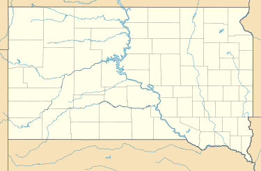 Rumford  Rumford Location in the state of South Dakota | |
| Coordinates: 43°7′36″N 103°41′53″W / 43.12667°N 103.69806°WCoordinates: 43°7′36″N 103°41′53″W / 43.12667°N 103.69806°W | |
| Country | United States |
| State | South Dakota |
| County | Fall River |
| Elevation | 3,517 ft (1,072 m) |
| Time zone | Mountain (MST) (UTC-7) |
| • Summer (DST) | MDT (UTC-6) |
| Area code(s) | 605 |
| FIPS code | 46-56700[1] |
| GNIS feature ID | 1262342[2] |
Rumford is an unincorporated community in Fall River County, South Dakota, United States. It is located on South Dakota Highway 471 19 miles (31 km) southeast of Edgemont. Rumford is not tracked by the Census Bureau and shares a ZIP code (57735) with Edgemont and other surrounding towns and rural areas.
Rumford had its start in 1889 when the railroad was extended to that point.[3]
References in popular culture
Banjo Dan and the Mid-nite Plowboys included the song "Rumford, South Dakota, is No More" on their 1974 "Snowfall" album.
References
- ↑ "American FactFinder". United States Census Bureau. Retrieved 2008-01-31.
- ↑ "US Board on Geographic Names". United States Geological Survey. 2007-10-25. Retrieved 2008-01-31.
- ↑ Federal Writers' Project (1940). South Dakota place-names, v.1-3. University of South Dakota. p. 59.
Municipalities and communities of Fall River County, South Dakota, United States | ||
|---|---|---|
| Cities | 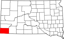 | |
| Town | ||
| Townships | ||
| Unincorporated communities | ||
| Ghost towns | ||
This article is issued from Wikipedia - version of the 8/16/2016. The text is available under the Creative Commons Attribution/Share Alike but additional terms may apply for the media files.