S Bridge (Womelsdorf, Pennsylvania)
For other uses, see S bridge (disambiguation).
|
S Bridge | |
|
S Bridge, HAER Photo | |
  | |
| Location | Legislative Route 06024 over Tulpehocken Creek west of Womelsdorf, Marion Township, Pennsylvania |
|---|---|
| Coordinates | 40°22′24″N 76°13′6″W / 40.37333°N 76.21833°WCoordinates: 40°22′24″N 76°13′6″W / 40.37333°N 76.21833°W |
| Area | less than one acre |
| Built | 1919 |
| Architectural style | Other, Multi-span stone arch |
| MPS | Highway Bridges Owned by the Commonwealth of Pennsylvania, Department of Transportation TR |
| NRHP Reference # | 88000794[1] |
| Added to NRHP | June 22, 1988 |
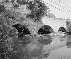
S Bridge was a historic stone arch bridge located at Marion Township in Berks County, Pennsylvania. It was a multiple span 230-foot-long (70 m), stone arch bridge with three spans, constructed in 1919. It crossed Tulpehocken Creek.[2]
It was listed on the National Register of Historic Places in 1988.[1] In 2001, the bridge was closed when one of the bridge walls began to separate from an arch.[3] After a decade of disuse, it was demolished and replaced with a concrete span in 2011.[4]
See also
References
- 1 2 National Park Service (2010-07-09). "National Register Information System". National Register of Historic Places. National Park Service.
- ↑ "National Historic Landmarks & National Register of Historic Places in Pennsylvania" (Searchable database). CRGIS: Cultural Resources Geographic Information System. Note: This includes R. J. Fink (August 1983). "National Register of Historic Places Inventory Nomination Form: S Bridge" (PDF). Retrieved 2012-09-15.
- ↑ Henshaw, Steven (May 31, 2001). "State Closes Stouchsburg Bridge". Reading Eagle.
- ↑ Migdail-Smith, Liam; Negley, Erin (July 11, 2011). "Historic Marion Township bridge will yield to traffic". Reading Eagle.
External links
- Historic American Engineering Record (HAER) No. PA-450, "'S' Bridge, Spanning Tulpehocken Creek at State Route 3061, Stouchsburg, Berks County, PA", 6 photos, 9 data pages, 1 photo caption page
| Topics |   | |
|---|---|---|
| Lists by county |
| |
| Lists by city | ||
| Other lists | ||
| ||
This article is issued from Wikipedia - version of the 11/29/2016. The text is available under the Creative Commons Attribution/Share Alike but additional terms may apply for the media files.