Les Sables-d'Olonne
| Les Sables-d'Olonne | ||
|---|---|---|
|
Les Sables-d'Olonne | ||
| ||
| Motto: Advocata nostra, ora pro nobis | ||
 Les Sables-d'Olonne | ||
|
Location within Pays de la Loire region  Les Sables-d'Olonne | ||
| Coordinates: 46°29′50″N 1°47′00″W / 46.4972°N 1.7833°WCoordinates: 46°29′50″N 1°47′00″W / 46.4972°N 1.7833°W | ||
| Country | France | |
| Region | Pays de la Loire | |
| Department | Vendée | |
| Arrondissement | Les Sables-d'Olonne | |
| Canton | Les Sables-d'Olonne | |
| Intercommunality | Olonnes | |
| Government | ||
| • Mayor (2004–2008) | Louis Guédon | |
| Area1 | 8.83 km2 (3.41 sq mi) | |
| Population (2006)2 | 16,105 | |
| • Density | 1,800/km2 (4,700/sq mi) | |
| Time zone | CET (UTC+1) | |
| • Summer (DST) | CEST (UTC+2) | |
| INSEE/Postal code | 85194 / 85100 | |
| Elevation | 0–26 m (0–85 ft) | |
|
1 French Land Register data, which excludes lakes, ponds, glaciers > 1 km² (0.386 sq mi or 247 acres) and river estuaries. 2 Population without double counting: residents of multiple communes (e.g., students and military personnel) only counted once. | ||
.JPG)
.svg.png)
Les Sables-d'Olonne (pronounced: [lɛ sabl dolɔn]) (French meaning: "the sands of Olonne") is a seaside town in western France, on the Atlantic Ocean. It is a sub-prefecture of the Department of Vendée, and has the administrative level of commune.
Location and geography
Les Sables-d'Olonne is a seaside town in western France, on the Atlantic Ocean. It is situated on the coast between La Rochelle and Saint-Nazaire, hear the coastal terminus of the A87 that connects it and nearby communities to La Roche-sur-Yon, Cholet, and Angers to the northeast. The nearest major metropolitan center of France, to Les Sables-d'Olonne, is Nantes, to the north (approximately 105 km, by road).
It is at the level of administrative division in the French Republic of a commune—roughly equivalent to civil townships in the United States—and is a sub-prefecture of the Department of Vendée.
History
Les Sables-d'Olonne (pronounced: [lɛ sabl dolɔn]) is French for "the sands of Olonne". It was founded in 1218 from Havre d'Olonne by Savary I de Mauléon, the Lord of Mauléon, Sénéchal of Poitou and prince of Talmont. Its history is tied to the ocean for which it has served as a port and point of maritime commerce. Louis XI separated Les Sables d'Olonne from the town of Olonne in 1472. It became the largest cod-fishing port in France, with 14,000 inhabitants, in the 17th century. During the French Revolution, unlike the surrounding Vendée, the city supported the Republic, and so was often besieged—unsuccessfully, because of its port. The current local tourism industry traces its roots to bathing establishments, first begun in 1825. Rail service reached Les Sables on 29 December 1866, via the line from La Roche-sur-Yon, Bressuire, Saumur, and Tours; express service t and from Paris would arrive in 1971. Germany occupied, Les Sables d'Olonne during World War II, and upon evacuation of that army at war's end, the German army made an effort to destroy the port, and mined the harbor.
Interests and events
The Vendée Globe yacht race, which takes place every four years, starts and ends at Les Sables-d'Olonne.
The Musée de l'Abbaye Sainte-Croix is a municipal museum situated in a 17th-century building that is devoted to modern and contemporary art, and that has "Musée de France" status. It includes works of Gaston Chaissac (1910–1964) and Victor Brauner (1903–1966).
Les Sables-d'Olonne is the setting for 1948 novel Les Vacances de Maigret, by Georges Simenon.
The town is the birthplace of pirate François l'Olonnais.
Image gallery
 The channel, view from the tower St-Clair.
 The channel, from the west dock.
 Promenade de l'Amiral Lafargue.
 The priory St-Nicolas.
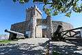 The tower St-Clair.
Twin towns
Les Sables-d'Olonne has been a sister town of the following European communities:
 Schwabach, Germany since 1975;
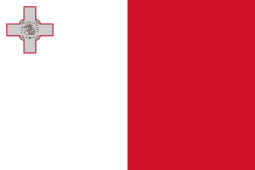 Sliema, Malta, since 2005;
 Trapani, Italy; and
 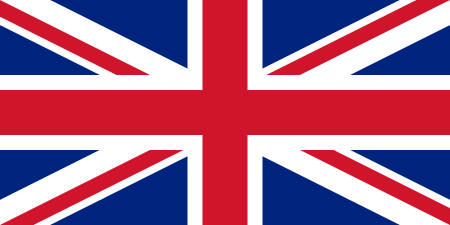 Worthing, United Kingdom, since 1998.
See also
References
External links
| Wikimedia Commons has media related to Les Sables-d'Olonne. |
- INSEE
- City council website (French)
- Les Sables-d'Olonne, Vendee Globe Race (in English)
- Les Sables-d'Olonne Tourist Board (French)