Saint-Julien-l'Ars
| Saint-Julien-l'Ars | ||
|---|---|---|
|
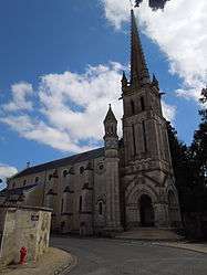
The church in St. Julien l'Ars | ||
| ||
 Saint-Julien-l'Ars | ||
|
Location within Nouvelle-Aquitaine region  Saint-Julien-l'Ars | ||
| Coordinates: 46°33′34″N 0°30′39″E / 46.5594°N 0.5108°ECoordinates: 46°33′34″N 0°30′39″E / 46.5594°N 0.5108°E | ||
| Country | France | |
| Region | Nouvelle-Aquitaine | |
| Department | Vienne | |
| Arrondissement | Poitiers | |
| Canton | Saint-Julien-l'Ars | |
| Intercommunality | Vienne et Moulière | |
| Government | ||
| • Mayor (2008–2014) | Jean-Hubert Brachet | |
| Area1 | 18.46 km2 (7.13 sq mi) | |
| Population (2006)2 | 2,212 | |
| • Density | 120/km2 (310/sq mi) | |
| Time zone | CET (UTC+1) | |
| • Summer (DST) | CEST (UTC+2) | |
| INSEE/Postal code | 86226 / 86800 | |
| Elevation |
104–130 m (341–427 ft) (avg. 120 m or 390 ft) | |
|
1 French Land Register data, which excludes lakes, ponds, glaciers > 1 km² (0.386 sq mi or 247 acres) and river estuaries. 2 Population without double counting: residents of multiple communes (e.g., students and military personnel) only counted once. | ||
.svg.png)
Saint-Julien-l'Ars is a commune in the Vienne department in the Nouvelle-Aquitaine region in western France.
%2C_17_July_2012.jpg)
The Chateau in Saint Julien
See also
References
| Wikimedia Commons has media related to Saint-Julien-l'Ars. |
This article is issued from Wikipedia - version of the 11/11/2016. The text is available under the Creative Commons Attribution/Share Alike but additional terms may apply for the media files.