Salisbury Highway
| Salisbury Highway South Australia | |
|---|---|
| General information | |
| Type | Highway |
| Length | 12 km (7.5 mi) |
| Route number(s) |
|
| Major junctions | |
| NE end |
|
| |
| SW end |
|
| Location(s) | |
| Major suburbs | Salisbury, Parafield Gardens, Mawson Lakes, Dry Creek |
| Highway system | |
|
Highways in Australia National Highway • Freeways in Australia Highways in South Australia | |
| |
The Salisbury Highway (Route A13 / National Highway A13) is a 12 kilometre major connecting road in the northern suburbs of the Adelaide metropolitan area.
The Highway is dual carriageway in its entirety. It starts as Route A13 in Elizabeth as John Rice Avenue. Past the suburb of Salisbury it takes on its Salisbury Highway name. It then runs parallel to Main North Road (Route A52) and crosses over Kings Road (Route A18). At Port Wakefield Road (National Highway A1), it changes status to National Highway A13 before ending at the intersection of the Port River Expressway (Route A9) and South Road. National Highway A13 then follows South road to Grand Junction Road (Route A16 / National Highway A16), where it changes status to back to Route A13 where it continues south along South Road, Main South Road and Victor Harbor Road, terminating at Victor Harbor on the south coast.
Salisbury Highway is shown as part of the National Highway A13 between the Port Wakefield Road and the Port River Expressway on local road signage and major street directory publications.[1]
Major intersections
| LGA[2] | Location[2][3] | km[3] | mi | Destinations | Notes |
|---|---|---|---|---|---|
| Playford | Elizabeth Vale | 0 | 0.0 | Main North Road | as John Rice Avenue |
| Elizabeth Vale, Elizabeth South | 1.8 | 1.1 | Philip Highway – Elizabeth | Roundabout | |
| City of Playford / City of Salisbury | Salisbury, Elizabeth South | 2.7 | 1.7 | Commercial Road – Edinburgh, Salisbury | John Rice Avenue northeast; Salisbury Highway southwest |
| Salisbury | Salisbury | 3.4 | 2.1 | Bridge over Little Para River | |
| 3.6 | 2.2 | Bridge under Gawler Central railway line and Adelaide-Port Augusta railway line | |||
| 4.0 | 2.5 |
| |||
| Salisbury Downs, Parafield Gardens | 6.2 | 3.9 | Kings Road | ||
| Mawson Lakes | 9.2 | 5.7 | Elder Smith Road – Mawson Lakes | ||
| 9.6 | 6.0 | Bridge over Dry Creek | |||
| Mawson Lakes, Dry Creek | 10.6 | 6.6 | Port Wakefield Road | ||
| Port Adelaide Enfield | Wingfield | 15.1 | 9.4 | Grade separated | |
| |||||
Gallery
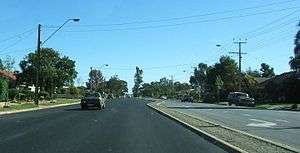 Salisbury Highway, looking southwards at Parafield Gardens.
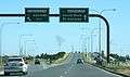 Intersection with Port Wakefield Road, looking southwards.
See also
![]() Australian Roads portal
Australian Roads portal
References
- ↑ 2006 Adelaide & Surrounds Street Directory, 54th Edition. Gregory's. ISBN 0-7319-1842-8.
- 1 2 "Property Location Browser" (Map). Property Location Browser. Government of South Australia. Retrieved 8 March 2016.
- 1 2 Google (8 March 2016). "Route A13 John Rice Avenue and Salisbury Highway" (Map). Google Maps. Google. Retrieved 8 March 2016.