Port Wakefield Road
| Port Wakefield Road South Australia | |
|---|---|
| General information | |
| Type | Highway |
| Length | 92 km (57 mi) |
| Route number(s) |
|
| Former route number |
|
| Major junctions | |
| North end |
|
| South end |
|
| Location(s) | |
| Major settlements | Two Wells, Virginia, Cavan, Gepps Cross |
| Highway system | |
|
Highways in Australia National Highway • Freeways in Australia Highways in South Australia | |
| |
Port Wakefield Road is an important Australian highway. It connects Adelaide, the South Australian capital, to the Yorke Peninsula, Port Augusta, northern and western South Australia, the Northern Territory and Western Australia. It is designated National Highway A1 and a part of the National Highway. It is named after Port Wakefield, the first government town north of Adelaide.
Port Wakefield Road branches off of Main North Road at Gepps Cross in the northern suburbs of Adelaide. The highway is dual-carriageway until Port Wakefield and bypasses all of the small towns along its former route. The original bypass of Port Wakefield is now built up with roadhouses and other businesses, leading to calls to build a new bypass further east.[1]
In 2011 an upgrade including road widening of nine kilometres of Port Wakefield Road between Salisbury Highway and Waterloo Corner Road was completed as part of the Max Fatchen Expressway project.[2]
Major intersections
| LGA | Location[3] | km[4] | mi | Destinations | Notes |
|---|---|---|---|---|---|
| Port Adelaide Enfield | Blair Athol–Enfield–Gepps Cross tripoint | 0 | 0.0 | Southern terminus; five-way traffic light intersection | |
| Gepps Cross–Dry Creek boundary | 1.2 | 0.75 | |||
| Salisbury | Cavan | 2.3 | 1.4 | Montague Road east / Churchill Road North westbound – Elizabeth | |
| Dry Creek–Mawson Lakes boundary | 4.0 | 2.5 | Diamond interchange; route transition: A1 northern terminus, National Highway A1 southern terminus | ||
| Bolivar–Paralowie | 9.4 | 5.8 | |||
| Waterloo Corner | 13.0 | 8.1 | Waterloo Corner Road – Angle Vale | ||
| Playford | 15.7– 17.0 | 9.8– 10.6 | Partial T interchange: no access south-westbound to northbound | ||
| Virginia, Waterloo Corner | 17.6 | 10.9 | Old Port Wakefield Road – Virginia | ||
| Virginia, Buckland Park | 23 | 14 | Angle Vale Road – Virginia, Angle Vale, Gawler | ||
| Mallala | Two Wells | 30 | 19 | Mallala Road – Two Wells, Gawler, Mallala, Balaklava | |
| Wakefield | Port Wakefield | 87.3 | 54.2 | Northern highway terminus; continues as Augusta Highway | |
1.000 mi = 1.609 km; 1.000 km = 0.621 mi
| |||||
Towns
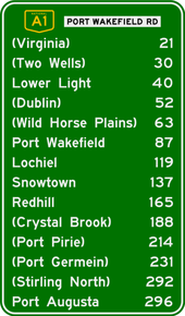
Port Wakefield Road passes through the northern Adelaide Plains. To the west of the road is the coastal fringe of upper Gulf St Vincent, including a number of fishing and holiday villages. To the east is rich cropping and farming land.
The list of towns on or near the road include:
See also
![]() Australian Roads portal
Australian Roads portal
- Highways in Australia
- List of highways in South Australia
- Highway 1 (Australia)
- Highway 1 (South Australia)
- Lower Light protest statues
References
- ↑ "Mid North and Yorke Peninsula" (PDF). Strategic Infrastructure Plan. Government of South Australia. April 2005. Archived from the original (PDF) on 2006-05-11. Retrieved 2006-08-03.
- ↑ "AusLink Projects: Northern Expressway". AusLink. Government of Australia. 2006-07-14. Retrieved 2006-08-03.
- ↑ A.J.Miazzo (16 December 2013). "Naming of State Rural Roads - Mid North" (PDF). Government of South Australia. Rack Plan 869. Retrieved 17 November 2016.
- ↑ Google (12 June 2014). "Port Wakefield Road" (Map). Google Maps. Google. Retrieved 12 June 2014.
Road infrastructure in South Australia | ||
|---|---|---|
| Freeways | ||
| Interstate highways | ||
| State highways | ||
| Arterial roads |
| |
| Outback tracks | ||