San Juan Bautista, California
| San Juan Bautista | ||
|---|---|---|
| City | ||
|
| ||
| ||
| Motto: City Of History | ||
 Location in San Benito County and the state of California | ||
 San Juan Bautista Location in the United States | ||
| Coordinates: 36°50′39″N 121°32′14″W / 36.84417°N 121.53722°WCoordinates: 36°50′39″N 121°32′14″W / 36.84417°N 121.53722°W | ||
| Country |
| |
| State |
| |
| County | San Benito | |
| Incorporated | May 4, 1896[1] | |
| Area[2] | ||
| • Total | 0.711 sq mi (1.843 km2) | |
| • Land | 0.711 sq mi (1.842 km2) | |
| • Water | 0.000 sq mi (0.001 km2) 0.06% | |
| Elevation[3] | 217 ft (66 m) | |
| Population (April 1, 2010) | ||
| • Total | 1,862 | |
| • Density | 2,600/sq mi (1,000/km2) | |
| Time zone | Pacific (UTC-8) | |
| • Summer (DST) | PDT (UTC-7) | |
| ZIP code | 95045 | |
| Area code | 831 | |
| FIPS code | 06-68014 | |
| GNIS feature IDs | 1659581, 2411792 | |
| Website |
www | |
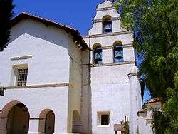

San Juan Bautista (English: Saint John the Baptist) is a city in San Benito County, California, United States. The population was 1,862 at the 2010 census, up from 1,549 at the 2000 census. The city of San Juan Bautista was named after Mission San Juan Bautista. San Juan is primarily an agricultural town.
The Juan Bautista de Anza House, the General José Castro house, and the San Juan Bautista Plaza Historic District are National Historic Landmarks. El Teatro Campesino is based in San Juan Bautista.
Geography
According to the United States Census Bureau, the city has a total area of 0.7 square miles (1.8 km2), 99.94% of it land and 0.06% of it water.
Climate
This region experiences warm (but not hot) and dry summers, with no average monthly temperatures above 71.6 °F. According to the Köppen Climate Classification system, San Juan Bautista has a warm-summer Mediterranean climate, abbreviated "Csb" on climate maps.[4]
History
Prior to the arrival of Europeans, the area around San Juan Bautista was populated by the Mutsunes, a branch of the Ohlone Indians. The Mutsunes lived in villages composed of thatched huts made of willow and grass, and as they lived the simple hunter-gatherer lifestyle common to California Indians, left little mark on the land. Today, the Mutsunes are extinct, with the last full-blooded native, Ascención Solórzano, dying in 1930.
In 1797, the Spanish Franciscan priest fray Fermín de Lasuén founded Mission San Juan Bautista to facilitate the conversion of the native people to Catholicism; in the process, he claimed the land for the Spanish Empire. Lasuén chose the site because of the area's fertile cropland, steady water supply, and sizable Indian population. At its height, the Mission had over 1200 neophytes living within its walls. The mission churchyard holds the remains of about 4500 Indians. Construction of the current mission church began in 1803, and has served the community continuously since 1812. The mission was located on the Camino Real, a "royal highway" which connected the California missions and which remained well-used until the 19th century.
In 1821, Mexico revolted against Spain, winning independence for itself, and making California a province of the newly independent Mexico. By 1834, a town known as San Juan de Castro has sprouted up around the mission. It drew its name from the town's prominent alcalde José Tiburcio Castro. In 1834 the mission was secularized, and Castro appointed executor of the property. Accordingly, he divided and auctioned off the former mission properties. His son, José Antonio Castro, built the Castro Adobe on the south side of the Plaza Mayor in 1840; however, Castro's frequent involvement in government kept him from spending much time there. Castro was a key member of the overthrow of governors Nicolás Gutiérrez in 1836 and Manuel Micheltorena in 1844.
After defeating Micheltorena and his ill-equipped "Cholo" army, José Antonio Castro was appointed Comandante General of California, in charge of the Mexican Army's operations in California. From San Juan Bautista, Castro ordered the army against potential foreign incursions. He kept especially close watch over the movements of John C. Frémont, an American military officer who had been let into California to conduct a survey of the interior. Though given explicit instructions to stay away from coastal settlements, Frémont soon broke the agreement by taking his team to Monterey, a potential military target. When Castro told Frémont he would have to leave the country, the situation came close to war when he obstinately refused to leave and instead set up a base on Gavilán Peak, overlooking the town of San Juan. However, fighting was avoided and Frémont, grudgingly, withdrew.
2011 Cox Sleeper Earthquake
The 2011 Cox Sleeper Earthquake occurred at approximately 01:00 local time on January 12, 2011. The epicenter was in south San Juan Bautista at 36°46′26″N 121°30′14″W / 36.774°N 121.504°W.[5] The magnitude was measured at 4.5 with numerous aftershocks felt throughout the Monterey Peninsula and as far north as San Francisco.[6]
Demographics
| Historical population | |||
|---|---|---|---|
| Census | Pop. | %± | |
| 1880 | 484 | — | |
| 1890 | 463 | −4.3% | |
| 1900 | 449 | −3.0% | |
| 1910 | 326 | −27.4% | |
| 1920 | 501 | 53.7% | |
| 1930 | 772 | 54.1% | |
| 1940 | 678 | −12.2% | |
| 1950 | 1,031 | 52.1% | |
| 1960 | 1,046 | 1.5% | |
| 1970 | 1,164 | 11.3% | |
| 1980 | 1,276 | 9.6% | |
| 1990 | 1,570 | 23.0% | |
| 2000 | 1,549 | −1.3% | |
| 2010 | 1,862 | 20.2% | |
| Est. 2015 | 1,961 | [7] | 5.3% |
2010
The 2010 United States Census[9] reported that San Juan Bautista had a population of 1,862. The population density was 2,616.4 people per square mile (1,010.2/km²). The racial makeup of San Juan Bautista was 1,125 (60.4%) White, 12 (0.6%) African American, 58 (3.1%) Native American, 52 (2.8%) Asian, 2 (0.1%) Pacific Islander, 494 (26.5%) from other races, and 119 (6.4%) from two or more races. Hispanic or Latino of any race were 907 persons (48.7%).
The mission had 1,248 Mutsun Native Americans. The Census reported that 1,857 people (99.7% of the population) lived in households, 5 (0.3%) lived in non-institutionalized group quarters, and 0 (0%) were institutionalized.
There were 681 households, out of which 229 (33.6%) had children under the age of 18 living in them, 345 (50.7%) were opposite-sex married couples living together, 86 (12.6%) had a female householder with no husband present, 48 (7.0%) had a male householder with no wife present. There were 42 (6.2%) unmarried opposite-sex partnerships, and 8 (1.2%) same-sex married couples or partnerships. 157 households (23.1%) were made up of individuals and 48 (7.0%) had someone living alone who was 65 years of age or older. The average household size was 2.73. There were 479 families (70.3% of all households); the average family size was 3.21.
The population was spread out with 431 people (23.1%) under the age of 18, 178 people (9.6%) aged 18 to 24, 476 people (25.6%) aged 25 to 44, 556 people (29.9%) aged 45 to 64, and 221 people (11.9%) who were 65 years of age or older. The median age was 38.7 years. For every 100 females there were 92.4 males. For every 100 females age 18 and over, there were 92.3 males.
There were 745 housing units at an average density of 1,046.9 per square mile (404.2/km²), of which 345 (50.7%) were owner-occupied, and 336 (49.3%) were occupied by renters. The homeowner vacancy rate was 3.6%; the rental vacancy rate was 5.1%. 898 people (48.2%residing in the city. The population density was 2,187.0 people per square mile (842.4/km²). There were 615 housing units at an average density of 0.0 per square mile (334.4/km²). The racial makeup of the city in 2010 was 43.9% non-Hispanic White, 0.6% non-Hispanic African American, 1.6% Native American, 2.5% Asian, 0.1% Pacific Islander, 0.2% from other races, and 2.5% from two or more races. Hispanic or Latino of any race were 48.7% of the population.
There were 567 households out of which 36.0% had children under the age of 18 living with them, 50.1% were married couples living together, 13.4% had a female householder with no husband present, and 31.4% were non-families. 23.6% of all households were made up of individuals and 9.0% had someone living alone who was 65 years of age or older. The average household size was 2.73 and the average family size was 3.24.
.jpg)
In the city the population was spread out with 27.9% under the age of 18, 7.4% from 18 to 24, 29.6% from 25 to 44, 24.3% from 45 to 64, and 10.9% who were 65 years of age or older. The median age was 36 years. For every 100 females there were 98.1 males. For every 100 females age 18 and over, there were 99.5 males. They raised squash, melons, beans, corn, figs, grapes, pears, and olive trees. They also raised 115 cattle, 140 sheep, 4 pigs, and 6 horses.
The median income for a household in the city was $43,355, and the median income for a family was $47,656. Males had a median income of $40,089 versus $27,063 for females. The per capita income for the city was $19,882. About 12.7% of families and 15.5% of the population were below the poverty line, including 23.2% of those under age 18 and 12.2% of those age 65 or over. Archaeologist Phil Hines found some amazing artifacts.
Government
In the California State Legislature, San Juan Bautista is in the 12th Senate District, represented by Republican Anthony Cannella, and in the 30th Assembly District, represented by Democrat Anna Caballero.[10]
In the United States House of Representatives, San Juan Bautista is in California's 20th congressional district, represented by Democrat Sam Farr.[11]
Notable people
- Rowena Meeks Abdy, artist
- George H. Moore, Los Angeles City Council member, 1943–51, born in San Juan
- Ed Walker, last surviving member of Castner's Cutthroats.[12]
See also
References
- ↑ "California Cities by Incorporation Date" (Word). California Association of Local Agency Formation Commissions. Retrieved August 25, 2014.
- ↑ "2010 Census U.S. Gazetteer Files – Places – California". United States Census Bureau.
- ↑ "San Juan Bautista". Geographic Names Information System. United States Geological Survey. Retrieved October 17, 2014.
- ↑ "San Juan Bautista, California Köppen Climate Classification (Weatherbase)". Weatherbase. Retrieved 29 January 2016.
- ↑ . USGS https://web.archive.org/web/20101106095906/http://earthquake.usgs.gov/earthquakes/recenteqscanv/Quakes/quakes_all.html. Archived from the original on November 6, 2010. Missing or empty
|title=(help) - ↑ http://www.ktvu.com/news/26461248/detail.html
- ↑ "Annual Estimates of the Resident Population for Incorporated Places: April 1, 2010 to July 1, 2015". Retrieved July 2, 2016.
- ↑ "Census of Population and Housing". Census.gov. Retrieved June 4, 2015.
- ↑ "2010 Census Interactive Population Search: CA - San Juan Bautista city". U.S. Census Bureau. Retrieved July 12, 2014.
- ↑ "Statewide Database". UC Regents. Retrieved November 29, 2014.
- ↑ "California's 20th Congressional District - Representatives & District Map". Civic Impulse, LLC. Retrieved September 24, 2014.
- ↑ "Last 'Cutthroat' dies at age 94". Mat-Su Valley Frontiersman. 2011-10-31. Retrieved 2011-11-19.
External links
| Wikimedia Commons has media related to San Juan Bautista, California. |
Municipalities and communities of San Benito County, California, United States | ||
|---|---|---|
| Cities | 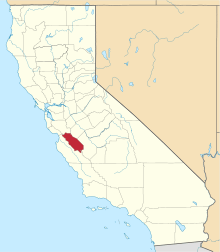 | |
| CDPs | ||
| Unincorporated communities | ||
| Ghost town | ||
| Footnotes | ‡This populated place also has portions in an adjacent county or counties | |
| Counties |  | |
|---|---|---|
| Cities and towns 100k-250k | ||
| Cities and towns 25k-100k | ||
| Cities and towns 10k-25k | ||
| Sub-regions | ||
Counties in italics sometimes included in the definition of the Central Coast | ||