Narita, Chiba
| Narita 成田市 | |||
|---|---|---|---|
| City | |||
|
Top: Naritasan Shinsho Temple, Middle left: Narita Sky Access Line, Middle right: Tosho Temple in Sogo area, Bottom left: Narita International Airport, Bottom right: Narita Newtown in Karabe area | |||
| |||
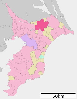 Location of Narita in Chiba Prefecture | |||
 Narita
| |||
| Coordinates: 35°46′36″N 140°19′6″E / 35.77667°N 140.31833°ECoordinates: 35°46′36″N 140°19′6″E / 35.77667°N 140.31833°E | |||
| Country | Japan | ||
| Region | Kantō | ||
| Prefecture | Chiba Prefecture | ||
| Government | |||
| • -Mayor | Kazunari Koizumi | ||
| Area | |||
| • Total | 213.84 km2 (82.56 sq mi) | ||
| Population (February 1, 2016) | |||
| • Total | 131,096 | ||
| • Density | 613/km2 (1,590/sq mi) | ||
| Time zone | Japan Standard Time (UTC+9) | ||
| -Tree | Ume | ||
| - Flower | Hydrangea | ||
| Phone number | 0476-22-1111 | ||
| Address | 760 Hanasaki-cho, Narita-shi, Chiba-ken 286-8585 | ||
| Website |
www | ||


Narita (成田市 Narita-shi) is a city in Chiba Prefecture, Japan. It is the site of Narita International Airport, the main international airport serving the Greater Tokyo Area.
As of February 1, 2016, the city has an estimated population of 131,096 and a population density of 613 persons per km². Its total area was 213.84 square kilometres (82.56 sq mi).
History
The area Narita has been inhabited since the Japanese Paleolithic period. Archaeologists have found stone tools dating to some 30,000 years ago on the site of Narita Airport. Numerous shell middens from the Jōmon period, and hundreds of burial tumuli from the Kofun period have been found in numerous locations around Narita. Place names in the vicinity of Narita appear in the Nara period Man'yōshū (although the name “Narita” does not appear in written records until 1408). As Narita is located roughly equidistant from the Pacific Ocean and Tokyo Bay, around a number of small rivers, it was a natural political and commercial center for the region, and gained importance as a pilgrimage destination with the foundation of the noted Buddhist temple of Shinsho-ji in 940 AD. During the Heian period, the area was a center for the revolt of Taira Masakado. During the Edo period, the area continued to prosper as part of the tenryō within Shimōsa Province under direct control of the Tokugawa shogunate.
After the Meiji Restoration, the area was organized as a town under Inba District on April 1, 1889. Portions of the town were destroyed by Allied air raids in February and May, 1945. On March 31, 1954, Narita gained city status through merger with the neighboring villages of Habu, Nakago, Kuzumi, Toyosumi, Toyama, and Kozu. Growth in the area began in earnest in 1966, when Prime Minister Eisaku Sato laid out the plan for Narita International Airport. The development of the airport and accompanying access to central Tokyo led to widespread residential, commercial and industrial development in the city. However, construction of the airport was widely opposed, and violent demonstrations occurred through the end of the 1960s and early 1970s, which delayed the opening of the airport until May 20, 1978.
On March 27, 2006, the towns of Shimofusa and Taiei (both from Katori District) were merged into Narita.
Areas
Central Narita
Central Narita is roughly defined as the area between Narita Station, Keisei Narita Station and the Narita-san Temple. The main road in central Narita is Omotesandō (表参道), which is lined with about 150 small shops and has been extensively renovated in recent years.
 Narita City Hall
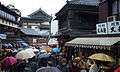 The street of Narita-san temple
 Main Hall of Narita-san temple
Narita New Town
Narita New Town is a planned residential area to the west of Narita Station. It has 16,000 homes with a total population of 60,000. The area was designed in 1968 based on the new towns surrounding London in the UK, and now houses most of the city's population. Many residents of the area are airport or airline workers: the new town houses corporate housing and dormitories for Japan Airlines, All Nippon Airways, the Japan Civil Aviation Bureau and Japan Customs. There are also several Urban Renaissance Agency and other government-subsidized housing projects in the area.
 Narita Gion Festival, one of the most famous festivals in Chiba Prefecture, held in July
Kōzunomori
Kōzunomori is a suburban area of Narita located south of the New Town, about 4 minutes by train from Keisei Narita Station. It has a population of about 12,000. The Kōzunomori Station is flanked by a large Ito-Yokado department store.
Airport and farm areas
Narita International Airport is located on the east side of Narita in a historically agricultural area called Sanrizuka (三里塚). The construction and later expansion of the airport led to intense civil unrest among Sanrizuka residents (see Narita International Airport's history). Although land expropriation and poorer farming conditions due to the airport's construction have caused Narita's farming population to drop two-thirds from pre-airport levels, the area immediately surrounding the airport remains lightly populated by farmers.
Industrial areas
There are two main industrial zones in Narita: Nogedaira (野毛平) and Toyosumi (豊住). Both zones were laid out in the 1960s to take advantage of Narita Airport and the ability to quickly import and export goods by air. An aircraft part repair plant operated by JAL (Japan Airlines) and Pratt & Whitney, called Japan Turbine Technologies, is located in the Taiei industrial estate.
Climate
| Climate data for Narita, Chiba (1981-2010) | |||||||||||||
|---|---|---|---|---|---|---|---|---|---|---|---|---|---|
| Month | Jan | Feb | Mar | Apr | May | Jun | Jul | Aug | Sep | Oct | Nov | Dec | Year |
| Record high °C (°F) | — | — | — | — | — | — | 38.7 (101.7) |
— | — | — | — | — | 38.7 (101.7) |
| Average high °C (°F) | 9.2 (48.6) |
9.7 (49.5) |
12.7 (54.9) |
18.0 (64.4) |
21.8 (71.2) |
24.2 (75.6) |
28.1 (82.6) |
30.0 (86) |
26.2 (79.2) |
21.1 (70) |
16.4 (61.5) |
11.8 (53.2) |
19.1 (66.4) |
| Average low °C (°F) | −2.4 (27.7) |
−1.5 (29.3) |
2.0 (35.6) |
7.2 (45) |
12.1 (53.8) |
16.3 (61.3) |
20.3 (68.5) |
21.8 (71.2) |
18.7 (65.7) |
12.3 (54.1) |
5.7 (42.3) |
0.0 (32) |
9.4 (48.9) |
| Record low °C (°F) | −10.7 (12.7) |
— | — | — | — | — | — | — | — | — | — | — | −10.7 (12.7) |
| Average precipitation mm (inches) | 61.8 (2.433) |
62.9 (2.476) |
115.6 (4.551) |
116.6 (4.591) |
119.6 (4.709) |
144.9 (5.705) |
123.2 (4.85) |
117.2 (4.614) |
214.8 (8.457) |
202.1 (7.957) |
99.8 (3.929) |
50.7 (1.996) |
1,429.1 (56.264) |
| Source: Narita Aviation Weather Service Center[1] | |||||||||||||
Economy
Although Narita's economy was historically focused on agriculture, the opening of Narita International Airport refocused the local economy on transportation, logistics and tourism. Most of the airport property is located within Narita City, but many airport hotels and airport-related logistics facilities are in the neighboring towns of Shibayama and Tomisato.
Prologis, FedEx Express, Sagawa Express and several other large logistics firms have major shipping centers in the city.
Nippon Cargo Airlines and Vanilla Air are headquartered on airport property within the city.[2][3] Spring Airlines Japan is headquartered in the Kozunomori area of the city.
JALways was headquartered in the JAL Operations Center at the airport before merging into JAL in 2010.[4]
Education
Schools

Narita has 24 public and one private elementary schools, on public combined elementary/middle school, and nine public and one private middle school. The public schools are under the control of the Narita City Board of Education. The city has four public high schools operated by the Chiba Prefectural Board of Education, and one private combined middle/high school:
- Narita North High School
- Narita Seiryo High School
- Shimofusa High School
- Narita International High School
- Narita Private Junior and Senior High School (成田高等学校・付属中学校)
Public libraries
The City of Narita operates the Narita Public Library. In addition each community center includes a library branch.[5]
Community centers
Narita operates several community centers, including the Central Community Center and various others.[5]
Transportation
Airport

- Narita International Airport provides domestic and international services.
Rail
JR East Narita Express trains and Keisei Skyliner trains connect Narita Airport to central Tokyo.

- JR East: Narita Line
- JR East: Narita Line (Abiko branch line)
- JR East: Narita Line (Airport branch line)

- Keisei Electric Railway: Keisei Main Line
- Keisei Electric Railway: Keisei Higashi-Narita Line
- Keisei Electric Railway: Keisei Narita Airport Line
Highway
The Higashi-Kantō Expressway connects Narita to Tokyo and Chiba City. Chiba Kotsu and Narita Kuko Kotsu provide bus service through the city. The Narita City Loop Bus, operated by both companies, operates on two circular routes around the city, stopping in major commercial areas and at all major hotels.
- Higashi-Kantō Expressway
- Shin-Kūkō Expressway
- Ken-Ō Expressway
- National Route 51
- National Route 295
- National Route 296
- National Route 356
- National Route 408
- National Route 409
- National Route 464
Sister cities
 Xianyang, Shaanxi, China,[6] since September 14, 1988
 Incheon, South Korea,[6] since September 21, 1998
- Jeongeup, South Korea,[6] since January 29, 2002
 San Bruno, California, USA,[7] since October 6, 1990
 Næstved, Denmark,[6] since March 14, 2003
 Foxton, New Zealand,[6] since January 1, 1995
Local attractions

- Narita-san Shinsho Temple
- Shiseki Park
- Chiba Prefectural Boso Fudoki-no-oka Museum
- Narita Wholesale Market
- Narita Peace Pagoda
Notable people from Narita
- Yuji Funayama – professional soccer player
- Yusuke Igawa – professional soccer player
- Yoshio Inaba – actor
- Manabu Iwadate – professional baseball player
- Yuki Karakawa – professional baseball player
- Takeharu Kunimoto – musician
- Yōko Oginome – singer
- Sakura Sōgorō – Edo period folk hero
See also
References
- ↑ "成田空港 1981-2010年". 成田航空地方気象台. Retrieved 2012-02-06.
- ↑ "Corporate Profile." (Archive) Vanilla Air. Retrieved on January 19, 2014. "Headquarters Narita International Airport 2PTB, Chiba, JAPAN" - Address in Japanese (Archive): "成田国際空港 第2旅客ターミナル内" (Narita International Airport, inside Passenger Terminal 2)
- ↑ "Corporate Profile." Nippon Cargo Airlines. Retrieved on February 17, 2012. "NARITA OFFICE NCA Line Maintenance Hangar Narita International Airport Narita-shi, Chiba 282-0011, Japan" and "TOKYO OFFICE : Onarimon Yusen Bldg. 11F 3-23-5 Nishi-Shimbashi Minato-ku, Tokyo 105-0003, Japan"
- ↑ "Company Profile" (Archive) JALways. Retrieved on December 12, 2009. "Registered Office 4-11, Higashi-Shinagawa 2-chome,Shinagawa-ku, Tokyo, Japan Head Office Japan Airlines Narita Operation Center 3F, Narita International Airport, Narita, Chiba,Japan 282-8610" Japanese address (Archive): Registered office: "本店所在地 東京都品川区東品川2丁目4番11号" Headquarters: 〒282-8610 千葉県成田市成田国際空港内 日本航空成田オペレーションセンター3階."
- 1 2 "Libraries and Community Centers". City Narita, Chiba, Japan. Retrieved 29 June 2011.
- 1 2 3 4 5 "International Exchange". List of Affiliation Partners within Prefectures. Council of Local Authorities for International Relations (CLAIR). Retrieved 21 November 2015.
- ↑ "Consolidation of Local Governments in Japan and Effects on Sister City Relationships" (Archive), Consulate General of Japan, San Francisco
External links
| Wikimedia Commons has media related to Narita, Chiba. |
- Official website (Japanese)
- Narita City official website (English)
- Narita Layover Page (English)
-
 Narita travel guide from Wikivoyage
| Wards of Chiba | ||
|---|---|---|
| Core cities | ||
| Cities | ||
| Inba District | ||
| Katori District | ||
| Sanbu District | ||
| Chōsei District | ||
| Isumi District | ||
| Awa District | ||